Search
Items tagged with: nasaearth

Grab your headphones! 🎧 NASA's Curious Universe podcast is back.
From wildfires here on Earth to Venus’ scorching surface, tune in for a new season of adventures starting Tuesday, Feb. 21. All you need is your curiosity. nasa.gov/curiousuniverse
#NASAEarth
NASA's Curious Universe
NASA.gov brings you the latest images, videos and news from America's space agency. Get the latest updates on NASA missions, watch NASA TV live, and learn about our quest to reveal the unknown and benefit all humankind.NASA

An astronaut on the @Space_Station took these images of the Quirimbas Islands stretching 322 kilometers (200 miles) along Mozambique’s coastline in 2021.
Blue-green water around the islands highlights the shallow complex of corals, sand and seagrass. go.nasa.gov/3HRPKVp
#NASAEarth
Quirimbas Islands
Skirting the coastline of Mozambique, these 32 small islands are home to a diversity of corals and sea turtles.go.nasa.gov
Are you ready for the #SuperBowl? We are! 🏈
#Landsat took this photo of State Farm Stadium in Glendale, AZ.
And in 2020, NASA's ICESat-2 satellite measured the relative elevation of the stadium, which stands over 200 feet tall! go.nasa.gov/3JZLaak
#NASAEarth
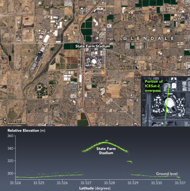
A Super View of Arizona
State Farm Stadium, the site of Super Bowl LVII, stands out from the surrounding desert landscape when viewed from above.go.nasa.gov
#NASAEarth

In August 2022, several college students flew on @nasawallops P-3 aircraft to collect atmospheric data as part of NASA's SaSa program.
“I felt my dreams of becoming a scientist become more tangible,,” said Sophia Ramirez.
Read about their experiences: go.nasa.gov/3XpdyFY
#NASAEarth


Through the @GLOBEProgram, sponsored by @nasa, people around the world can learn about and help with science research like documenting land cover, photographing clouds and taking environmental measurements with kites! 🌳 ☁️ 🪁
Learn more & join today: go.nasa.gov/3jFCknD
#NASAEarth

GLOBE Home Page - GLOBE.gov
The Global Learning and Observation to Benefit the Environment (GLOBE) program is a worldwide hands-on, primary and secondary school-based science and education program.go.nasa.gov

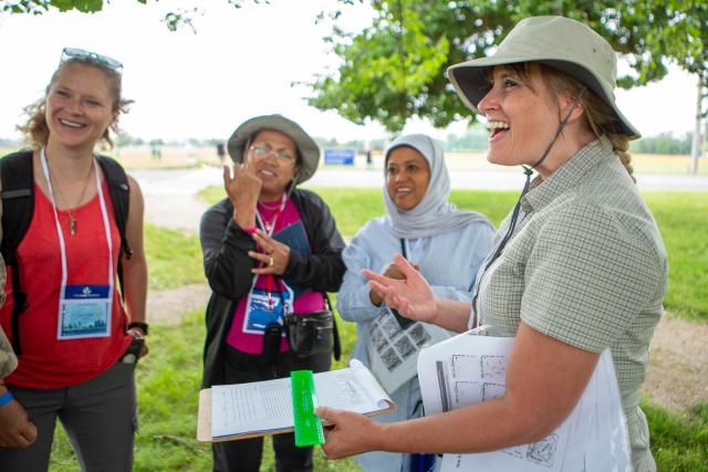
We support women in STEM. 👩🔬👩💻
Today is the @un International Day of Women and Girls in Science. #WomenInScience
To celebrate, we’re highlighting some of the amazing women doing @nasa Earth science!
#NASAEarth
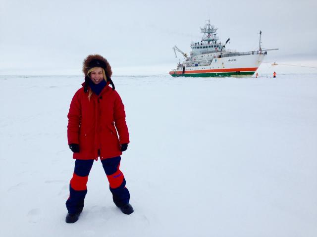
“My younger self would be very proud that I’m here at NASA, doing a job I love.”
Rachel Tilling monitors sea ice cover around the world. Usually this means studying satellite data, but her work also involves traveling to study sea ice up close! 🌊🧊 go.nasa.gov/3xbmt36
#NASAEarth
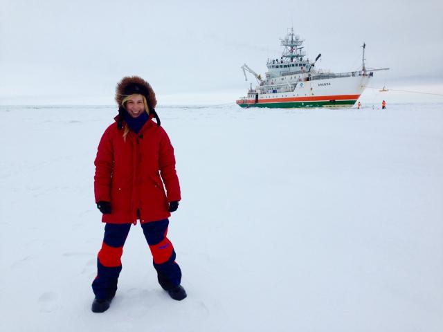
Assistant Research Scientist Rachel Tilling
I hope to have more open conversations about mental health support with my fellow lab members as well as outside of work, so I can help to create a culture that is mental health aware.Thalia Patrinos (NASA)
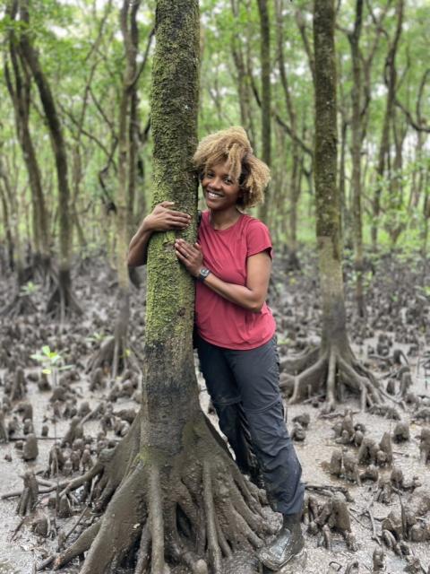
As a research scientist @nasagoddard, Lola Fatoyinbo studies forest ecology and ecosystem structure to understand these important ecosystems and how they are changing. 🌲 #WomenInScience
More from Lola: go.nasa.gov/3xdNTFM
#NASAEarth
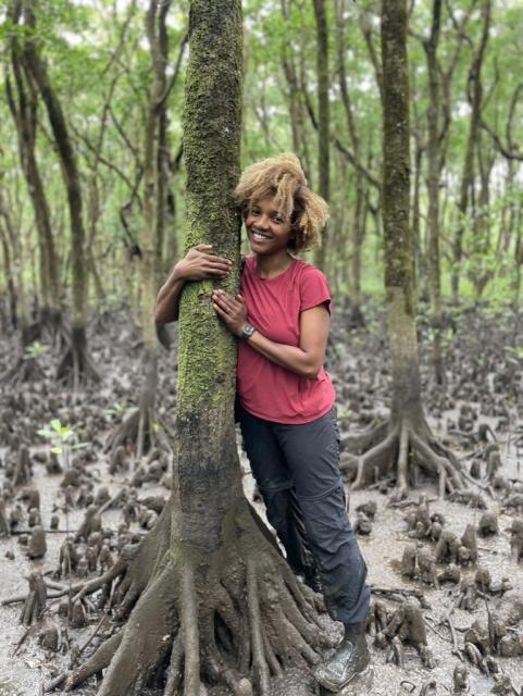
Meet Lola Fatoyinbo, Research Scientist | My NASA Data
Lola Fatoyinbo works at NASA Goddard Space Flight Center. She witnessed deforestation first-hand when she lived in Benin and Ivory Coast, West Africa. She speaks five languages and loves to travel. She discusses her career journey in this interview.My NASA Data
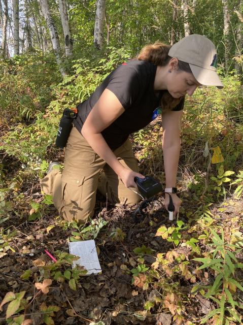
This past summer, Liz Hoy conducted research in Earth’s Arctic and boreal regions with @nasa’s ABoVE. #WomenInScience
The project has been studying these regions – which are seeing the effects of climate change more than most places on Earth – since 2015. go.nasa.gov/3xbHMS5
#NASAEarth

NASA Fieldwork Studies Signs of Climate Change in Arctic, Boreal Regions
The Arctic is being affected by climate change more than most places on Earth. In the summer of 2022, a NASA campaign investigated permafrost thaw, methane emissions from lakes, and the effects of wildfires in Alaska and northwestern Canada.Climate Change: Vital Signs of the Planet
Sarah Bang was terrified of thunderstorms as a child, but she didn’t let that stop her!
Now, she uses sensors on @NASAEarth satellites to detect lightning and hail.
⛈: go.nasa.gov/3xckL1w
#NASAEarth

Remote Sensing Scientist Dr. Sarah Bang
" I was heartbroken by the devastation I saw, and it hit me that this is my calling — the kind of work I must do. If I can contribute in some way to the research on severe storms, I owe it to storm victims to devote my skills and energy to help.Thalia Patrinos (NASA)
Siling Lake – one of the largest water bodies on the Tibetan Plateau – hasn’t plateaued! The lake has been growing in recent decades.
An astronaut on the @Space_Station took this image of Siling Lake on Dec. 4, 2021, when the lake wasn’t frozen over. 💧:go.nasa.gov/3DVx46h
#NASAEarth
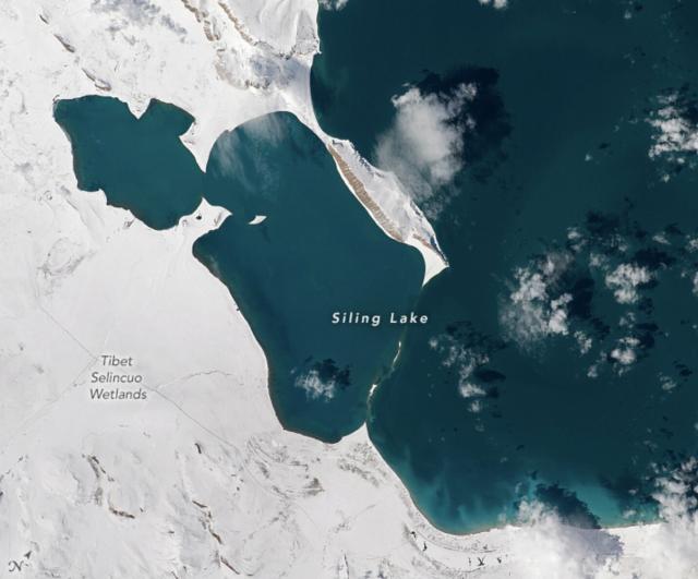
Siling Lake
One of the largest water bodies on the Tibetan Plateau has been growing even larger in recent decades.go.nasa.gov
#NASAEarth
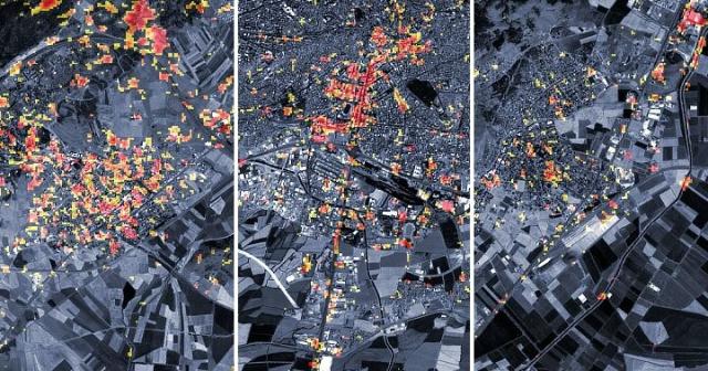
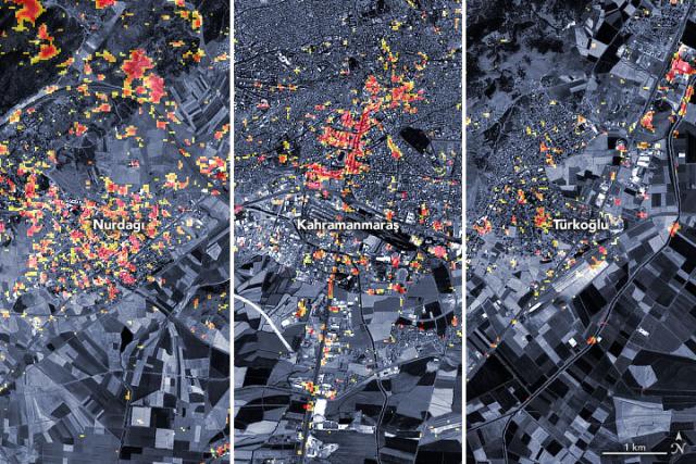
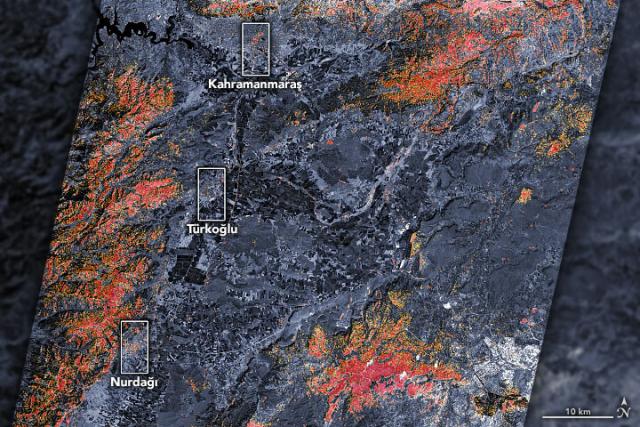
Earthquake Damage in Türkiye
Scientists from NASA and other agencies are using satellites to map damage caused by the devastating earthquake.go.nasa.gov
As new data become available, NASA’s Earth Applied Sciences team is posting near real-time imagery and data products related to the earthquake on its mapping portal.
Get the updates: go.nasa.gov/3jPsHTq
#NASAEarth
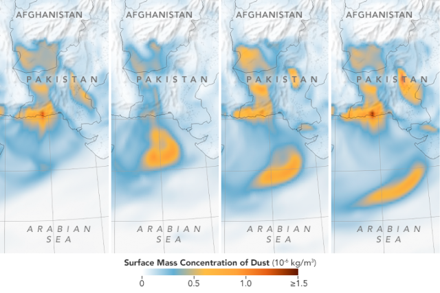
A dried-out Lake Hamun means more dust storms.
The seasonal lake in the Sistan Basin of eastern Iran and southern Afghanistan has been shrinking, reducing vegetation cover and exposing silt and dust. This makes the area a major source of dust storms. go.nasa.gov/3RJ79UZ
#NASAEarth
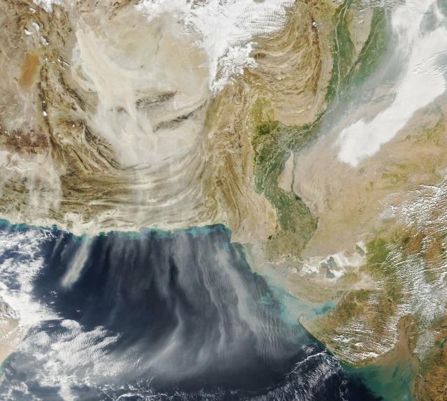
A Dry Lake Hamun Means More Dust Storms
When the seasonal lake and wetlands in the Sistan Basin dry out, dust often fills the sky.go.nasa.gov
This is just one dust storm, but the cumulative effect of Earth's dust storms can have significant effects on the atmosphere.
A UCLA research team found airborne dust has likely increased by 55% on a global scale since pre-industrial times. go.nasa.gov/3RJ79UZ
#NASAEarth
A Dry Lake Hamun Means More Dust Storms
When the seasonal lake and wetlands in the Sistan Basin dry out, dust often fills the sky.go.nasa.gov
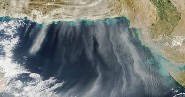
The series of maps below show dust spreading toward the south over Pakistan, India, and the Arabian Sea during six-hour intervals on January 12.
The data came from NASA’s Goddard Earth Observing System (GEOS) modeling system.
#NASAEarth
NASA is committed to #OpenScience – making our data, tools, and resources free and accessible.
At 10:45 ET, Chelle Gentemann, project scientist for @nasa TOPS, is speaking about open science at the @un @unlibrary Open Science Conference.
Stream here: bit.ly/3YvAMeA
#NASAEarth

1st Day: 3rd Open Science Conference: Accelerating the Sustainable Development Goals, Democratizing the Record of Science
The record of science is not yet as open to researchers and the public as it ought to be. In the era of new digital and data infrastructures, scientific and scholarly publishing remains aligned with the Gutenbergian model of the scholarly communicati…UN Web TV
NASA, along with the @WhiteHouse and other federal agencies, has declared 2023 a #YearOfOpenScience to celebrate the benefits and successes created through the open sharing of data, information, and knowledge.
Learn more: bit.ly/3jFWAoW
#NASAEarth

Welcome to A Year of Open Science!
The federal government has declared 2023 the Year of Open ScienceJosh Blumenfeld (Earthdata)
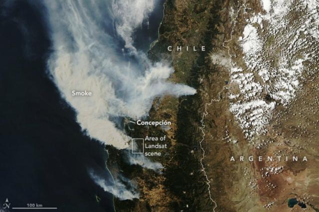
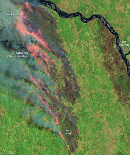
Widespread #fires have been raging through south-central Chile since Feb. 2, 2023.
NASA’s Aqua satellite acquired this image of the fires on Feb. 3 showing smoke billowing from Santa Juana, south of Concepción, out to the Pacific Ocean. go.nasa.gov/3RK42Mj
#NASAEarth
Fires Blaze Through South-Central Chile
Hot, dry winds fanned the flames of widespread fires in Chile.go.nasa.gov
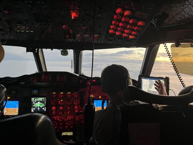
Buckle up, this will be a bumpy ride! 🛩️ 🌨️
Scientists with @nasa IMPACTS took off from @NASA_Wallops and flew straight into snowstorms to learn how clouds form. ☁️
Read about what it's like onboard: go.nasa.gov/40ztmc1
#NASAEarth
Got your head in the clouds this weekend? Us too. ☁️😊☁️
This time-lapse video shows open-celled and closed-cell marine stratocumulus clouds. Imagery is from @noaa’s GOES-17 satellite, which @nasa helped develop and launch.
More: go.nasa.gov/3X2Jxf3
#NASAEarth
Ex-cell-ent Clouds off Chile’s Coast
Satellites have exposed the impressive coverage of marine stratocumulus clouds as well as their compelling shapes and patterns.go.nasa.gov
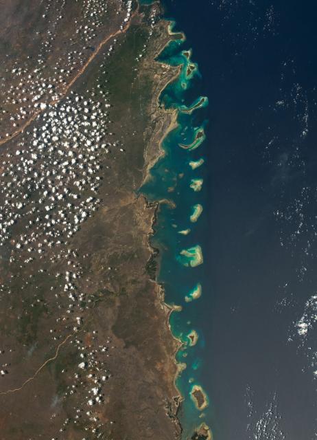
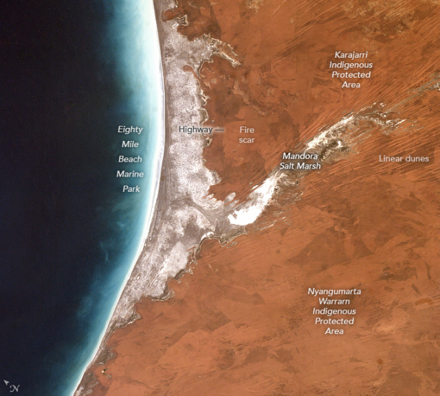
A meeting of two worlds 🌊🐦
The waters off Australia’s famed Eighty Mile Beach are inhabited by whales, dolphins, and dugongs, while its sandy coastline is one of Australia’s most important environments for migratory shorebirds. go.nasa.gov/3YbUWtP
#NASAEarth
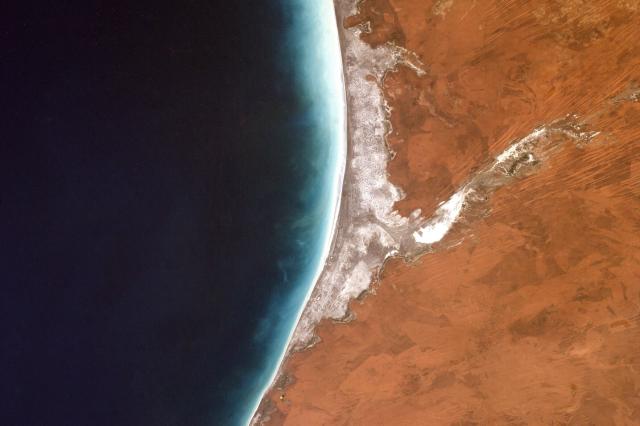
Eighty Mile Beach
This stretch of coastline in Western Australia is a popular recreational site for people and an important stopover site for migratory birds.go.nasa.gov
#NASAEarth
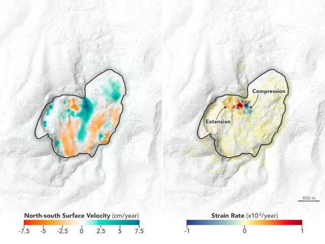
In eastern Congo, a large, slow-moving landslide is accelerating and putting a community at risk. A new NASA study using satellite data shows how changing water usage in the city of Bukavu influences land movements near and just below the surface.
More: go.nasa.gov/3HWeEob
#NASAEarth
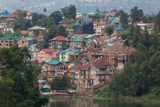
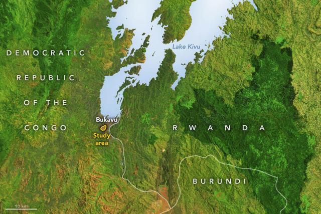
Scientists Track Tropical Landslide Creeping Below an African City
A large, slow-moving landslide is accelerating in eastern Congo, putting a community at risk. New research exposes geologic hazards amid unprecedented urban sprawl.Tony Greicius (NASA)
#NASAEarth
NASA’s Terra and Aqua satellites helped meteorologists determine that marine stratocumulus clouds are relatively common.
On average, they cover ~15% of Earth’s total surface.
#NASAEarth
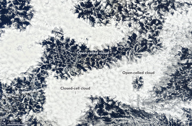
Organized marine stratocumulus clouds, found in the subtropics and midlatitudes, take two forms; open-celled and closed-cell.
Recent studies have found that smoke, dust, and aerosols can affect the formation of open- and closed-cell clouds.
Full story: go.nasa.gov/3DDJVtI
#NASAEarth
Ex-cell-ent Clouds off Chile’s Coast
Satellites have exposed the impressive coverage of marine stratocumulus clouds as well as their compelling shapes and patterns.go.nasa.gov
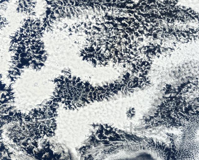
Hope you don't have your head in the clouds, because it's time for a pop quiz!
What kind of clouds are these?☁️
#NASAEarth

These images show roughly the same area in false-color to better distinguish water (blue) and land (brown and green).
The left image shows more typical conditions; the right image is from after the storm.
#NASAEarth
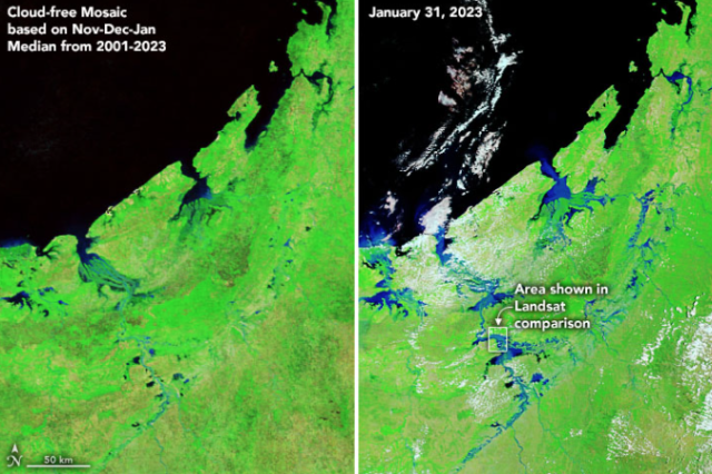
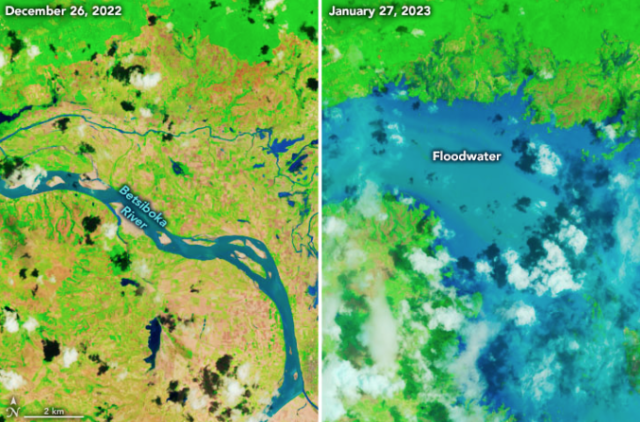
Heavy rain from Tropical Cyclone Cheneso caused flash floods and landslides along Madagascar’s northwestern coast. 🌧️
This @nasa satellite image shows brown sediment-laden floodwater pouring toward the Mozambique Channel. go.nasa.gov/3JwMst6
#NASAEarth
Cheneso Floods Madagascar
Heavy rain from the tropical cyclone triggered flash floods and landslides along the island nation’s northwestern coast.go.nasa.gov
#NASAEarth


NASA and IBM Collaborate to Apply AI to Earth Science Data
Space Act Agreement between NASA and IBM will apply artificial intelligence (AI) foundational models to NASA Earth observation data.Josh Blumenfeld (Earthdata)
Did you get it right?
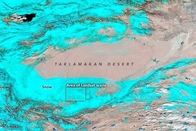
The #Landsat 9 images show a snow-covered desert landscape and sand dunes near the Keriya River in the Xinjiang region of western China, taken after a powerful winter storm earlier this month. ❄️go.nasa.gov/3JvzlZu
#NASAEarth
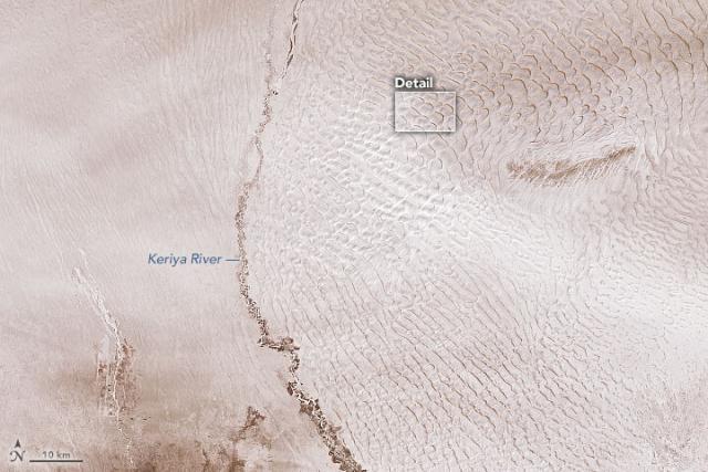
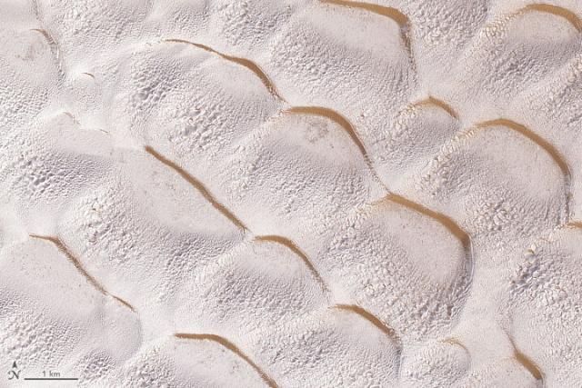
Wintry Dunes on Earth and Mars
Dunes on both planets occasionally get blanketed with ice and snow—except on Earth the white stuff is frozen water and on Mars it’s often frozen carbon dioxide.go.nasa.gov
#NASAEarth