Search
Items tagged with: nasaearth
Climate change may be affecting our health in surprising ways, from spreading insect-borne diseases, like malaria, to worsening seasonal allergies. NASA satellites and data help us study these public health threats and reduce their impacts.
Details: go.nasa.gov/3q1a8y6
#NASAEarth
When Climate Gets Under Your Skin
From insect-borne diseases to seasonal allergies and “superbugs,” climate change is quite literally getting under our skin, affecting our health in often surprising ways.Climate Change: Vital Signs of the Planet
It’s all about connections!
TROPICS, launching soon, will study how storms in the tropics form and help us understand how storms are connected to Earth’s water cycle, long-term climate trends, and other Earth systems. go.nasa.gov/3q92aDi
#NASAEarth
NASA, Rocket Lab Announce Coverage for Second TROPICS Launch
After successfully launching the first pair of small satellites earlier this month from New Zealand, NASA and Rocket Lab are now targeting no earlier than 1:30 a.m. EDT Monday, May 22 (5:30 p.m.Roxana Bardan (NASA)
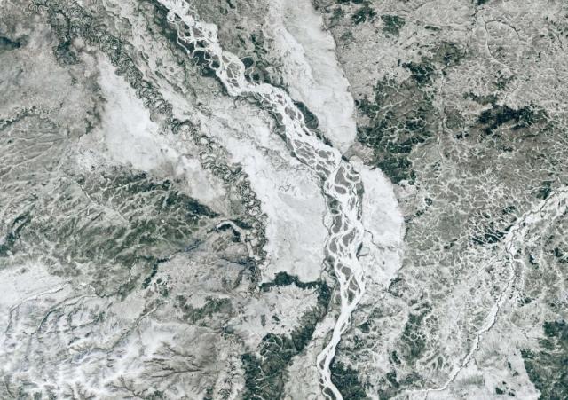
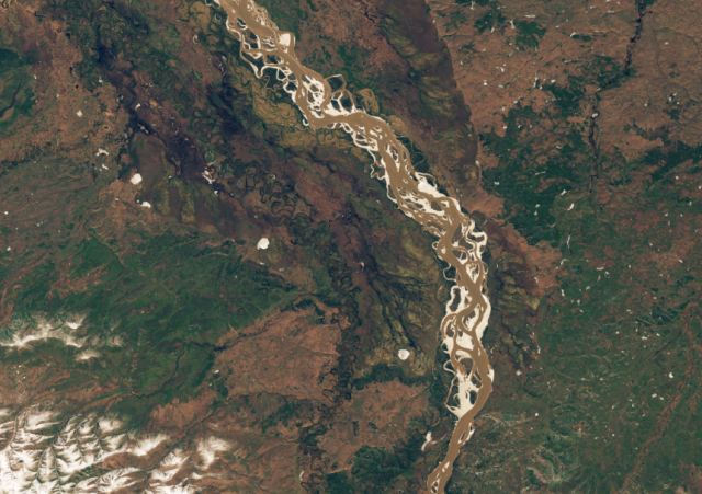
Melting winter snowpack and river ice breaking up caused damaging floods along Alaskan rivers in May 2023. go.nasa.gov/3Ww0PlX
These #Landsat images show the Yukon River transforming from a frozen, snowy landscape to a thawed one in just 8 days.
#NASAEarth
A Tumultuous Spring Breakup
Rapid thawing in Alaska caused damaging river floods in May 2023.go.nasa.gov
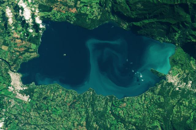
Toxic algae blooms are becoming more frequent in some lakes, including Chile’s Lake Villarrica seen in this #Landsat image.
The blooms are likely caused by warmer surface waters and nutrient-laden runoff from urban or agricultural areas. go.nasa.gov/423UHCA
#NASAEarth
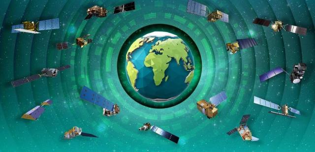
This week @nasa @esa & @jaxa_en received the IAF Special Award for the Earth Observing Dashboard, which shows changes in Earth’s air, land and water.
Explore the dashboard: eodashboard.org/
#NASAEarth
Earth Observing Dashboard
The Earth Observing Dashboard combines the resources, technical knowledge and expertise of three partner agencies ESA, JAXA, and NASA to strengthen our global understanding of the changing environment with human activity.Earth Observing Dashboard
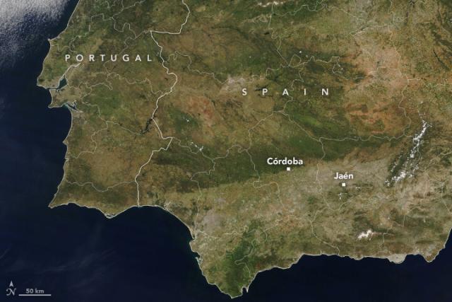
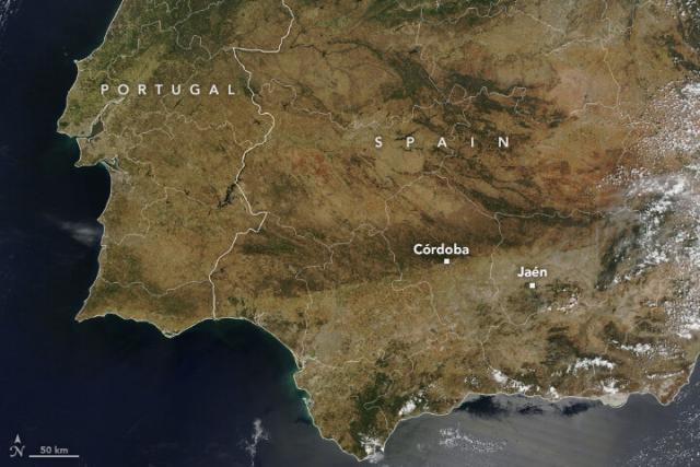
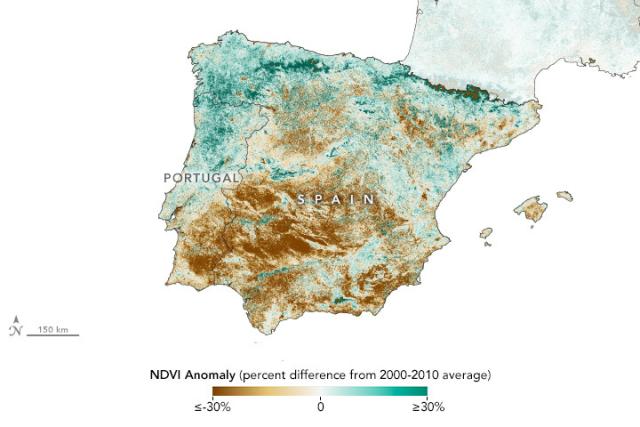
In Spain, a drought turns the world’s largest olive oil producing region brown.
NASA’s Terra satellite shows where green vegetation in May 2022 (left) turned brown by May 2023 (right). The drought dried up reservoirs, parched olive groves, and led to water restrictions.
#NASAEarth
#NASAEarth
Spain Browned by Drought
Unseasonable heat and meager rainfall parched the world’s largest olive oil producing region in spring 2023.go.nasa.gov
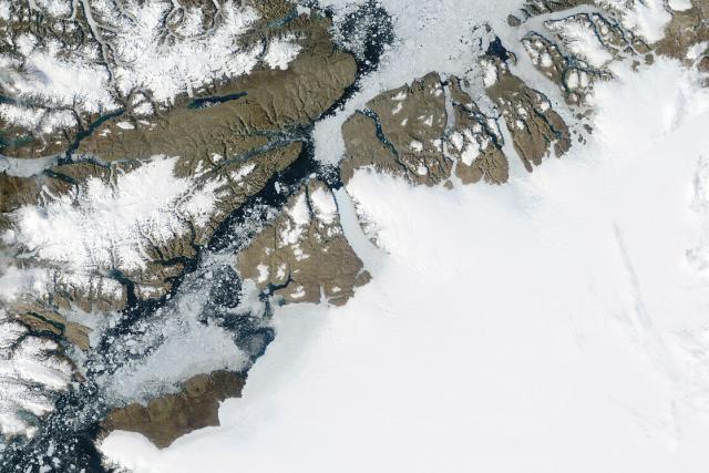
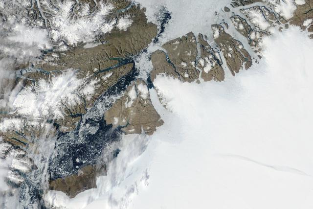
Petermann Glacier, one of Greenland’s largest glaciers that ends at the ocean, is thinning, retreating, and its flow is accelerating.
These satellite images show the glacier in August 2002 (left) and 2022 (right). go.nasa.gov/43bj6ra
#NASAEarth
Retreat at Petermann Glacier
Decades of retreat are visible from above, but harder-to-see changes below the waterline could also affect this iconic glacier’s future.go.nasa.gov
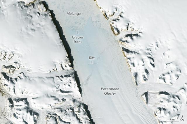
As the glacier stretches and thins, it becomes more prone to rifts that can break and form icebergs.
This @nasa @usgs #Landsat 8 image shows a rift on the floating ice tongue, acquired on May 14, 2023. go.nasa.gov/43bj6ra
#NASAEarth
Retreat at Petermann Glacier
Decades of retreat are visible from above, but harder-to-see changes below the waterline could also affect this iconic glacier’s future.go.nasa.gov
#NASAEarth
Earth is rich with biodiversity. 🌱 🦜
But deforestation, land use changes, and climate change are affecting global ecosystems. NASA works with partners worldwide to help them monitor biodiversity changes in near real-time and understand the impact. go.nasa.gov/421cASK
#NASAEarth
A Global Biodiversity Crisis: How NASA Satellites Help Track Changes to Life on Earth
Climate change plays an increasing role in the global decline of biodiversity—the variety of life on Earth.Climate Change: Vital Signs of the Planet
As winter turns to spring, snow is melting across the Northern Hemisphere. ❄️ ➡️ 💧
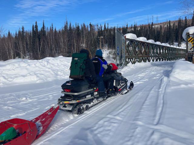
Earlier this year, scientists with @nasa’s SnowEx mission were studying snow in Alaska to understand how much water the snow contains. go.nasa.gov/3IyaFyd
#NASAEarth
The Science of Snow: Digging for Data
It takes a lot of field work in challenging conditions to gather important snow data. This is the story of NASA’s last SnowEx campaign and those who particip...YouTube
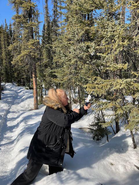
Time to wake up, boreal forests 🌲
Scientists with @nasa’s ABoVE project traveled to Alaska in April 2023 to investigate ways to use satellite data to study boreal forests productivity and stress.
Follow their adventures: go.nasa.gov/45hghpZ
#NASAEarth
Notes from the Field - Illuminating a Boreal Forest’s Spring Wake-Up
climate change, global climate change, global warming, natural hazards, Earth, environment, remote sensing, atmosphere, land processes, oceans, volcanoes, land cover, Earth science data, NASA, environmental processes, Blue Marble, global mapsgo.nasa.gov
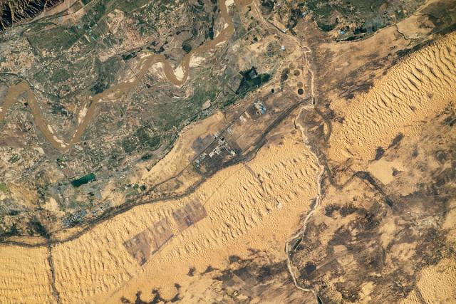
Dunes along the Yellow River 💛
An astronaut on the @Space_Station captured this photo of the Yellow River floodplain in northern China, which has a dune field made of sand from the Yellow River. go.nasa.gov/3BDs9VY
#NASAEarth
Dunes Along the Yellow River
Dunes, crops, roads, and solar farms flank the river as it winds through China’s Inner Mongolia.go.nasa.gov
Climate change is causing rising sea levels, longer and more intense heat waves, melting ice, extreme weather events and more.
But there are other, often surprising, ways Earth’s changing climate is affecting our world. 🧵 go.nasa.gov/3pNh4Pg
#NASAEarth
Planes, Shipping Lanes, and Automobiles
A new NASA Climate feature series examines some of the lesser-known, and often surprising, ways global climate change is affecting our world. First up: transportation.Climate Change: Vital Signs of the Planet
Climate change may make airline flights bumpier. 🛩️
Climate change may strengthen vertical wind shear in jet streams – creating irregular air motions, or turbulence. Pilots use or avoid jet streams to make flights more efficient.
#NASAEarth
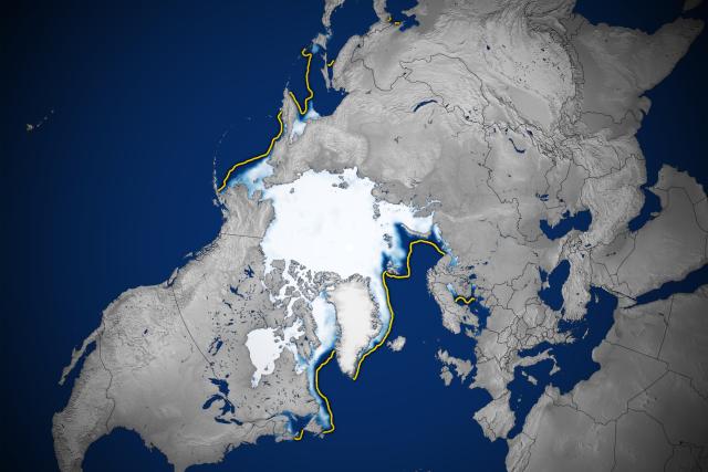
As Arctic sea ice melts due to climate change, sailing through the Arctic Ocean could become easier and shorten travel times.
However, traveling over sea ice using snowmobiles, trucks or other vehicles could become unsafe as the ice thins. 🧊
#NASAEarth
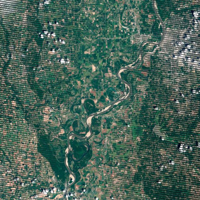
Climate change is expected to increase the frequency and intensity of droughts and floods.
Water levels in rivers and reservoirs could shift drastically, impacting cargo ships. 🚢 go.nasa.gov/3pNh4Pg
#NASAEarth
Planes, Shipping Lanes, and Automobiles
A new NASA Climate feature series examines some of the lesser-known, and often surprising, ways global climate change is affecting our world. First up: transportation.Climate Change: Vital Signs of the Planet
“We always describe water as the artery of life."
Through the @GLOBEProgram, NASA is helping create a global network of student and citizen scientists. In Oman, students are working on issues affecting local farmers, such as low water levels and soil salinity.
#NASAEarth
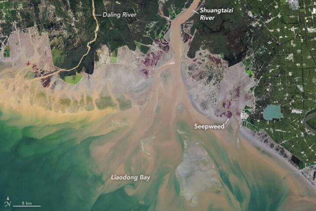
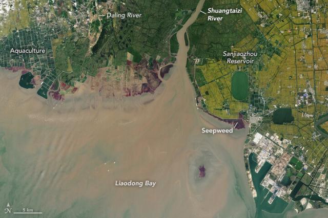
These #Landsat images show the same estuary in northeastern China 36 years apart.
A salt-loving seepweed turns the coast a deep red in the fall, which highlights how the estuary has changed due to coastal developments from 1986 (left) to 2022 (right). go.nasa.gov/3oen6YS
#NASAEarth
A Changing Estuary Lined With Red
Satellite observations of seepweed are helping scientists track how these treasured, colorful plants are faring as coastal landscapes in northeastern China change.go.nasa.gov
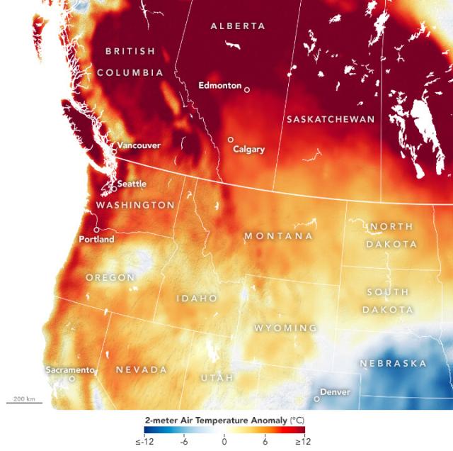
Summer temperatures came early to the western U.S. and Canada 🥵
This map shows the difference between air temperature during the heatwave and the 2014-2022 average (higher temps in red) according to the @nasagoddard GEOS model. 🌡️ go.nasa.gov/42MkjoF
#NASAEarth
Summer Temperatures Arrive Early
Record-breaking heat stifled western U.S. states and Canadian provinces.go.nasa.gov
NASA 🤝 @forestservice
Mapping America’s oldest trees 🌲
The team created the first-ever inventory of mature and old-growth forests in the U.S. using boots-on-the-ground research and @nasa’s GEDI instrument on the @Space_Station.
More: go.nasa.gov/433bsiq
[Video embedded in original tweet]
#NASAEarth

NASA Teams with Forest Service to Tally America’s Oldest Trees
The White House has called for an inventory of our eldest forests. A space instrument is helping scientists chronicle these trees as a changing climate threatens their future.Jennifer Fadoul (NASA)
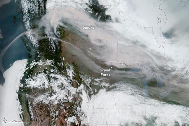
As of May 16, fires have scorched 478,000 hectares (1,800 square miles) in southern Canada – 10-times the average area burned for this time of year.
@noaa's GOES-18 satellite captured smoke from the fires over Canada and the U.S. on May 15, 2023. go.nasa.gov/45l4KGu
#NASAEarth
Smoke Fills North American Skies
Smoke from wildland fires caused poor air quality and hazy skies in several cities.go.nasa.gov
Better together. 🤝
NASA and USAID’s @SERVIRGlobal make Earth data more accessible and useful. They co-developed tools with scientists in Southeast Asia to help predict extreme rainfall, track reservoir levels, and monitor heavy smoke and pollution.
Satellite Data, Applications Flowing Through SERVIR to Southeast Asia
ith customized tools that use NASA observations and data, the people who manage the Mekong River water supply have been improving their decision-making.Beth Ridgeway (NASA)
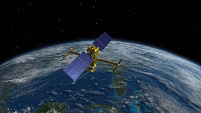
Launched in December 2022, @nasa's SWOT satellite will make the first global survey of Earth's surface water. 🌊 🛰️
Hear SWOT's up with the mission from @NASAJPL scientist Parag Vaze on NASA's Small Steps, Giant Leaps podcast. go.nasa.gov/3pOJZm0
#NASAEarth
Small Steps, Giant Leaps: Episode 106: Surface Water and Ocean…
Surface Water and Ocean Topography Project Manager Parag Vaze discusses the first global survey of Earth's surface water.Maria Berger (NASA)
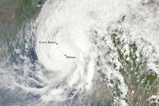
Cyclone Mocha reached category 5 status before making landfall just north of Sittwe, Myanmar, bringing dangerous winds, downpours, and storm surge.
NASA’s Aqua satellite captured this image of the cyclone on May 14. go.nasa.gov/3pOhF3a
#NASAEarth
Cyclone Mocha Strikes Myanmar
The storm reached category 5 status before barreling into the state of Rakhine.go.nasa.gov
Busy as a beaver. 🦫
Cindy Schmidt’s journey from an urban planner to a career in remote sensing and geographic information systems is anything but ordinary.
Learn about her journey at NASA: go.nasa.gov/3MmtmqT
#NASAEarth
Cindy Schmidt: Finding A Career in Remote Sensing and Geographic Information Systems | NASA Applied Sciences
Science mentor, world traveler, remote sensing teacher, research scientist, andgo.nasa.gov
Two NASA studies find that methane emissions dropped for several years in the Los Angeles Region.
The studies used different approaches to measuring the powerful greenhouse gas – with ground-based sensors and an airborne instrument. go.nasa.gov/3Btxjnm
#NASAEarth
Two NASA Studies Find Lower Methane Emissions in Los Angeles Region
Researchers found that emissions of the powerful greenhouse gas dropped for several years near the nation’s second-largest metropolitan area.Tony Greicius (NASA)
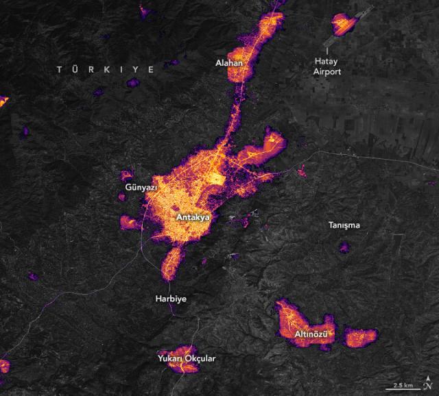
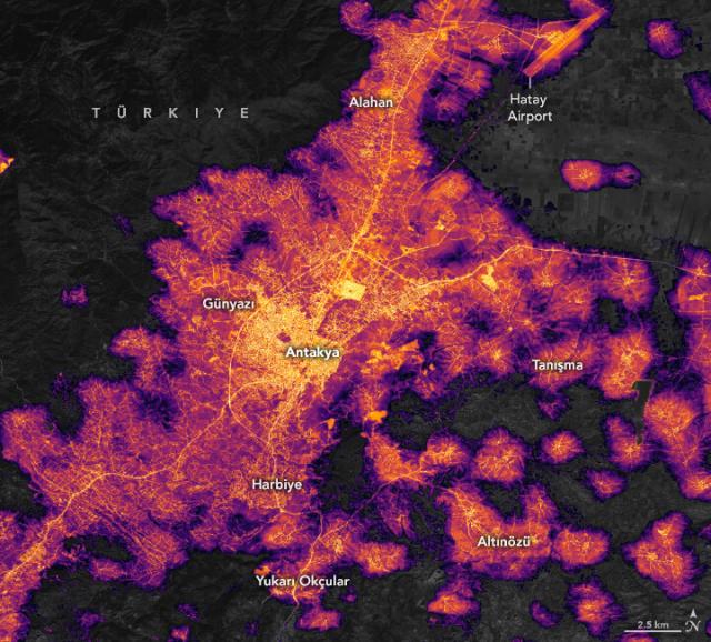
Lights are steadily returning to southeast Türkiye after deadly earthquakes triggered power outages in February 2023.
These maps show nighttime lights detected near Antakya just after the quake (Feb. 8, left) and on April 30 (right). go.nasa.gov/3MsAJNv
#NASAEarth
Brighter Nights in Antakya
Lights have been steadily returning to southeast Türkiye after deadly earthquakes triggered power outages in February 2023.go.nasa.gov
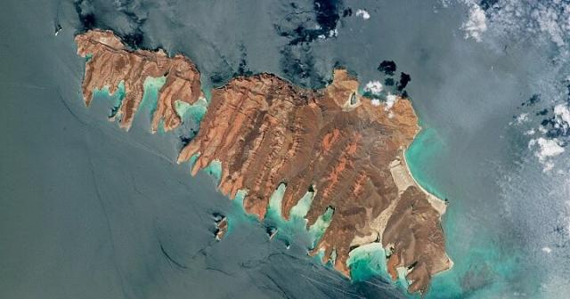
Black lava and pink ash from volcanic and tectonic activity make these two Gulf of California islands appear rust-colored in this photograph taken by a @Space_Station astronaut. 🌋
The two large islands are Isla del Espíritu Santo and Isla La Partida. go.nasa.gov/3nXxxQj
#NASAEarth
Espíritu Santo Archipelago
The island group off Mexico’s Baja California Sur has eroded slowly, preserving evidence of past human activity.go.nasa.gov
What could you make with 8 crayons? What about a box of 96 or 128? 🖍️
@nasa’s PACE satellite, slated to launch in 2024, will see ocean color in more shades than any other sensor, helping scientists unlock the secrets of the sea. 🌊 🛰️
go.nasa.gov/41v5CFo
#NASAEarth
A Sea of Data: The PACE Mission
The data from PACE (Plankton, Aerosol, Cloud, ocean Ecosystem) will help us better understand how the ocean and atmosphere exchange carbon dioxide. In additi...YouTube
#NASAEarth
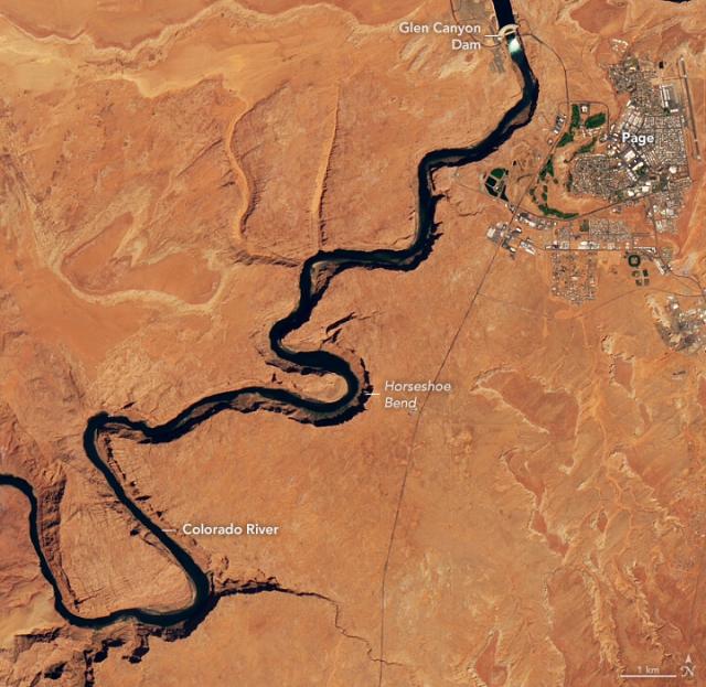
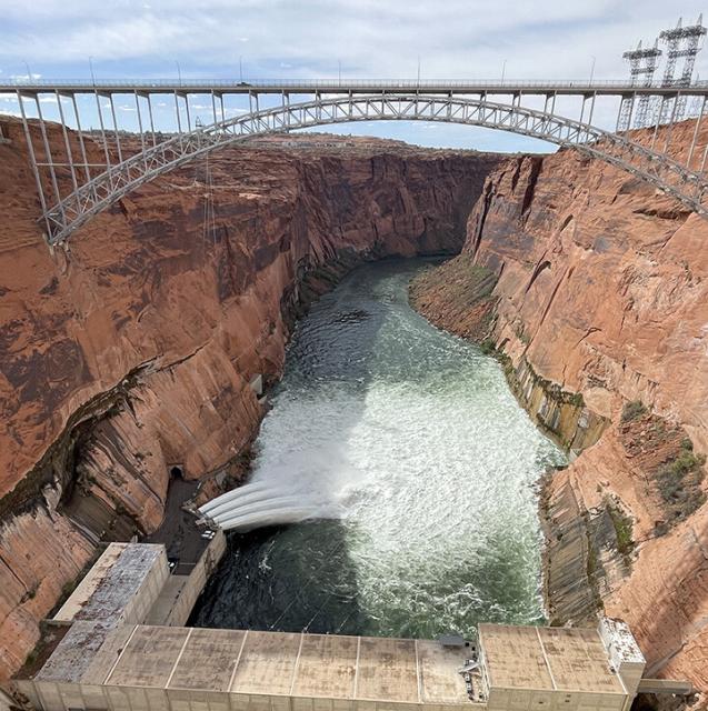
High Flow at Glen Canyon Dam
Water managers released a surge of water from the dam in late April to help preserve shrinking sandbars and shoreline habitats downstream.go.nasa.gov
In the coming weeks, @USGS and @NatlParkService teams will document exactly where and how much sediment has moved based on data collected by remote cameras, fieldwork, and small aircraft.
Photo courtesy of @usbr.
Read more: go.nasa.gov/42Sdkdy
#NASAEarth
High Flow at Glen Canyon Dam
Water managers released a surge of water from the dam in late April to help preserve shrinking sandbars and shoreline habitats downstream.go.nasa.gov
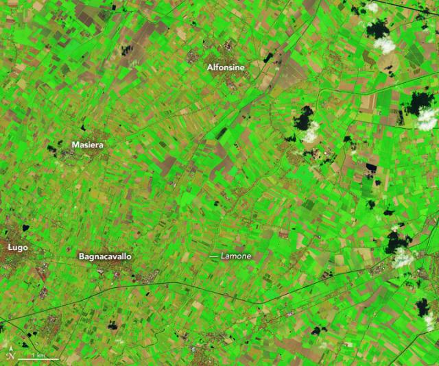
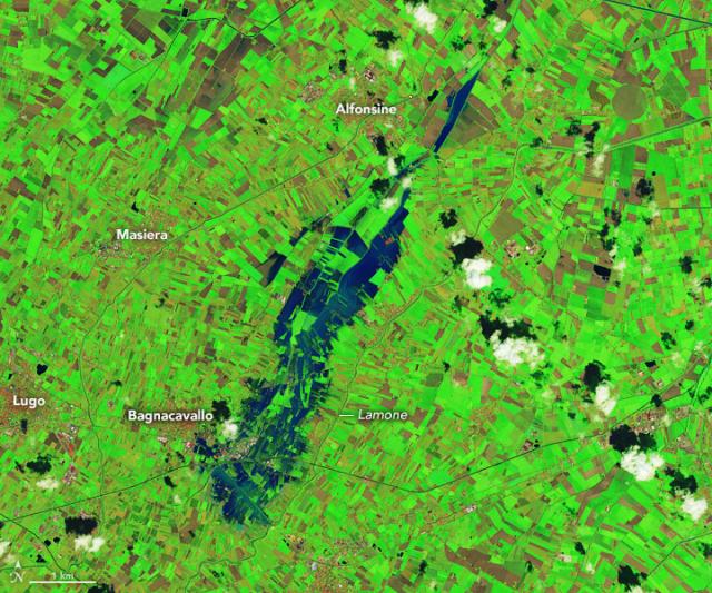
Heavy rains caused flash flooding and landslides in northern Italy on May 2–3, 2023. 🌧
#Landsat satellites captured these enhanced-color images of flooding near the Lamone river before (left) and after (right) the rains. go.nasa.gov/3LPXWaO
#NASAEarth
A Deluge in Italy
Heavy rains caused destructive flash flooding in the Emilia-Romagna region.go.nasa.gov
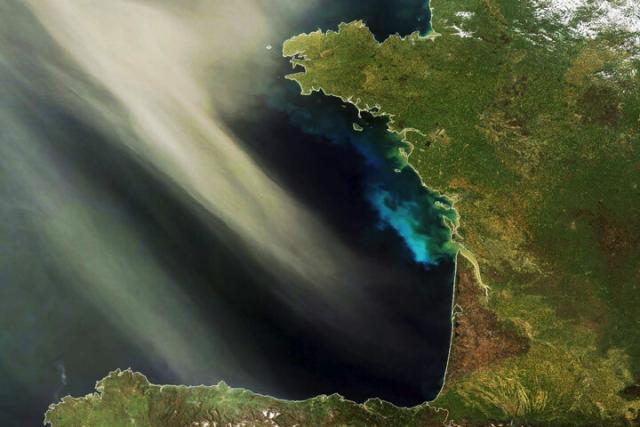
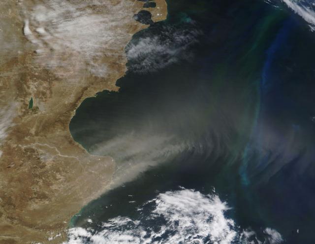
DustDash order for phytoplankton 🌬️
A new study shares how dust – carried from land over the ocean by winds – nourishes tiny, plant-like marine organisms called phytoplankton. Phytoplankton play a large role in Earth’s climate and carbon cycle. go.nasa.gov/3MkRx9c
#NASAEarth
How Desert Dust Nourishes the Growth of Phytoplankton at Sea
After a long-distance delivery, nutrients in desert dust nourish life in the ocean.Jennifer Fadoul (NASA)
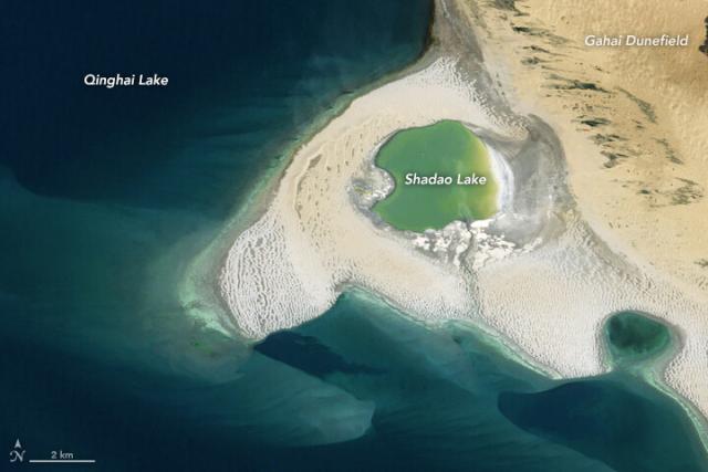
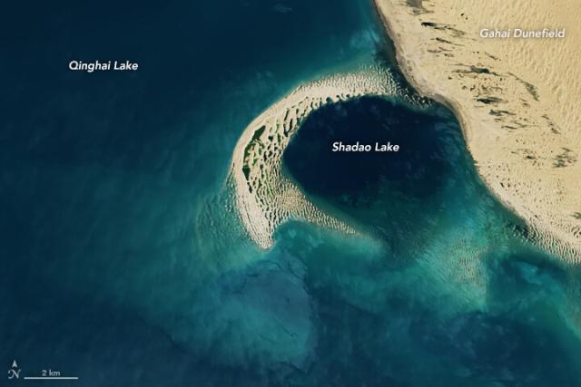
The shape of western China’s Qinghai Lake changes as the region’s climate shifts, researchers say.
As water levels drop due to warming trends, dunes build up and divide the lake into several sub-lakes, like Shadao Lake in these #Landsat images. go.nasa.gov/3nHiB9b
#NASAEarth
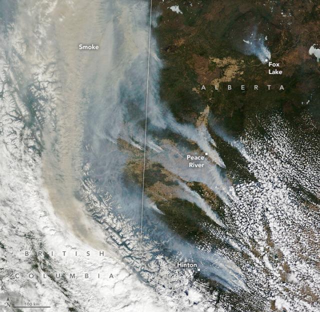
Over 100 wildland fires raged across Western Canada in early May 2023, prompting widespread evacuations and chimneys of smoke that reached the troposphere.
@nasa’s Terra satellite captured this image on May 6. go.nasa.gov/3NWr2YG
#NASAEarth
Fires Scorch Western Canada
Raging fires destroyed homes in Alberta and produced towering chimneys of smoke.go.nasa.gov
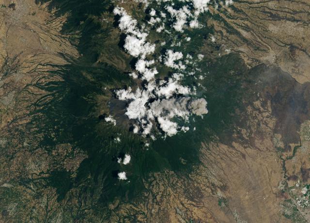
Popocatépetl is one of Mexico’s most active volcanoes. 🌋
Its current eruption has been ongoing since 2005. In spring 2023, both #Landsat 8 (left) and @Space_Station astronauts (right) captured images of the volcanic plumes. go.nasa.gov/3nExl8y
#NASAEarth
Popocatépetl Volcano Keeps on Puffing
One of Mexico’s most active volcanoes continues to put on a show for satellites and astronauts.go.nasa.gov
Noctiluca scintillans algae blooms can soak up all the oxygen in the water, killing fish and coral.
Researchers suspect that higher water temperatures due to climate change could be responsible for more frequent and intense blooms. go.nasa.gov/42xvhhx
#NASAEarth
Deadly Blooms in the Gulf of Mannar
Though Noctiluca scintillans blooms have long been noted in the shallow gulf, they have become more frequent and intense since 2019.go.nasa.gov

