Search
Items tagged with: nasaearth

go.nasa.gov/40sz8uL
#NASAEarth
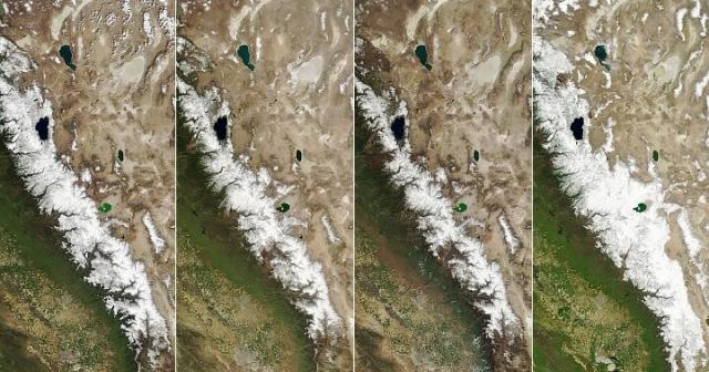
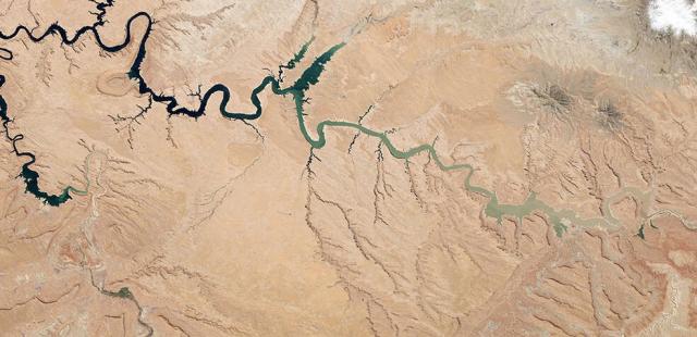
A Boom Year for Sierra Nevada Snow
Atmospheric rivers delivered a huge amount of snow to the California mountain range.go.nasa.gov

👋 Wave clouds over the Crozet Islands.
The mountainous islands disrupt the flow of air, which can have a ripple-like effect on the clouds. An astronaut aboard the @Space_Station captured this image earlier this year.

Wave Clouds Over the Crozet Islands
The mountainous islands in the South Indian Ocean disrupt the flow of air, which can have a ripple-like effect on the clouds.go.nasa.gov
#NASAEarth

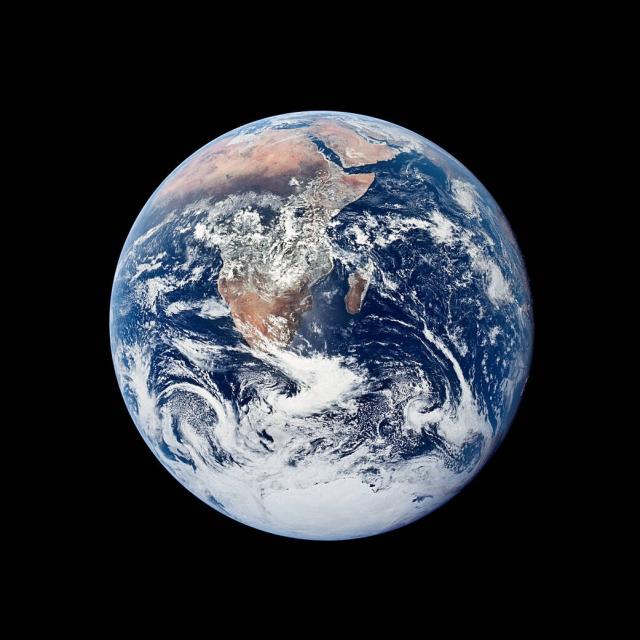
Earth is our home. 💚
On #EarthDay and every day, we’re learning more about our world and how it’s changing – giving us a deeper appreciation for the planet we call home.
Celebrate with us: go.nasa.gov/3mZmeXx
#NASAEarth
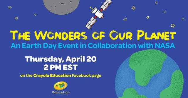
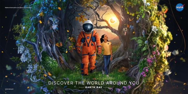
Earth Day 2023
NASA.gov brings you the latest images, videos and news from America's space agency. Get the latest updates on NASA missions, watch NASA TV live, and learn about our quest to reveal the unknown and benefit all humankind.NASA
From mapping coral habitats to promoting greater collaboration, #OpenScience is transforming @nasa research and protecting our planet.
Here are 5 ways it's making an impact: go.nasa.gov/3GYVIEg
#NASAEarth
5 Ways TOPS is Transforming NASA Research and Protecting Our Planet
In celebration of Earth Day, it's important to recognize the role of open science in protecting our planet and advancing NASA's research efforts.Beth Ridgeway (NASA)
🌎 LIVE NOW: NASA’s Virtual #EarthDay event!
Tune in from 1-3pm ET to hear from NASA experts, play trivia games, and learn more about how and why @nasa studies Earth. Join us: Go.nasa.gov/NASAScienceNow
#NASAEarth
Pops of Poppies 🌼🌼
After California’s particularly wet winter: a sea of wildflowers. Orange, gold, and yellow flowers flood the valleys and hills of Antelope Valley California Poppy Reserve in this image by #Landsat 8.
Where are flood waters flowing after major storms? How much did the land move during an earthquake or volcanic eruption? OPERA, a @NASA-led project, is helping make Earth data from multiple satellite missions more accessible.
Get the details: go.nasa.gov/43Pr0Hx
#NASAEarth
NASA-Led Project Tracking Changes to Water, Ecosystems, Land Surface
Merging data from multiple satellites, OPERA can help government agencies, disaster responders, and the public access data about natural and human impacts to the land.Tony Greicius (NASA)
#NASAEarth
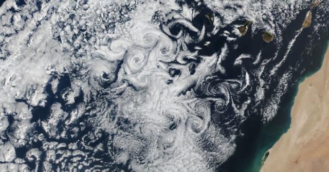
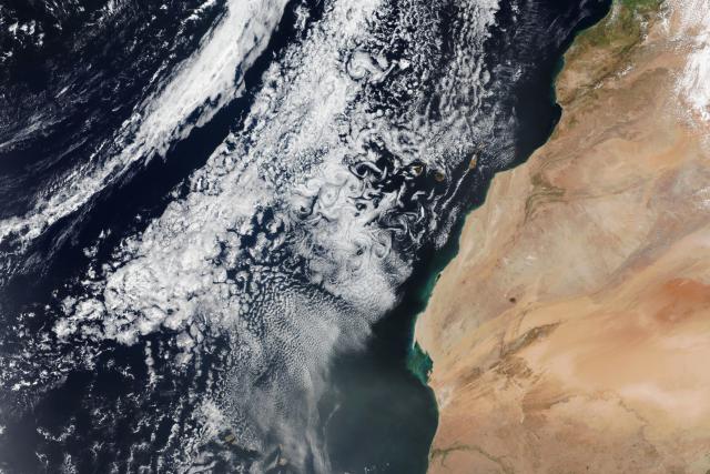
Swirly Clouds in the Canaries
Cloud vortices leave a fingerprint of atmospheric motion near the Canary Islands.go.nasa.gov
Every day @nasa is learning something new about our home planet. Marvel at the world around you and discover your place in space with this year’s #EarthDay poster.
🌎 Download and start discovering: go.nasa.gov/41x22e8
#NASAEarth
Earth Day Posters & Downloadables | Science Mission Directorate
This is a collection of illustrated posters in NASA's annual celebration of Earth Day. High resolution printable PDF files are available for download by clicking on each image.go.nasa.gov
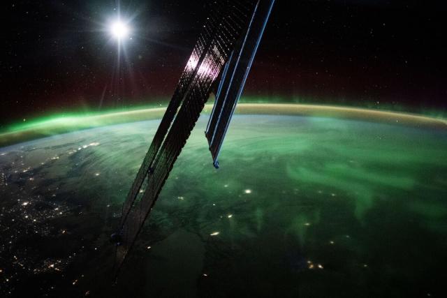
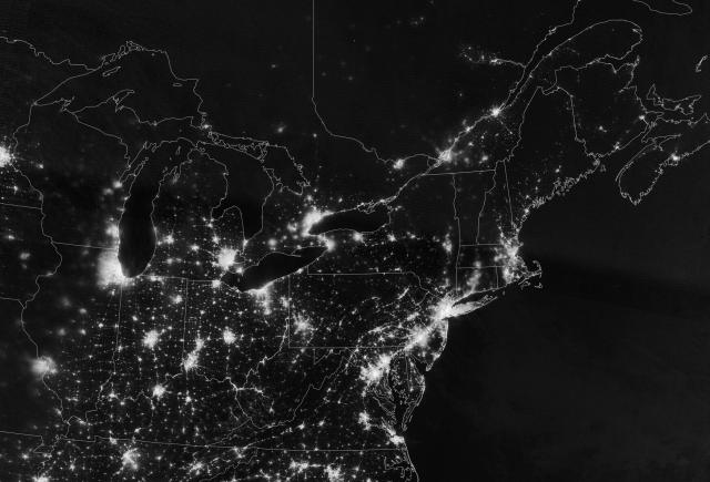
Earth at night. 🌏🖤
Dark skies help us see the brilliant color of auroras, pinpoint constellations and other planets in the night sky, and are important for the health of plants, insects, animals, and humans. #DarkSkyWeek
#NASAEarth
#NASAEarth
Scientists compared nighttime lights seen by NASA satellites and @cdc health data.
They found that poorer, non-white neighborhoods experience more artificial light at night, which can disrupt circadian rhythms and cause sleep deficiency. #DarkSkyWeek
go.nasa.gov/3nBnuQx
#NASAEarth
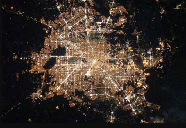
Brighter Neighborhoods Harm Human Health | NASA Applied Sciences
A newly emerging field of study is connecting the bright lights of U.S. cities at night to poorer human health.go.nasa.gov
Want to @DoNASAScience from your own backyard? Join a citizen science project. 👩🔬🌎
Help map penguin populations, report landslides around you, record your observations of trees and clouds, and more!
Get started: science.nasa.gov/CitizenScienc…
#NASAEarth
Citizen Science | Science Mission Directorate
Opportunities to help NASA by doing cutting-edge research together with NASA scientists.science.nasa.gov
Heavy rains overtopped the banks of the Shabelle and Juba rivers, affecting hundreds of thousands of people in Ethiopia and Somalia. NASA’s Terra satellite captured flooding in this enhanced-color image which makes the water, in dark blue, stand out.
🔗 go.nasa.gov/3A38aPs
#NASAEarth
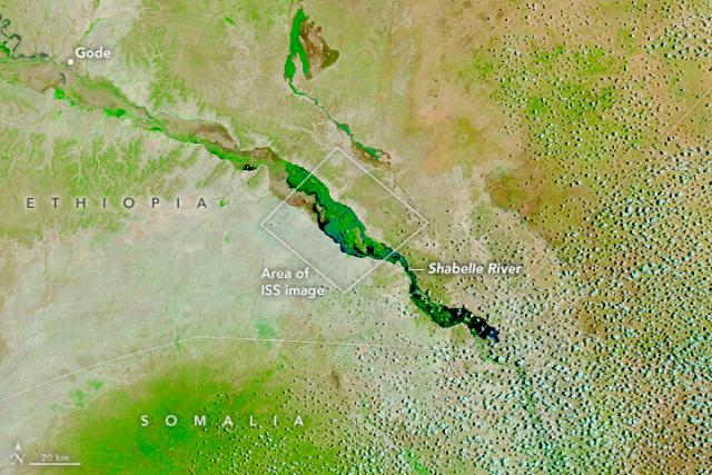
Heavy Rains Hit Drought-Stricken Horn of Africa
Water overtopped the banks of the Shabelle and Juba rivers, affecting hundreds of thousands of people in Ethiopia and Somalia.go.nasa.gov
Learning about the past, looking to the future.
Through The @GLOBEProgram, NASA is helping create a global network of student and citizen scientists who are monitoring how Earth is changing and making an impact in their communities. Watch their stories: youtu.be/hglfRAUaA1U
#NASAEarth
Agents of Change -- The Trailer
The GLOBE Implementation Office set out to tell the story of how The GLOBE Program impacts people and communities around the world. Throughout the worldwide ...YouTube
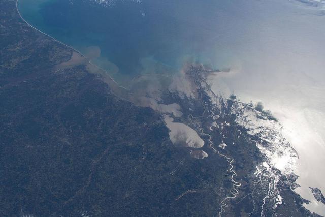
The dark landmass of Rennell Island, part of the Solomon Islands, and its raised coral reef stand out against the bright sunglint on the Pacific Ocean and Lake Te Nggano in this astronaut photo taken from the @Space_Station.
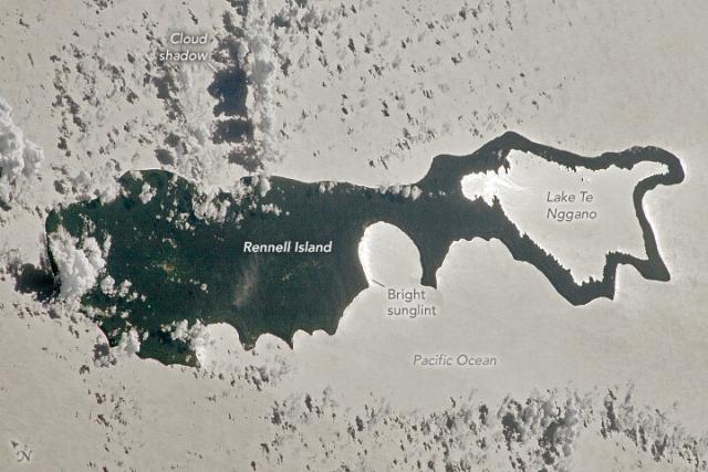
Silhouette of a Solomon Island
The dark shape of Rennell Island, including its raised coral atoll, stands out amid the sunglint.go.nasa.gov
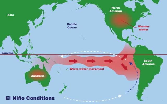
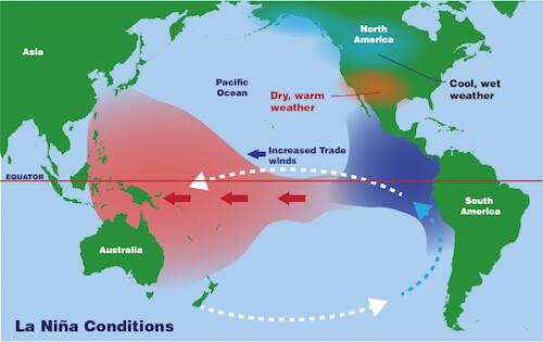
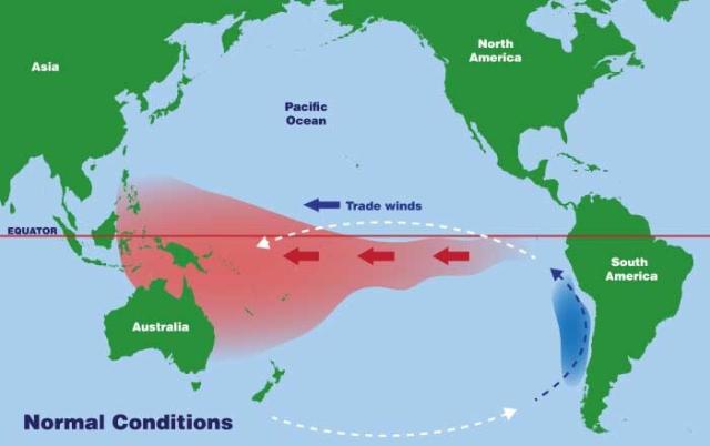
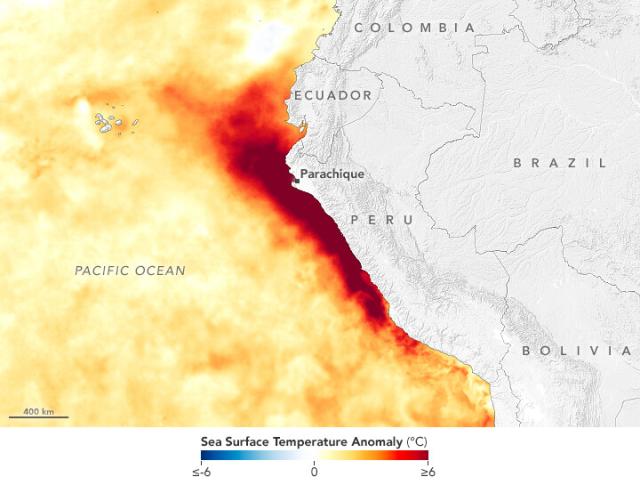
ENSO is a complicated climate pattern.
Sea surface temperature, trade winds, atmospheric coupling and more are all factors in the El Niño Southern Oscillation.
#NASAEarth
Tropical Cyclone Ilsa made landfall in Western Australia around midnight local time on April 13, 2023.
The @nasa @noaa Suomi NPP satellite captured this image about 10 hours prior. go.nasa.gov/3KY2j4s
#NASAEarth
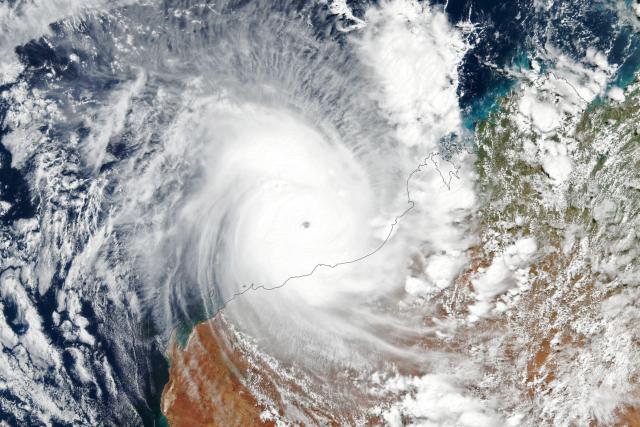
Cyclone Ilsa Reaches Western Australia
In April 2023, the cyclone became one of the most potent storms to hit the Pilabra region in recent years.go.nasa.gov
#ICESat2 fires 10,000 laser pulses a second, sending six green beams of light toward Earth.
Scientists can measure the height of ice, oceans, trees and more based on how long it takes those beams to bounce off Earth and return to the satellite. go.nasa.gov/6851
[Video embedded in original tweet]
#NASAEarth
Got #EarthDay plans? Join us from wherever you are. 🌎
From space to the ground, NASA’s Earth missions help us discover more about our planet every day.
Celebrate with us in person, with online videos and games, or by joining a citizen science project: go.nasa.gov/3oduXpm
#NASAEarth
NASA Celebrates Earth Day with Earth Science in Action
This Earth Day, you can join us in person and online to see how our observations help us monitor the planet’s vital signs and share them with scientists and citizens around the world.Jennifer Fadoul (NASA)
B-22A has set sail. 🧊
The iceberg is the largest remaining piece of a massive berg that broke off Thwaites Glacier in 2002. This animation of satellite images shows B-22A drifting about 175 kilometers (110 miles) in about six months. go.nasa.gov/401kXfT
#NASAEarth
Long-Lived Iceberg Sails Away
An enormous iceberg located off the Antarctic coast for more than two decades finally started moving out to sea in late 2022.go.nasa.gov
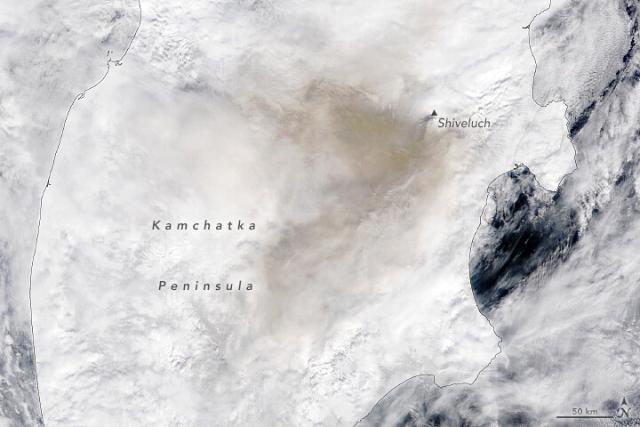
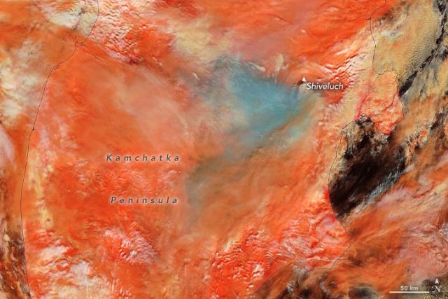
Two major eruptions on Russia’s Kamchatka Peninsula blasted volcanic material into the stratosphere within the same week.
The first erupted on April 7, captured in this image by #Landsat 8, with a second, more powerful eruption on April 10. go.nasa.gov/43qAvg6 🌋 🌋
#NASAEarth
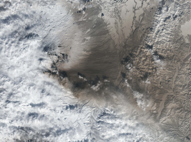
Kamchatka Erupts
Two powerful eruptions from the peninsula in northeastern Russia sent volcanic material soaring.go.nasa.gov
The Shiveluch volcano erupted on April 10, sending a plume of ash and smoke anywhere from 10-20 kilometers (about 6-12 miles) high.
It’s hard to distinguish clouds from snow in the satellite image (left). The enhanced-color (right) shows snow in orange and ash in blue/gray.
#NASAEarth
... Ready For It?
Our satellites can't see someone driving a Getaway Car, but we do get Gorgeous images of Earth at night that help us track nighttime light on New Year's Day and every day. So It Goes...🖤🎶
#NASAEarth
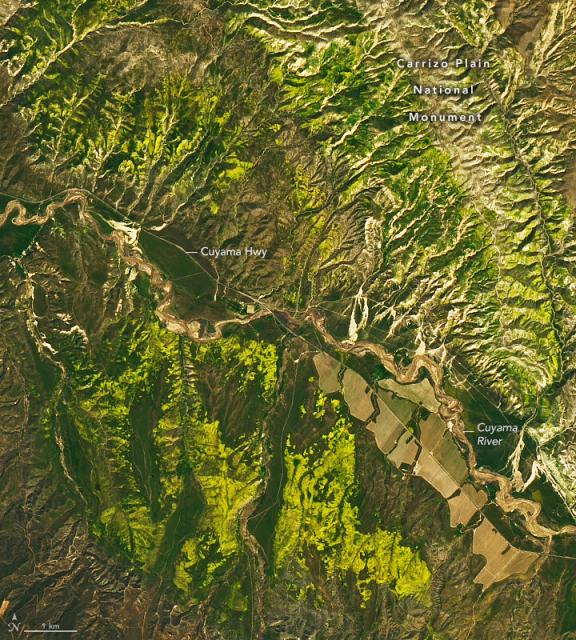
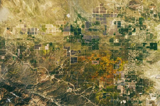
Intense winter rains in Southern California blossomed into a magnificent display of wildflowers. #Landsat saw it best in this image of Carrizo Plain National Monument captured on April 6, 2023. ⤵️
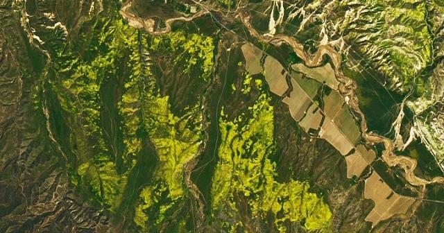
A Flood of Wildflowers
Winter 2023 brought unusually intense rains to Southern California, which was followed by a magnificent bloom of wildflowers in spring.go.nasa.gov
As coastal waters heat up, rains and floods are swamping Peru.
These #Landsat images show before (left) and after (right) flood waters from two nearby rivers filled Lago La Niña. 🌧️ go.nasa.gov/40XmxAN
#NASAEarth
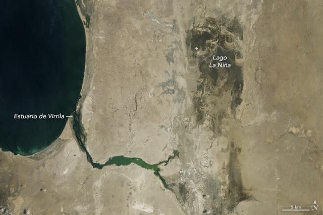
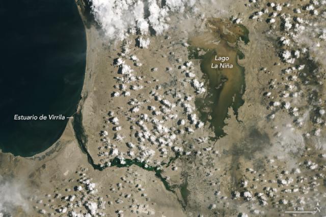
Warming Water and Downpours in Peru
As coastal waters heat up, torrential rains and floods are swamping the northern part of the country.go.nasa.gov
Is this Earth or mars? 🤔
@nasa scientists discovered dozens of new microbe species while studying lava caves in Hawaii to better understand how to search for past or present life on Mars. go.nasa.gov/3mk5hqj
#NASAEarth
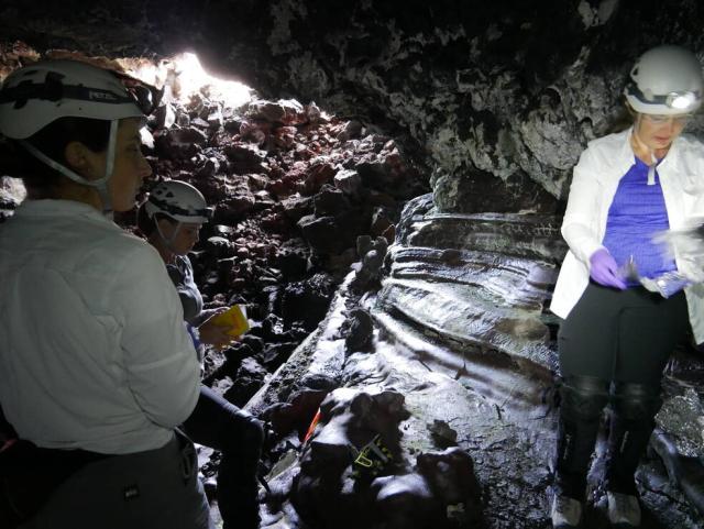
How Exploring Hawaiian Caves Helps NASA Search for Life on Mars
When a scientist found herself inside a cave beneath the Mauna Loa volcano, she felt like she had entered another world. She may as well have been on Mars, and that's precisely why she had come.Svetlana Shekhtman (NASA)
A massive seaweed bloom in the Atlantic is the largest on record for March.
This map shows the seaweed stretching from the west coast of Africa to the Gulf of Mexico. Scientists estimate the seaweed totaled about 13 million tons. go.nasa.gov/3KnVyar
#NASAEarth
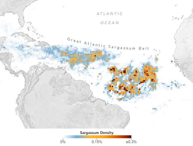
A Massive Seaweed Bloom in the Atlantic
A belt of seaweed that stretches from the west coast of Africa to the Gulf of Mexico is the largest on record for March.go.nasa.gov
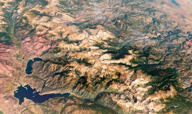
Tectonic uplift millions of years ago formed Edwards Plateau in Texas, shown in this @Space_Station astronaut photo.
Darker soils of the Blackland Prairies can be seen between the urban areas of Austin and San Antonio. go.nasa.gov/3zYsim9
#NASAEarth
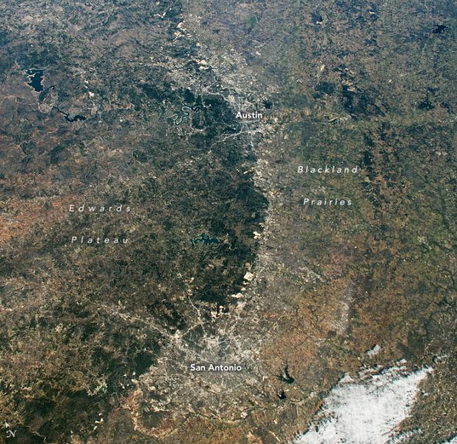
A Plateau in the Heart of Texas
Tectonic uplift millions of years ago formed Edwards Plateau, a feature that influences how people now use the land.go.nasa.gov
Scientists with NASA’s EXPORTS mission set out to study carbon in the ocean with ships, buoys, gliders and more.
Now, @NASAEarthdata scientists are working to manage all of that data, which will ultimately help develop models of ocean carbon. go.nasa.gov/3GpI50K
#NASAEarth
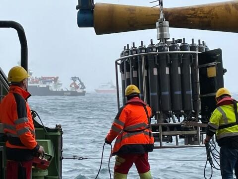
Deep Data: Analyzing Carbon in the Ocean
NASA experts created a data ecosystem for an ambitious field campaign studying the carbon cycle in the ocean.Charlie Plain (Earthdata)
A @nasa study confirms: major wet and dry events are occurring more often due to climate change.
There were four of these events, on average, per year from 2015-2021. That’s up from an average of three per year for 2002-2015. go.nasa.gov/3MbImbm
#NASAEarth
Warming Makes Droughts, Wet Events More Frequent, Intense
Scientists have predicted that droughts, floods will become more frequent and severe as our planet warms and climate changes, but measuring this on regional scales has proven difficult.Jennifer Fadoul (NASA)
The scientists analyzed 20 years of GRACE and GRACE-FO data in the study.
These satellites use Earth’s gravity to measure changes in water stored in soils, lakes, aquifers, snow and more.
More on the mission: go.nasa.gov/3MgRefR
#NASAEarth
