
#NASA
Launch of the International SWOT (Surface Water and Ocean Topography) Mission (NASA Broadcast)
Watch with NASA as we launch an international mission to understand the Earth's water like never before.SWOT, the Surface Water and Ocean Topography mission,...YouTube
Making moves!
Ingenuity #MarsHelicopter recently completed Flight 36, staying above the Martian surface for just over a minute (60.52 seconds)!
See more stats in the flight log: go.nasa.gov/2U43zuH
#NASAJPL
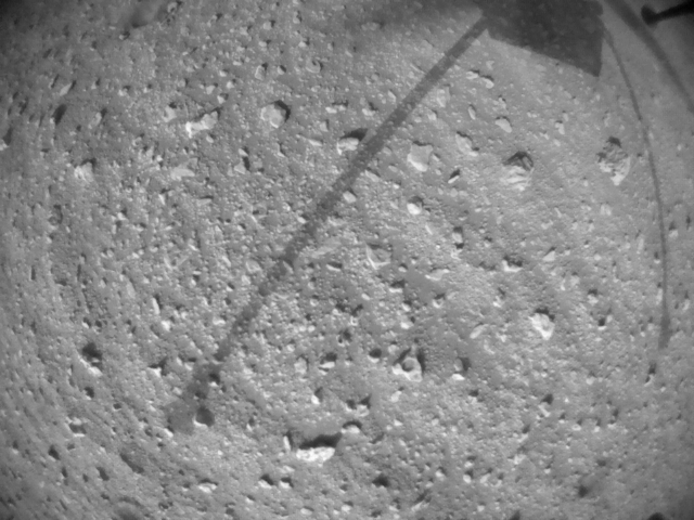
Mars Helicopter - NASA
The Mars Helicopter is a technology demonstration to test powered flight on another planet for the first time.go.nasa.gov
Explorers in #Chicago have been checking out twins of me and the #MarsHelicopter at @AdlerPlanet. Models will be there through Jan. 3, and tonight @nasa experts are on hand to answer your questions during the Adler at Night event!
#MarsRoverTour info: go.nasa.gov/marsrovertour
#PerseveranceRover

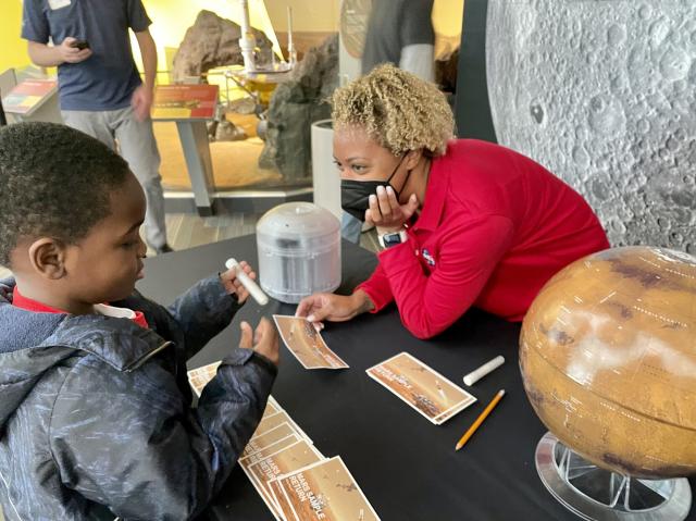
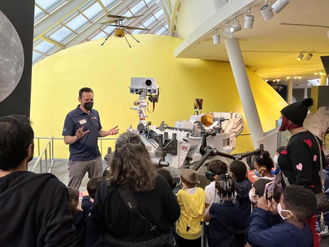
Roving With Perseverance - NASA
Mars Perseverance model and related exhibits go on the road to museums around the country.go.nasa.gov
Join experts from @nasa, @CNES, @SpaceX, and the U.S. Space Force to discuss the prelaunch status of the Surface Water and Ocean Topography (SWOT) satellite. Share your questions using #AskNASA. twitter.com/i/broadcasts/1lDGL…
#NASAJPL
#NASA
#NASAExoplanets
Wide-field Infrared Survey Explorer (WISE)
NASA.gov brings you the latest images, videos and news from America's space agency. Get the latest updates on NASA missions, watch NASA TV live, and learn about our quest to reveal the unknown and benefit all humankind.NASA
#NASAMars
NASA's Perseverance Records a Martian Dust Devil – NASA Mars Exploration
This video and audio show the results of NASA’s Perseverance Mars rover using its SuperCam microphone to record the sounds of a Martian dust devil – the first time any such recording has been made.NASA Mars Exploration
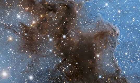
Take a closer look inside the Carina Nebula 👀
Join scientist Dr. Ken Carpenter on a journey through one of the most dynamic regions in the night sky!
For more information: go.nasa.gov/3PsYTHx
#Hubble
Caldwell 92
Astronomers targeted Caldwell 92 to create one of the largest panoramic images ever taken with Hubble’s cameras, generating a stunning 50-light-year-wide view of the tumultuous central region of this strange stellar nursery.Edward Henderson (NASA)
And if you can't get enough Carina, be sure to check out our recently released image featuring a small section of this stunning nebula!
Hubble’s Sparkling New View of the Carina Nebula
This sparkling new image depicts a small section of the Carina Nebula, one of the NASA Hubble Space Telescope’s most-imaged objects.Andrea Gianopoulos (NASA)
All eyes on lo, the most volcanic place in the solar system!
NASA’s Juno mission will get images of the Jovian moon Io this week as it explores Jupiter’s inner moons. Juno is performing double duty observing Jupiter's moons with even more flybys to come! go.nasa.gov/3WezzXU
#NASAJPL
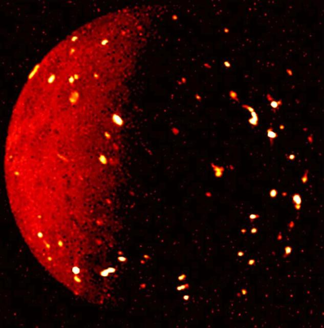
NASA’s Juno Exploring Jovian Moons During Extended Mission
After revealing a trove of details about the moons Ganymede and Europa, the mission to Jupiter is setting its sights on sister moon Io.NASA Jet Propulsion Laboratory (JPL)
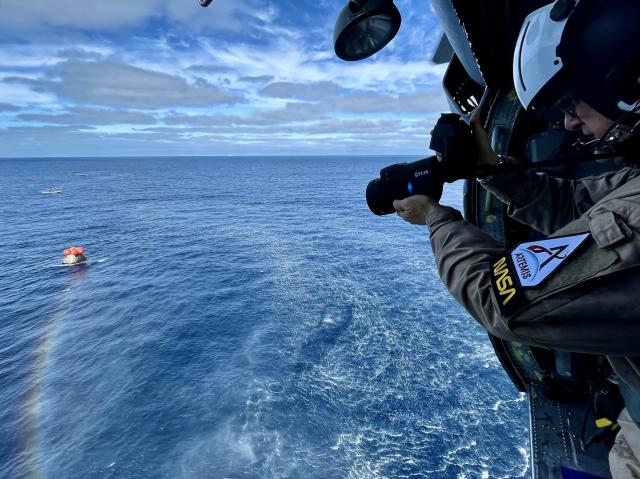
Honey, I’m home.
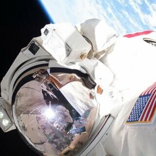
In this image, a member of the recovery team captures imagery of @NASA_Orion shortly after it splashed down in the Pacific Ocean off the coast of Baja California on Dec. 11. The splashdown marked the successful conclusion of the #Artemis I mission.
#NASAArtemis #Artemis
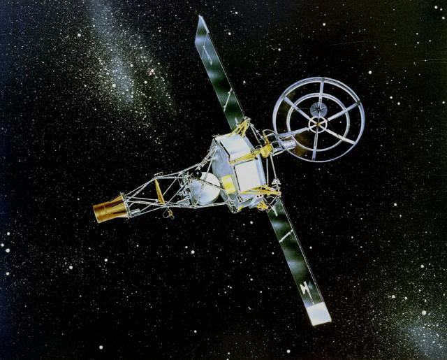
Six decades of exploring the planets! On Dec. 14, 1962, NASA's Mariner 2 spacecraft made the first successful flyby of another world when it buzzed by Venus. 🛰⚪
Follow our current expeditions, operating at points ranging from the Sun to beyond Pluto: solarsystem.nasa.gov
#NASASolarSystem
Home – NASA Solar System Exploration
NASA’s real-time science encyclopedia of deep space exploration. Our scientists and far-ranging robots explore the wild frontiers of our solar system.NASA Solar System Exploration
#NASA
Earth's Moon
The fifth-largest moon in the solar system, Earth's Moon is the only place beyond Earth where humans have set foot.NASA Solar System Exploration
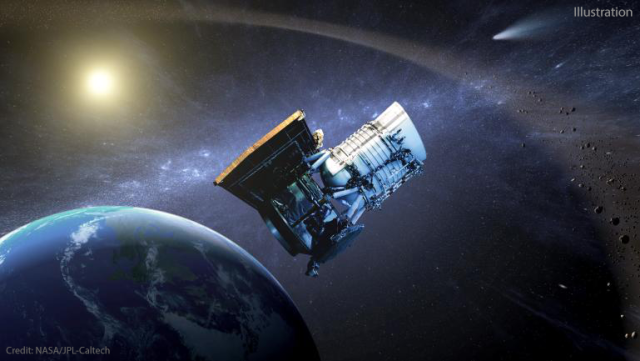
#OTD in 2009 our Wide-field Infrared Survey Explorer (WISE) launched!
WISE's all-sky survey led to mind-expanding science including:
⚫ Uncovering millions of black holes
⭐ Discovering the coolest class of stars
💡 Imaging the most luminous galaxy
More: go.nasa.gov/3URn6Za
#NASAUniverse
#NASAhqphoto
In 2020 and 2021, global atmospheric concentrations of methane – a potent greenhouse gas – surged in record growth since measurements began ~40 years ago.
This video shows global methane emissions from wetlands since 1980. Wetlands are one of the largest single methane sources.
#NASAEarth
Wetlands store massive quantities of carbon in soils. But as the climate gets warmer or wetter, microbes in the wetlands start releasing more methane into the atmosphere.
On Dec. 14 at 2pm ET, @nasa scientists are discussing their findings at #AGU22. go.nasa.gov/3UYuIcp
#NASAEarth
NASA Press Events at 2022 Fall AGU Meeting
NASA researchers will be presenting findings on Earth and space sciences Dec.12-16 at the American Geophysical Union's 2022 Fall meeting, being held virtually and in Chicago this year.Karen Fox (NASA)
This fall, @nasagoddard scientists trekked through and flew over Florida marshes as part of the Blueflux project.
The team is studying the exchange of carbon and methane through mangrove ecosystems with research aircraft and scientists on the ground. 🛫 🛶go.nasa.gov/3Wjds2I
#NASAEarth


For the first time, @nasa scientists mapped global salt marsh losses and their carbon impact.
The world has lost 561 square miles (1,453 square kilometers) of marshes over the past 20 years, the team found. go.nasa.gov/3FvLcCT
#NASAEarth
NASA Scientists Map Global Salt Marsh Losses and Their Carbon Impact
Earth has lost 561 square miles of salt marshes over the past 20 years, according to a new NASA-led study of the first consistent global accounting of salt marsh locations and changes.Kate Ramsayer (NASA)
In a new study, scientists used #Landsat imagery from @nasa/@usgs to track shoreline changes and dramatic wetlands losses in Louisiana from 1984 to 2020.
The state lost nearly 21 square miles of important and vulnerable wetland ecosystems every year. go.nasa.gov/3UVZHFN
#NASAEarth
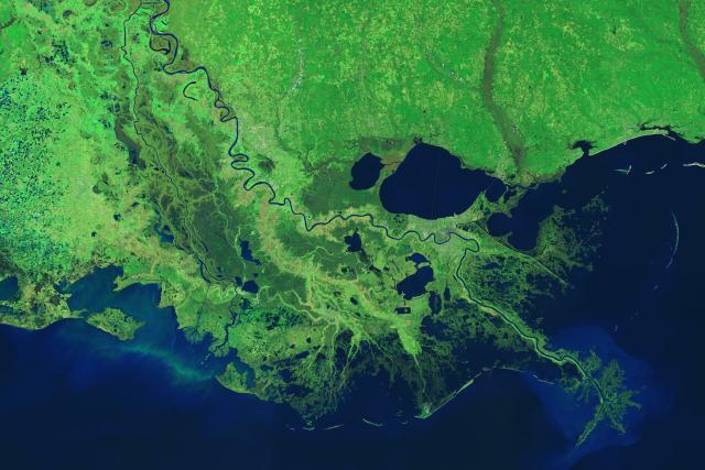
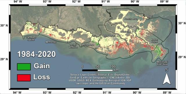
Satellites Help Scientists Track Dramatic Wetlands Loss in Louisiana
New research uses NASA satellite observations and advanced computing to chronicle wetlands lost (and found) around the globe.Kate Ramsayer (NASA)
The WISE/NEOWISE telescope started mapping our sky after its launch #OTD in 2009. A video of its view reveals dying stars, hungry black holes and more. go.nasa.gov/3FeMsdG
#NASAExoplanets
NASA Telescope Takes 12-Year Time-Lapse Movie of Entire Sky
Pictures of the sky can show us cosmic wonders; movies can bring them to life. Movies from NASA’s NEOWISE space telescope are revealing motion and change across the sky.NASA Jet Propulsion Laboratory (JPL)
#NASAhistory

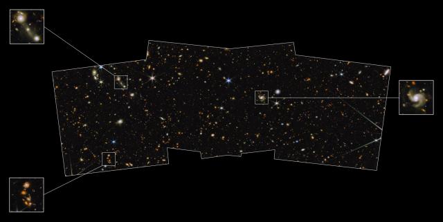
Galactic panoramic 📸
This shot is just a portion of what will be the complete wide field covered by this Webb program, but it’s already unveiling galaxies in unprecedented detail and depth. The multi-wavelength image combines Webb & @NASAHubble data: go.nasa.gov/3W37S4D
#JamesWebb
A new view of an old favorite!
This sparkling new image depicts a small section of the Carina Nebula, one of Hubble’s most-imaged objects. It’s about 7,500 light-years away, and busy with cosmic activity – including star birth and death!
Read more: go.nasa.gov/3PsWuwv
#Hubble
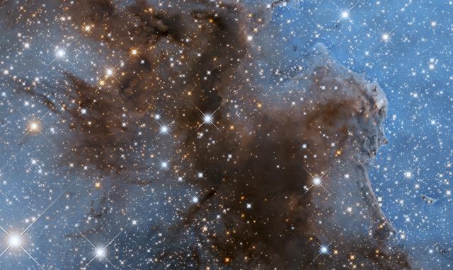
Hubble’s Sparkling New View of the Carina Nebula
This sparkling new image depicts a small section of the Carina Nebula, one of the NASA Hubble Space Telescope’s most-imaged objects.Andrea Gianopoulos (NASA)
The Carina Nebula is included in the Caldwell Catalog, published in December 1995 – 27 years ago this month!
Stargazer Sir Patrick Moore gathered a list of cosmic targets to encourage fellow amateur astronomers to experience the night sky's wonders.
Explore - The Night Sky | Hubble’s Caldwell Catalog
NASA.gov brings you the latest images, videos and news from America's space agency. Get the latest updates on NASA missions, watch NASA TV live, and learn about our quest to reveal the unknown and benefit all humankind.NASA
#NASAhistory
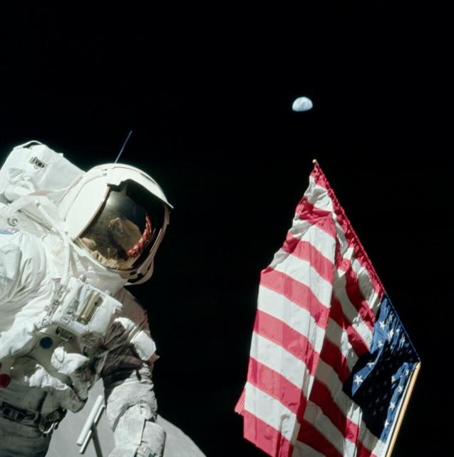
Lunar Dust and Duct Tape
Image Credit: Apollo 17, NASA
apod.nasa.gov/apod/ap221214.ht… #APOD

APOD: 2022 December 14 - Lunar Dust and Duct Tape
A different astronomy and space science related image is featured each day, along with a brief explanation.apod.nasa.gov
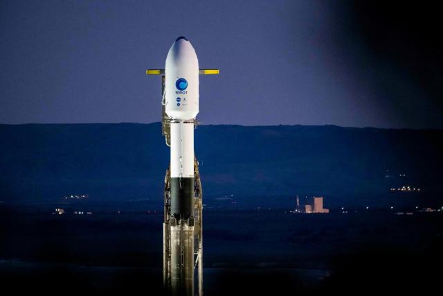
Team Earth! 🌎
Water connects us all – and that couldn't be more true than with the international SWOT mission, which was jointly developed by @nasa and @CNES with contributions from @csa_asc and @spacegovuk.
Follow along! SWOT is set to launch on Dec. 15. #TrackingWorldWater
#NASAJPL
#NASA
NASA’s Big 2022: Historic Moon Mission, Webb Telescope Images, More
2022 is one for the history books as NASA caps off another astronomical year.Gerelle Dodson (NASA)
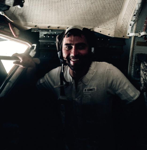
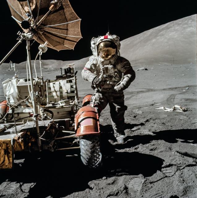
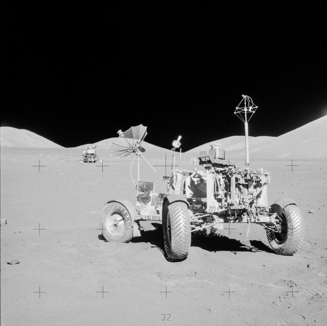
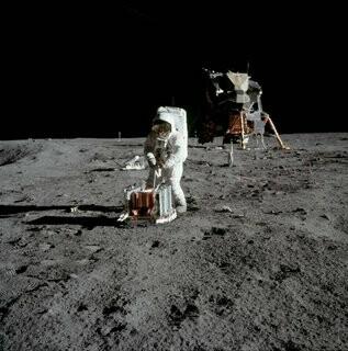
Farewell to the LRV 👋
Near the end of their last EVA, #Apollo17 astronauts Cernan and Schmitt parked the rover with its camera pointed at the LM to record its launch from the Moon. Over 3 days, they had completed 22 hours of EVAs—the most of all the Apollo missions. #Apollo50th
#NASAhistory
#NASAhistory
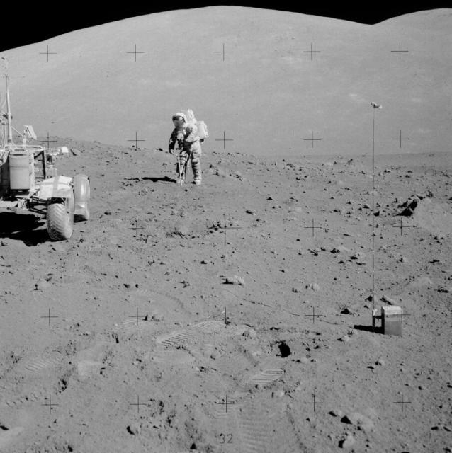
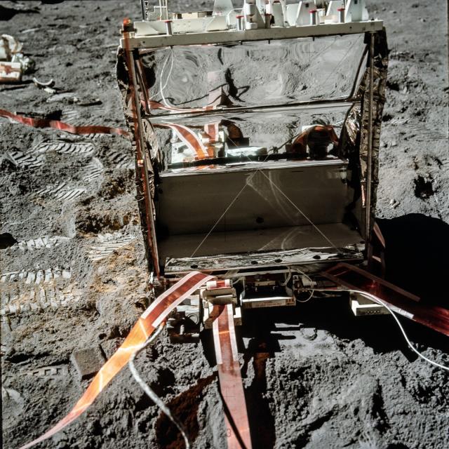
Seismometers were deployed during each of the Apollo missions that reached the lunar surface and for decades have been used to investigate the internal structure of the Moon.
📷 The lunar mass spectrometer, one of the instruments of the ALSEP, is seen in the foreground.
#NASAhistory
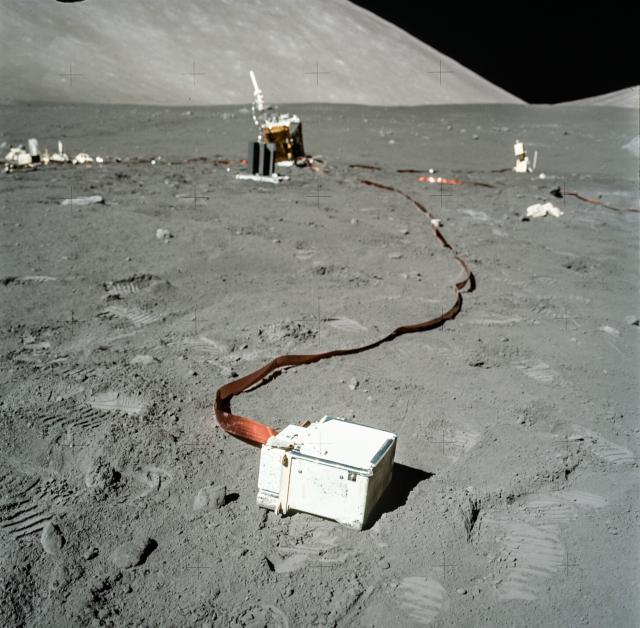

One of the types of moonquakes detected, originating at moderately shallow depths of 20-30 km, can register up to a startling 5.5 on the Richter scale and can last for over 10 minutes!
More about moonquakes: go.nasa.gov/3Y0VNOQ
#NASAhistory
Ep. 266: Moonquakes
Lunar Seismologist Dr. Ceri Nunn joins us from NASA’s Jet Propulsion Laboratory in California to talk about moonquakes and why studying seismic activity on the Moon is important for the future of human spaceflight. HWHAP Episode 266.Heidi Lavelle (NASA)
#NASAhistory
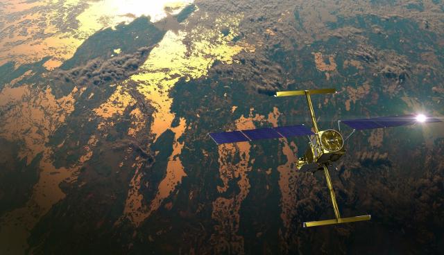
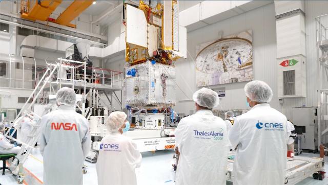
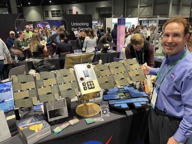
The heart of SWOT!
A new Earth-observing satellite will survey water on more than 90% of Earth’s surface and see our planet's water in higher definition than ever before. An instrument called the Ka-band Radar Interferometer (KaRIn) is making it possible: go.nasa.gov/3FgGMzQ
#NASAJPL

Latest International Water Satellite Packs an Engineering Punch
Meet the scientific heart of the Surface Water and Ocean Topography mission, which will see Earth’s water in higher definition than ever before.NASA Jet Propulsion Laboratory (JPL)
KaRIn has been designed to capture very precise measurements of the height of water in Earth’s freshwater bodies and the ocean. And unlike other satellites, it can take measurements regardless of cloud cover or time of day.
SWOT is set to launch on Dec. 15. #TrackingWorldWater
#NASAJPL
At #AGU22? Don't miss #NASA activities by following @NASAExhibit!
If you're not at @theAGU event, you can still tune in to our hyperwall story at 3:25pm CT on how to use NASA's Eyes to follow the #CAPSTONE spacecraft & others around the Moon and in space: youtu.be/C9qSz70tI14
#NASATechnology
NASA Science Hyperwall Stories at the American Geophysical Union Fall Meeting 2022 – Tuesday, 12/13
Join NASA experts at the 2022 American Geophysical Union Fall Meeting in Chicago, IL. You will hear about How to use NASA’s Eyes App, Open Science and the up...YouTube
#NASAhqphoto
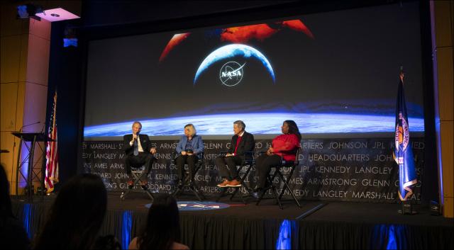
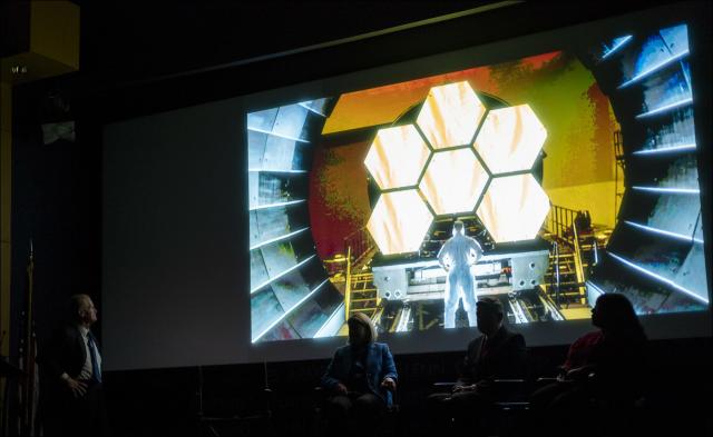
20221213 Agency End-of-Year All Hands
Explore this photo album by NASA HQ PHOTO on Flickr!NASA HQ PHOTO (Flickr)
ScienceFictionBooks
in reply to NASA • • •