Search
Items tagged with: nasaearth

Scientists are using satellite images to locate landslides following the devastating earthquakes in parts of Türkiye and Syria on February 6, 2023.
This #Landsat 9 image shows small landslides along a valley east of Sarıseki, Türkiye, on Feb. 14. go.nasa.gov/3IROLGI
#NASAEarth
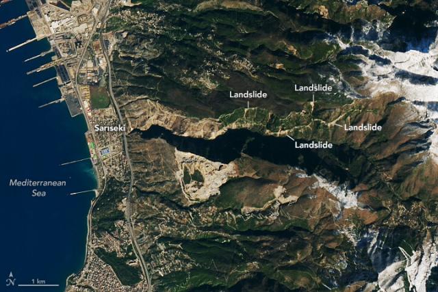
Landslides in Türkiye
Scientists are using satellite images to locate landslides following the powerful earthquakes that struck in early February.go.nasa.gov

NASA’s Earth Applied Sciences Disasters program area is tracking developments related to the earthquakes and their aftermath and sharing resources to aid ongoing response efforts and risk assessments.
Check here for the latest: go.nasa.gov/3m5umVH
#NASAEarth
Check out this dynamic duo:
COWVR and TEMPEST are small and mighty weather instruments, now helping forecasters track tropical cyclones. They were built to test the potential of using low-cost sensors to do some of the work of bulkier, pricier satellites. go.nasa.gov/3ZiYlI4
#NASAEarth
Dynamic NASA-Built Weather Sensors Enlisted to Track Tropical Cyclones
Known as COWVR and TEMPEST, the duo is demonstrating that smaller, less expensive science instruments can play an important role in weather forecasting.Tony Greicius (NASA)
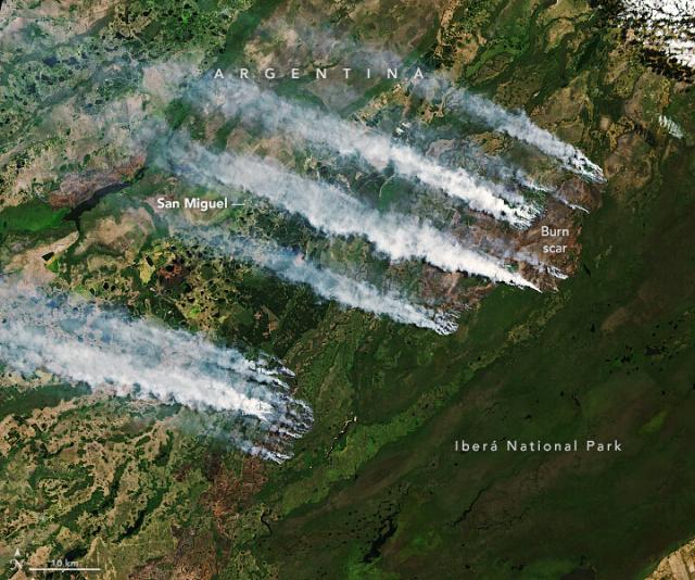
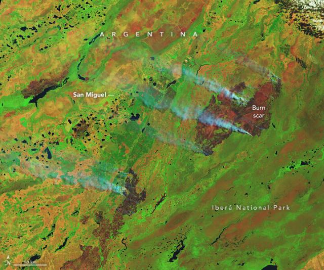
Fueled by a heatwave and prolonged drought, fires continue to burn in the Iberá National Park in northeastern Argentina.
The fires began in late December 2022 and were still ablaze when #Landsat 9 took these images on Feb. 19, 2023. go.nasa.gov/41efMuW
#NASAEarth
Fires Burn in Argentina’s Iberá National Park
Fueled by a heatwave and prolonged drought, fires burned the protected Argentine oasis, home to capybaras and jaguars.go.nasa.gov
Tropical Cyclone Freddy made landfall on the east coast of Madagascar on Feb. 21, 2023 after traveling across the Indian Ocean for two weeks.
This @noaa-20 photo was taken just prior to landfall.
🌀: go.nasa.gov/3lXjAAP
#NASAEarth
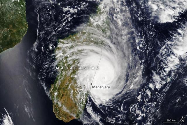
Cyclone Freddy Hits Madagascar
The tropical cyclone made landfall on February 21, 2023, after traveling for more than two weeks across the Indian Ocean.go.nasa.gov
An outbreak of devastating fires in Chile in early February 2023 has diminished, but the burned landscape remains visible from space.
NASA’s Terra satellite took these false-color images before (left) and after the fires (right).
Learn more: go.nasa.gov/3IhChql
#NASAEarth
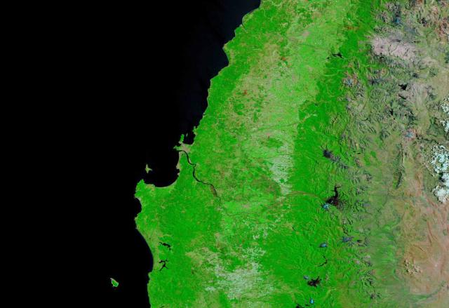
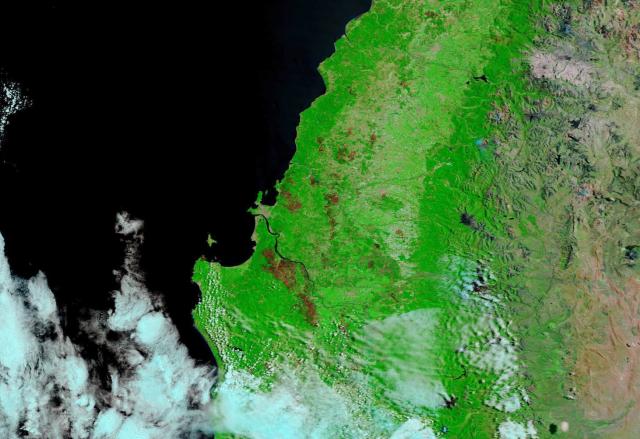
Fires Scar the Chilean Landscape
The outbreak of fires in early February 2023 has diminished, but the burned area remained visible from space.go.nasa.gov
Most asteroids are small enough that they burn up in Earth’s atmosphere. But what would happen if a large asteroid were heading toward us?
This week on @nasa’s Curious Universe podcast, scientists talk about defending Earth from asteroids. 🎧: go.nasa.gov/3xG61Z9
#NASAEarth

Curious Universe Season 5 Ep 1: “Defending the Planet from Asteroids”
Our solar system contains millions of asteroids, orbiting our sun and rocketing through the night sky! Join scientists Kelly Fast, Tom Statler, and Davide Farnocchia as we discover what we can learn from these building blocks of the universe, and ho…Gary Daines (NASA)
Inspiration is all around us.
Hamid Oloso, a computational scientist at @NASAGoddard, was inspired by different people along his journey from growing up in Ibadan, Nigeria to working at NASA on Earth system models.
Learn more about his story: go.nasa.gov/41ixpJY
#BHM
#NASAEarth

Happy Mardi Gras! 💜💛💚
During Mardi Gras season in 2012, the Mississippi River broke through its eastern bank and created a new channel to the Gulf of Mexico, the Mardi Gras Pass. #Landsat 8 recently captured this image of the pass.
Learn more: go.nasa.gov/41km8t0
#NASAEarth
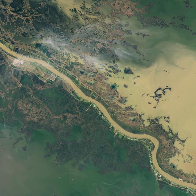
Mardi Gras Pass
This free-flowing distributary reconnects the mighty Mississippi to the wetlands of Louisiana.go.nasa.gov
An astronaut on the @Space_Station captured this photo of South Padre Island along the Texas coast.
Barrier islands like this one play a critical role in protecting the mainland from the damaging effects of storms. go.nasa.gov/3SaSFO1
#NASAEarth
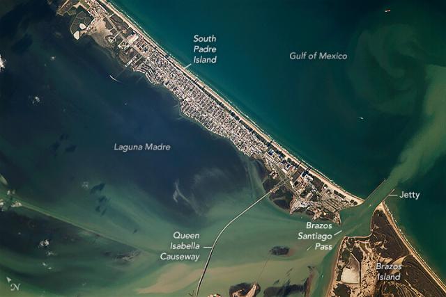
South Padre Island
The barrier islands along the coast of Texas help sustain lagoon ecosystems and protect the mainland from damaging storms.go.nasa.gov
Understanding ocean color from satellite images can be challenging.
The @nasaocean PACE mission, launching in 2024, will see Earth’s ocean colors in new detail.
Learn about PACE: go.nasa.gov/3IuYkv1 🌊 🌈 🛰️
#NASAEarth
Ice extent jumped to 21 percent in early February in response to a cold snap. But since then, it has declined. Maximum ice cover is usually between mid-February and early March.
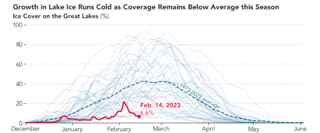
Great Lakes Low on Ice
This winter, ice cover in the basin has hovered at unusually low levels.go.nasa.gov
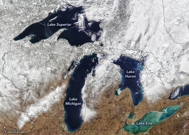
The Great Lakes have been unusually ice-free this winter. In this image from Feb. 13, ice cover on the lake was 7 percent – the lowest ice cover measured on this date of any year since 1973 when satellite-based record keeping began.
📸 Image by VIIRS on the @NOAA-20 satellite
#NASAEarth
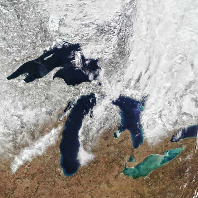
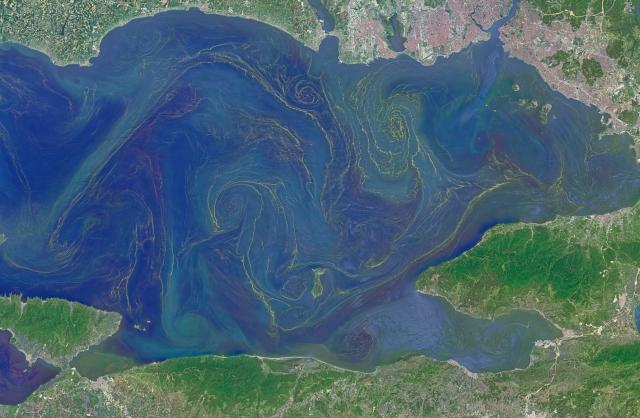
Why does Lake Erie look so different from the other lakes?
Sediment kicked up by storms gives its water a marbled-like look.
#NASAEarth

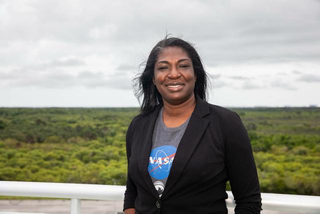
She pulls from her love of science and education to share NASA research, support large-scale public events across the country, and work closely with citizen scientists.
Get to know Dr. Trena Ferrell in this Q&A: go.nasa.gov/3KpnlsC
#NASAEarth

Trena Ferrell Inspires Through Science and Education
Trena Ferrell connects audiences with science and education at Maryland’s friendly neighborhood space flight center.Jessica Evans (NASA)
#NASAEarth
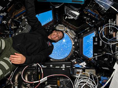
Space Station Images
NASA.gov brings you the latest images, videos and news from America's space agency. Get the latest updates on NASA missions, watch NASA TV live, and learn about our quest to reveal the unknown and benefit all humankind.NASA
Humans have taken over 4 million photographs from space! 🤯 #FunFact
Images taken by the @Space_Station crew can be used to study changes on Earth's surface over time or significant weather events.
More images from the ISS: go.nasa.gov/3IzpmS4 🧑🚀 📷 🌏
#NASAEarth
Space Station Images
NASA.gov brings you the latest images, videos and news from America's space agency. Get the latest updates on NASA missions, watch NASA TV live, and learn about our quest to reveal the unknown and benefit all humankind.NASA
Scientists at the University of Utah studied how snow worsens temperature inversions and air quality.
They found that the chance that air pollution would exceed national standards increased from about 5% to 22% when there was snow on the ground.
#NASAEarth
The air in Salt Lake City, Utah is often among the most polluted in the U.S.
Snow cover increases the chance of temperature inversions – when warm air acts like a lid, trapping pollutants near the surface, new research finds. go.nasa.gov/3xqvkOA
#NASAEarth
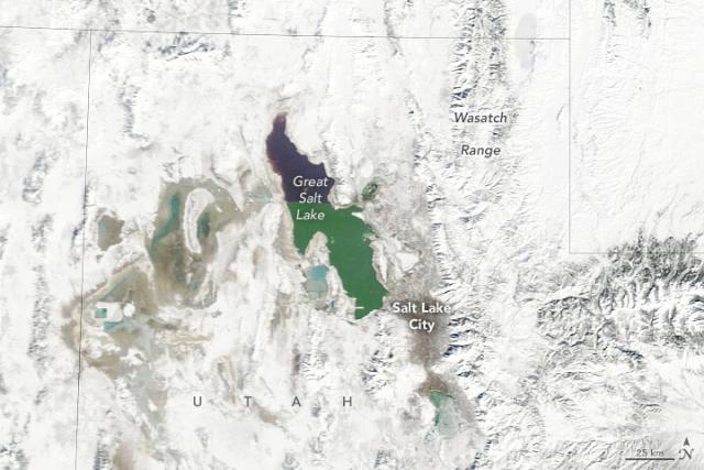
Snow and Haze in Utah
Snowy surfaces increase the chance of temperature inversions, which contribute to air quality problems in the Salt Lake City area.go.nasa.gov
The Salt Lake City area was covered in snow on Feb. 2, 2023, when @nasa’s Aqua satellite took this image.
At the time, @EPA data showed the air quality was above 100 on the air quality index, making it unhealthy for sensitive groups.
Full story: go.nasa.gov/3xqvkOA
#NASAEarth

Snow and Haze in Utah
Snowy surfaces increase the chance of temperature inversions, which contribute to air quality problems in the Salt Lake City area.go.nasa.gov
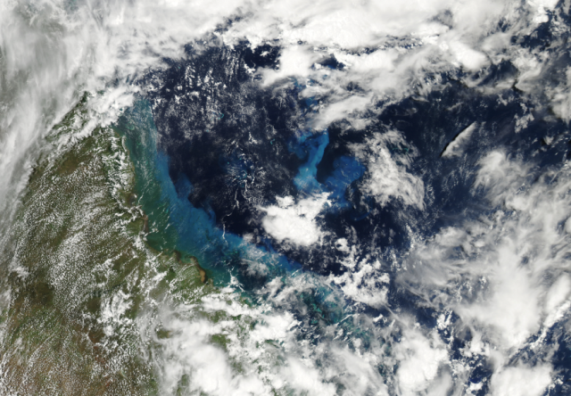
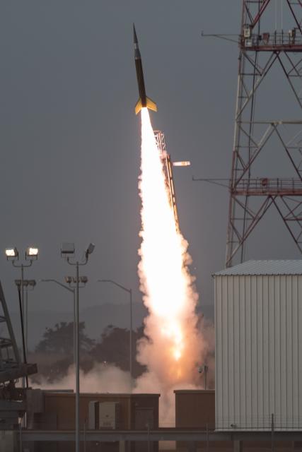
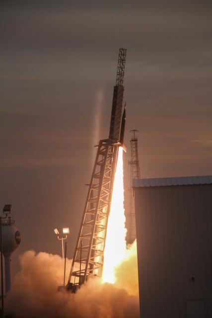
Today's rocket launches are part of an effort to study Earth's mesosphere, the layer of the atmosphere about 31 to 53 miles (50-85km) in altitude. 🚀☁️
The mesosphere is where meteors often burn up. It has its own chemistry and winds, and is where noctilucent clouds form!
#NASAEarth
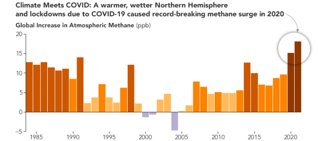
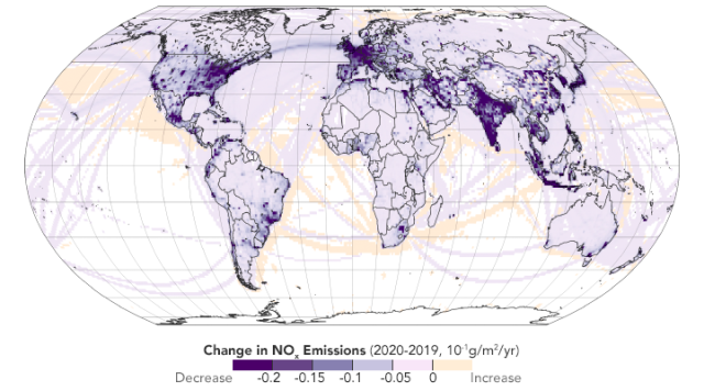
2020 saw a record-breaking rise in methane, a potent greenhouse gas. The increase was driven by a combination of warm, wet weather in the Northern Hemisphere and the COVID-19 lockdowns.
Why Methane Surged in 2020
Warm, wet weather in the Northern Hemisphere combined with COVID-19 lockdowns pushed the potent greenhouse gas to record levels.go.nasa.gov
A decrease of nitrogen oxides (NOx) pollution during the COVID-19 lockdowns indirectly slowed the removal of methane from the atmosphere.
NOx serves as an atmospheric “detergent” by reacting with methane and removing it from the atmosphere.
#NASAEarth
#NASAEarth
Cyclone Gabrielle lashed New Zealand in mid-February, adding to an unusually wet season and causing destructive flooding, storm surge, and landslides. 🌧️ 🌀
The @nasa @noaa Suomi NPP satellite took this image of the cyclone moving southeast on Feb. 14. go.nasa.gov/3k6LZDH
#NASAEarth
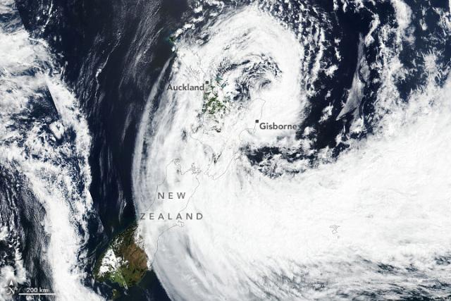
Cyclone Gabrielle Lashes New Zealand
The storm’s heavy rain in mid-February 2023 has added to an unusually wet start to the year.go.nasa.gov
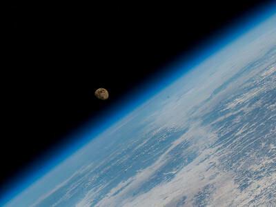
We’re feeling the love today while looking at this image of our Pale Blue Dot. 😍 Voyager 1 took this photo of Earth from about 3.7 billion miles (6 billion kilometers) away on #ValentinesDay in 1990.

Voyager 1's Pale Blue Dot | NASA Solar System Exploration
The Pale Blue Dot is a photograph of Earth taken Feb. 14, 1990, by NASA’s Voyager 1 when it was 3.7 billion miles (6 billion kilometers) from the Sun.NASA Solar System Exploration

It’s been a great 51 years with you, @NASA_Landsat! Thanks for helping us study our home planet. 🌏
Happy #ValentinesDay!
#NASAEarth
Hey, @NASAOcean!
Can you believe it’s already been about two months since SWOT launched? We can’t wait for it to help us get to know you better. 💙
#NASAEarth

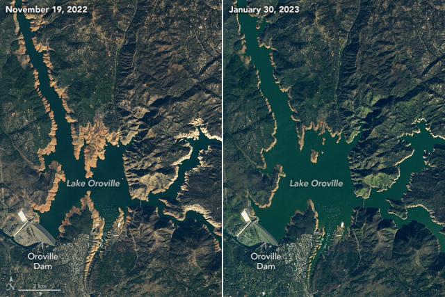
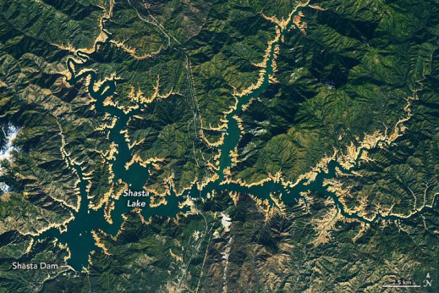
A series of storms brought lots of precipitation to California, helping replenish snowpack and reservoirs.
But was it enough to reverse a decades-long decline in groundwater? It’s unlikely, according to @nasagoddard research.
Full story: go.nasa.gov/3lo9nwK 🌧️ 💧
#NASAEarth

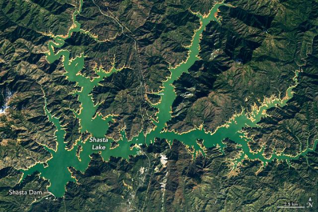
Reservoirs Rise, but Groundwater Woes Remain
The water delivered by winter storms in 2022-2023 is likely insufficient to reverse the longer-term depletion of California’s groundwater.go.nasa.gov

This chart shows an overall downward trend in terrestrial water storage (dark blue).
The other lines show why this is happening – groundwater (light blue) is sharply decreasing. Data are from @nasa’s GRACE and GRACE-FO satellites.
Full story: go.nasa.gov/3lo9nwK
#NASAEarth
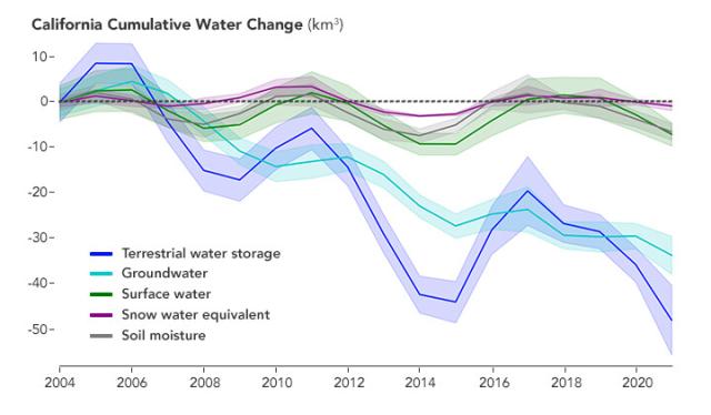
Reservoirs Rise, but Groundwater Woes Remain
The water delivered by winter storms in 2022-2023 is likely insufficient to reverse the longer-term depletion of California’s groundwater.go.nasa.gov
“Through my job communicating and doing outreach, I’m making people aware of how we all can contribute to a more sustainable environment, and helping future generations meet their needs.”
Celebrate #BHM: go.nasa.gov/3E09chG
#NASAEarth