Search
Items tagged with: nasaearth

#NASAEarth
Understanding Sea Level | NASA Sea Level Change
Get an in-depth look at the science behind sea level rise.NASA Sea Level Change Portal

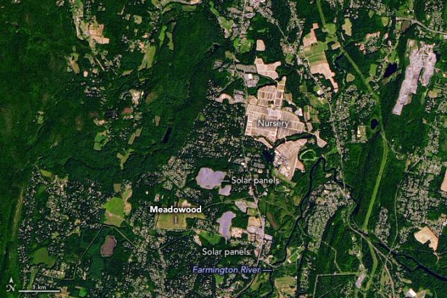
Experiences surrounding Dr. Martin Luther King Jr.’s time spent working on a tobacco farm likely influenced his future as a minister and civil rights activist.
This #Landsat 9 image shows the Meadowood tobacco farm, where King worked, in Simsbury, CT. go.nasa.gov/3X8BbmJ
#NASAEarth
The @Space_Station captured this view of Martin Luther King, Jr.’s birthplace, Atlanta, Georgia, in 2013.
@nasa honors Dr. King’s life and legacy by expanding mission equity, engaging in public service, and sharing knowledge for the benefit of humanity. go.nasa.gov/3IKKwNg
#NASAEarth
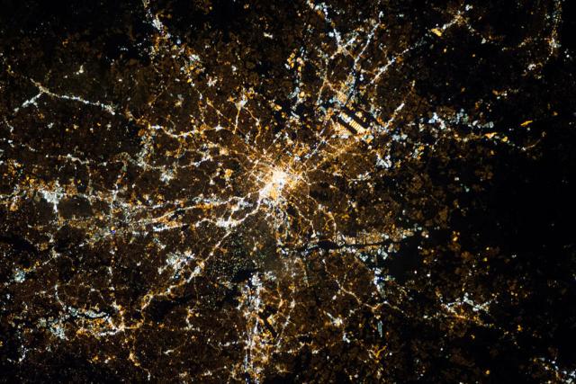
Atlanta Shines at Night
Martin Luther King, Jr.’s birthplace, Atlanta, Georgia, is seen on January 20, 2013, in this image from the International Space Station as it flew approximately 240 miles above the city.Monika Luabeya (NASA)
These swirls of discolored water are signs that Kaitoku, a triple-peaked submarine volcano north of Io Jima, is active. 🌊🌋
@nasa’s #Landsat 8 satellite captured these images on Jan. 3, 2023. Activity started in August 2022 has continued periodically. go.nasa.gov/3GFjh4i
#NASAEarth
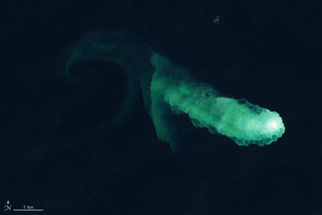
Kaitoku Says Hello
Swirls of discolored water are signs of activity from the underwater volcano.go.nasa.gov
#NASAEarth
Hunga Tonga-Hunga Ha‘apai Erupts
Several Earth-observing satellites collected data during and after the potent blast spurred a tsunami and lofted volcanic material high into the stratosphere.go.nasa.gov
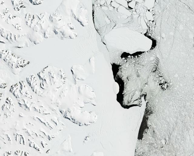
NASA’s Aqua satellite took this image of the Antarctic peninsula in Dec. 2022 when sea ice around the continent was breaking up and melting—a seasonal occurrence that usually begins in September and continues into February. 🧊
More: go.nasa.gov/3H0r7qn
#NASAEarth
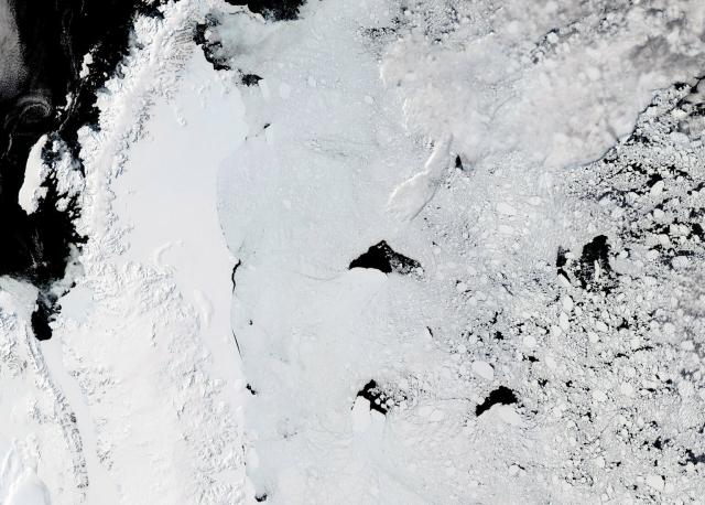
Clear Days for Iceberg Spotting
The summer sky was unusually cloud-free when NASA’s Aqua satellite passed over the Antarctic Peninsula.go.nasa.gov
But the decline so far in the 2022-2023 season has been especially steep.
According to the @NSIDC, the extent of sea ice around Antarctica at the end of December 2022 was the lowest in 45 years of satellite records.
#NASAEarth
A series of back-to-back atmospheric rivers has drenched much of California since late December 2022, with more on the way. 🌧️
These maps show surface soil moisture (higher in blue) from before the storms (left) and after, on Jan. 9 (right). go.nasa.gov/3CDzztd
#NASAEarth
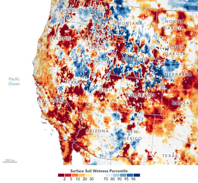
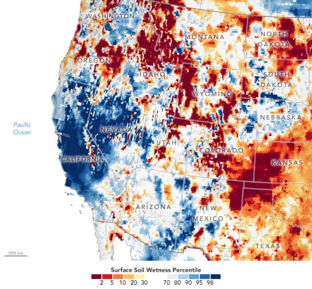
Storms Soak California
Unrelenting storms have inundated the state, delivering soil-saturating rain.go.nasa.gov
Why is Earth getting warmer?
The release of greenhouse gases, like carbon dioxide, from human activities is responsible for the majority of climate change. In our atmosphere, these greenhouse gases trap heat in the atmosphere, raising Earth’s temperature.
#NASAEarth
How do we know Earth’s climate is warming?
It’s not just us. Our partners at @noaa and other agencies and researchers around the world analyze the temperature records too. Their climate records show the same thing: Earth is warming significantly and rapidly.
#NASAEarth
Rainfall from Tropical Cyclone Ellie western Australia causing extensive flooding.
Floodwater is apparent in these false-color images from NASA’s Aqua satellite, taken on Dec. 17 (before the flooding) and Jan. 9 (after). go.nasa.gov/3ZpgvZm
#NASAEarth
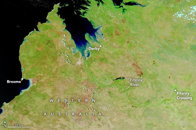
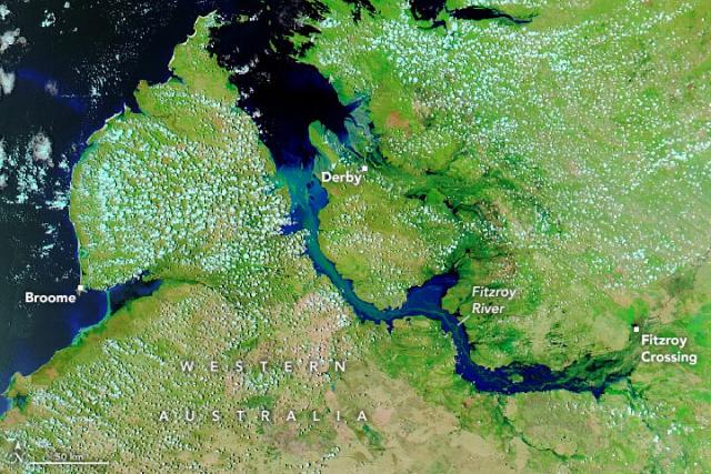
Flooding Along Australia’s Fitzroy River
Rainfall from an ex-tropical cyclone raised the river to record-high levels, flooding and isolating nearby communities.go.nasa.gov
NASA produces a record of Earth’s surface temperature from 1880 until the present day. 🌎 🌡️
On Thursday, we’ll announce where 2022 stands in our temperature record and share more about Earth and the ways it's warming. go.nasa.gov/3vWlVxz
#NASAEarth
NASA, NOAA to Announce 2022 Global Temperatures, Climate Conditions
Climate researchers from NASA and the National Oceanic and Atmospheric Administration (NOAA) will release their annual assessments of global temperatures and discuss the major climate trends of 2022 during a media briefing at 11 a.m.Roxana Bardan (NASA)
Greenland’s largest ice stream is expected to contribute more to sea level rise by the end of the century than models previously indicated.
This animation shows thinning since 2007 and projected through 2100, with the greatest thinning in yellow.
🧊➡💧: go.nasa.gov/3jV963G
#NASAEarth
Thinning of the Northeast Greenland Ice Stream
Greenland’s largest ice stream is expected to contribute more to sea level rise than models previously indicated.go.nasa.gov

NASA’s retired Earth Radiation Budget Satellite (ERBS) is expected to reenter Earth’s atmosphere after almost 40 years in space.
The @DeptofDefense currently predicts reentry at approximately 6:40 pm EST on Jan. 8.
go.nasa.gov/3Iv7Iz3
#NASAEarth
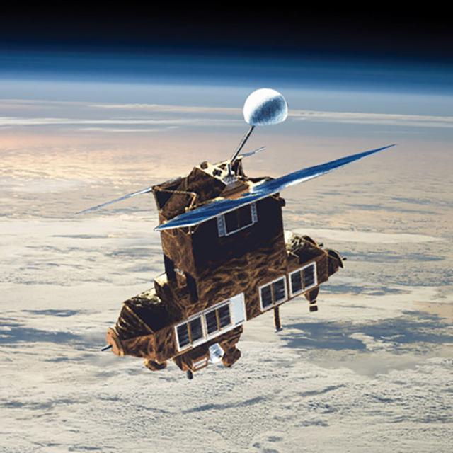
Retired NASA Earth Radiation Budget Satellite to Reenter Atmosphere
After almost four decades in space, NASA’s retired Earth Radiation Budget Satellite (ERBS) is expected to reenter Earth’s atmosphere in early January.Joe Atkinson (NASA)
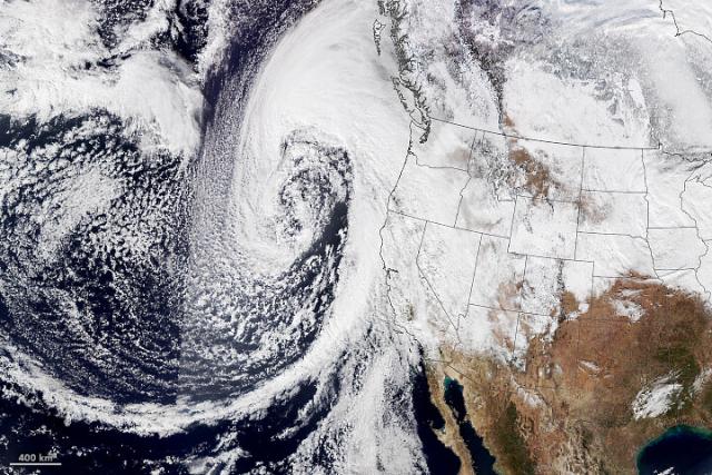
An atmospheric river drenched California on Jan. 4 and 5, 2023. 🌧️
A plume of moisture from the tropical Pacific interacted with a low-pressure system that rapidly strengthened over the northeast Pacific, producing an intense storm.
go.nasa.gov/3GK7wdR
#NASAEarth
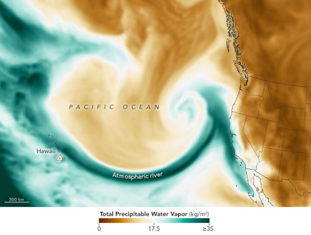
Atmospheric River Lashes California
The latest in a series of atmospheric rivers drenching the state was accompanied by hazardous winds and left thousands of people without power.go.nasa.gov
The map above shows how much potential liquid water is in the atmosphere on Jan. 4, 2023. The dark green swoop on the map indicates moisture flowing from the tropical Pacific toward California.
Data are from @nasagoddard's GEOS ADAS. go.nasa.gov/3GIAQ4u
#NASAEarth
This @NOAA-20 image from Jan. 4, 2023, at 1:20 p.m. PST and shows the storm intensifying.
When air pressure in a mid-latitude cyclone rapidly drops and winds intensify, these storms can undergo a process can become “bomb cyclones.” go.nasa.gov/3GK7wdR
#NASAEarth
Atmospheric River Lashes California
The latest in a series of atmospheric rivers drenching the state was accompanied by hazardous winds and left thousands of people without power.go.nasa.gov
#NASAEarth

Weather Whiplash
The configuration of the polar vortex may have played a role in unleashing bitter cold followed by record warmth in North America.go.nasa.gov
#NASAEarth
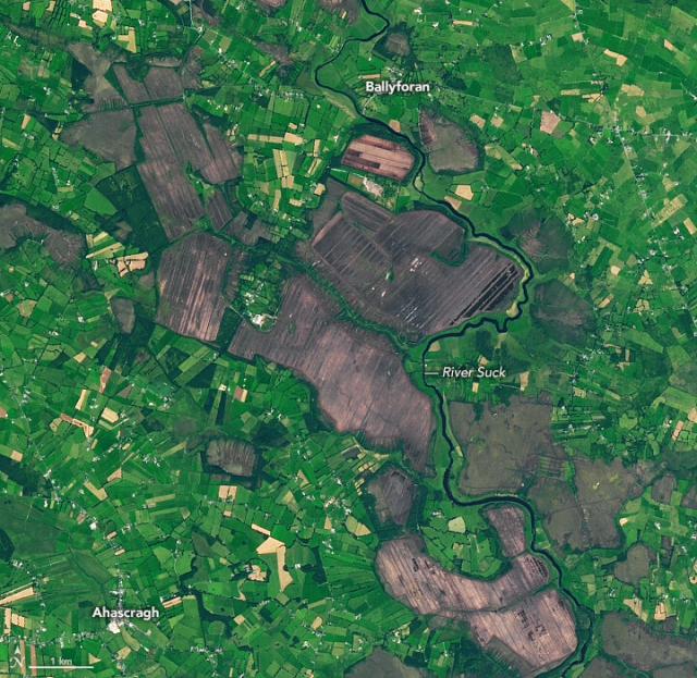
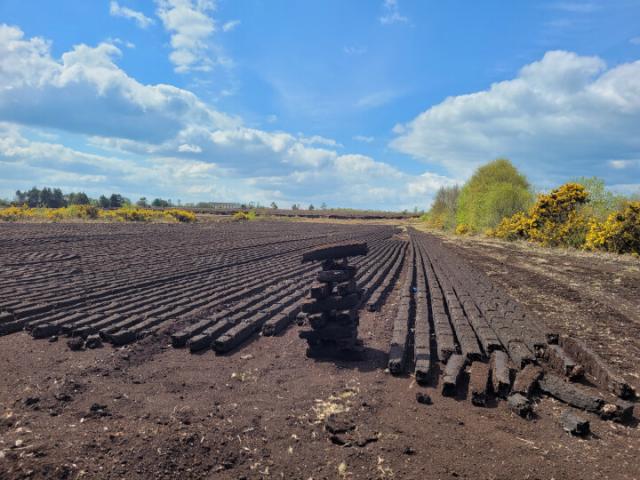
Ireland’s Cutaway Peatlands
Peatlands have been mined in Ireland for centuries, but concern for climate is changing how they are managed.go.nasa.gov
2022 ended with a shiver, but the start of 2023 broke a sweat. 🥶🥵
This weather whiplash may have been caused by changes in the polar vortex, the band of strong westerly winds over the Arctic. Details: go.nasa.gov/3XaD4iK
#NASAEarth
Weather Whiplash
The configuration of the polar vortex may have played a role in unleashing bitter cold followed by record warmth in North America.go.nasa.gov
Heavy rain on New Year’s Eve 2022 flooded California near San Francisco and Sacramento.
Flooding is visible in the false-color satellite image from Jan. 1, 2023 (right), with water in blue, compared to the image from Dec. 16, 2022 (left).
Details: go.nasa.gov/3GiX0Ja 🌧️
#NASAEarth
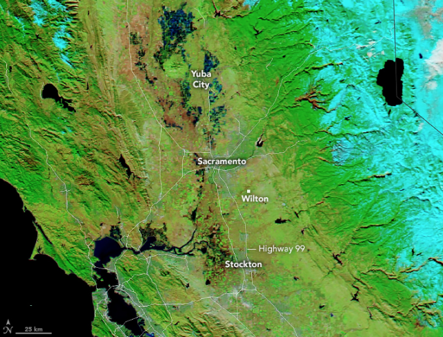
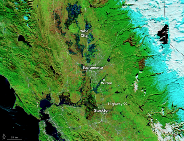
Floodwater Inundates North-Central California
Heavy rain and levee breaches triggered flooding in parts of Sacramento and the Bay Area.go.nasa.gov
Not snow on the beach, but these winter photos taken by astronauts aboard the @Space_Station are definitely weird and beautiful. 🎶 ❄️ #HappyNewYear
See the gallery: go.nasa.gov/3i3In4y
#NASAEarth
Collection - Winter from the International Space Station
Over the years, astronauts aboard the orbiting laboratory have snapped spectacular photographs of Earth’s snow and ice in both hemispheres.go.nasa.gov
#NASAEarth
#NASAEarth
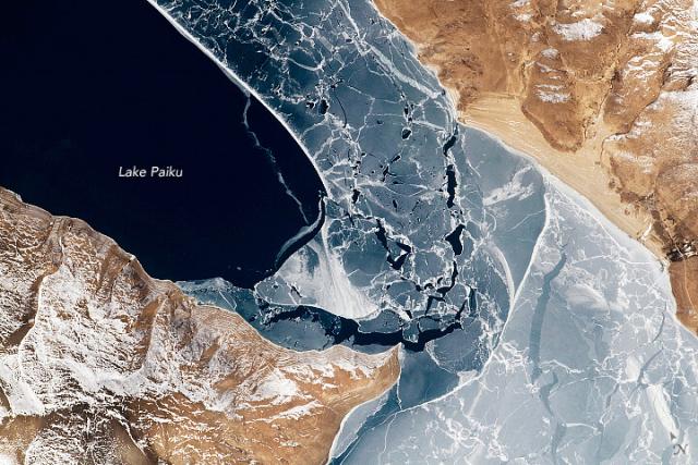
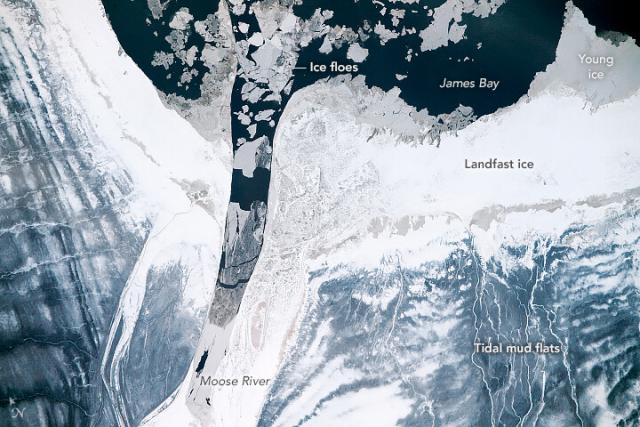
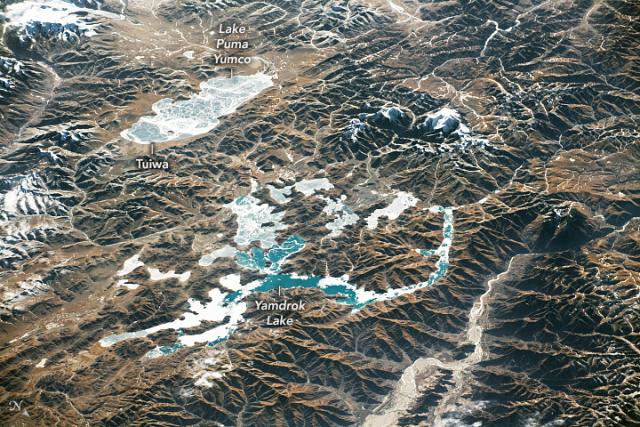
Icy Lake Paiku
This deep lake on the southern Qinghai-Tibet Plateau freezes over during winter, curbing the large changes in lake level observed during other seasons.go.nasa.gov
#NASAEarth
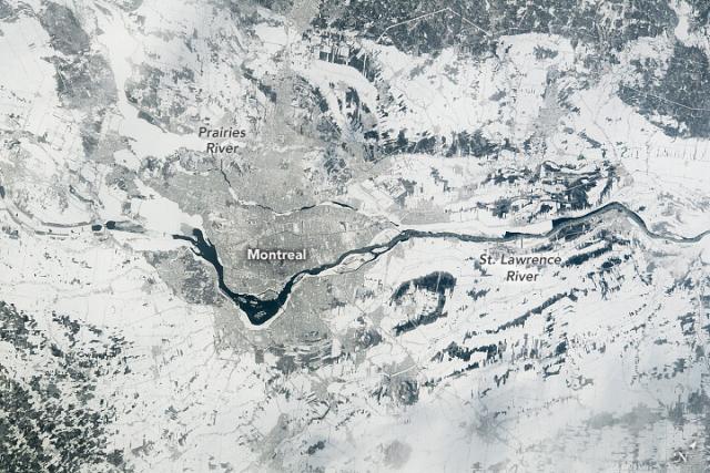
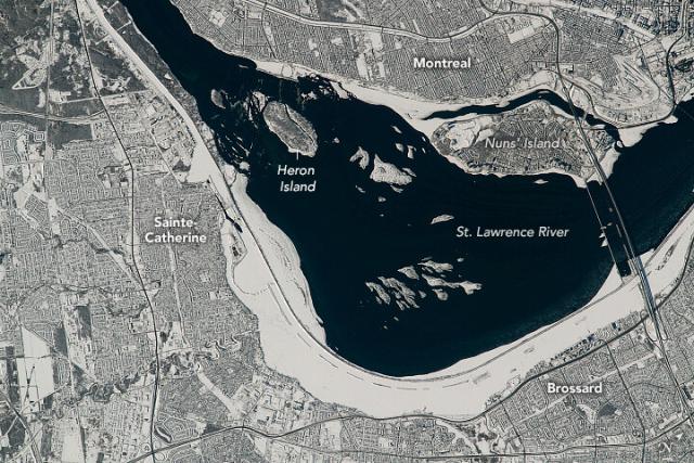
Montreal Islands
Canada’s second-most populous city occupies the largest of hundreds of islands within the Hochelaga Archipelago.go.nasa.gov
#NASAEarth
#NASAEarth
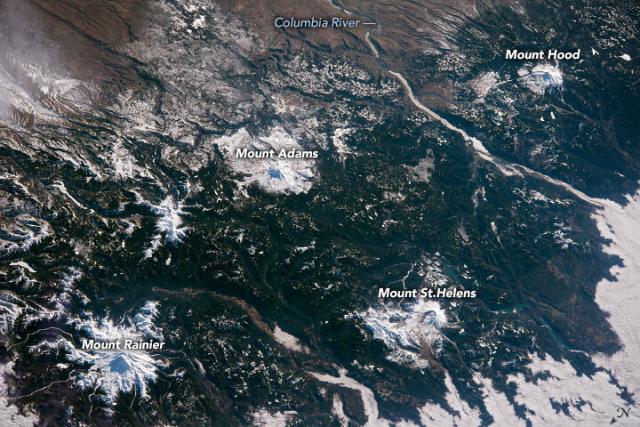
Quartet of Snowy Cascade Volcanoes
Four of the range’s prominent volcanoes—Rainier, St. Helens, Adams, and Hood—were on full display in February 2022.go.nasa.gov
#NASAEarth
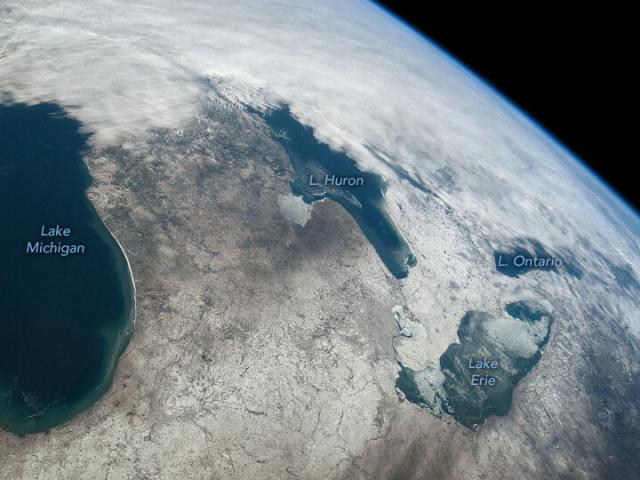
Great Lakes Dressed for Winter
Land and water were decorated with snow and ice when astronauts looked down on the region in February 2022.go.nasa.gov
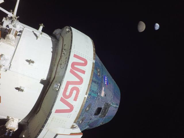
Take in that view 😍
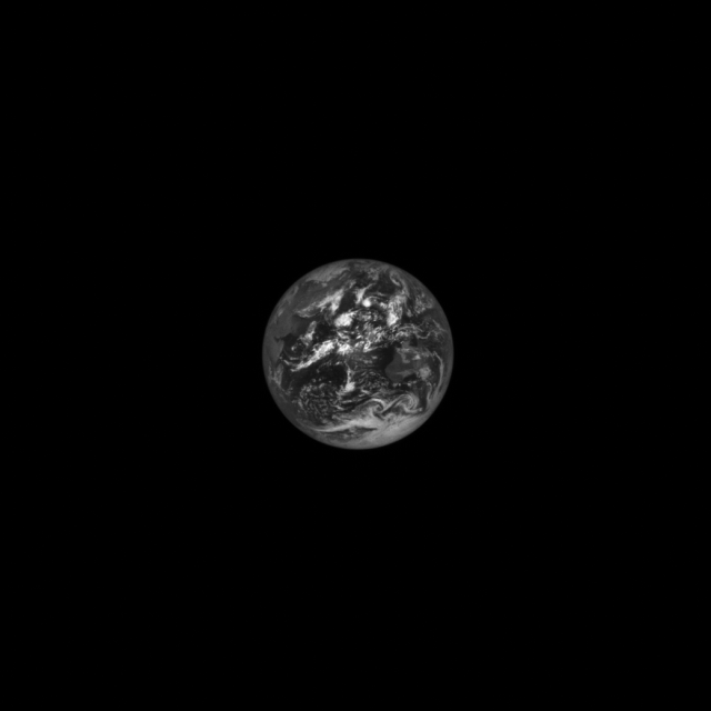
NASA spacecraft returned new, gorgeous sights of our Blue Marble. The photo on the right was captured by @NASA_Orion and the one on the left by the Lucy spacecraft.
#NASAEarth

From on the ground to out in space, we learn something new about our home every day.
Check out some of our Earth highlights from 2022 ⬇️ 🌎
#NASAEarth

#NASAEarth
5 Things to Know About How SWOT Will Look at the World's Water
The international Surface Water and Ocean Topography mission will provide high-definition data on the salt- and fresh water on Earth’s surface.NASA SWOT
We celebrated 50 years of the #Landsat satellite. 🥳
For half a decade, the mission has collected data on Earth’s forests, farms, urban areas, and freshwater, generating the longest continuous record of its kind.go.nasa.gov/3C6Tv7j
#NASAEarth
#NASAEarth
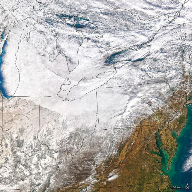
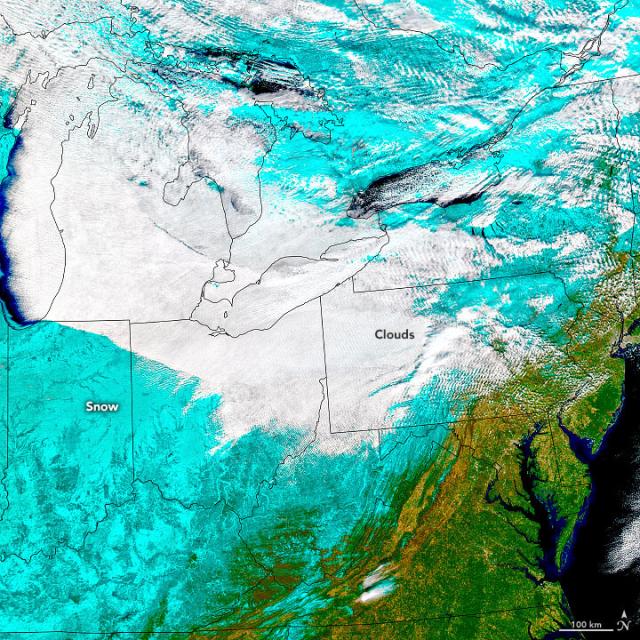
Blizzard Conditions in the U.S. Northeast
An Arctic cold front swept across the Great Lakes and brought fierce winds and potent lake-effect snow.go.nasa.gov
#NASAEarth