Search
Items tagged with: nasaearth

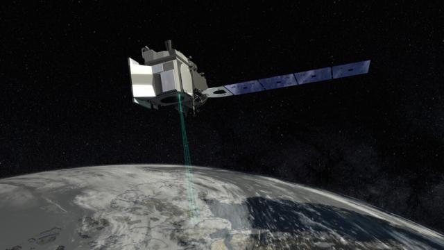
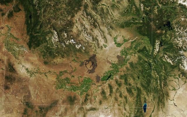
Alaska has nearly 1 million miles of rivers, but only 10% of them are gauged, or measured.
By #TrackingWorldWater, SWOT will measure the height of surface water from space and help groups like the Alaska Department of Fish and Game better manage salmon spawning and survival.
#NASAEarth

SWOT will allow us to see Alaska’s waters in ways we haven’t before, which is important, because Alaska, being in the Arctic, is also where the U.S. is experiencing the most climate change right now.
More: go.nasa.gov/3BtKWmG
#NASAEarth
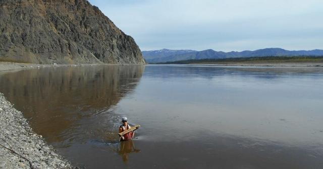
Water Mission to Gauge Alaskan Rivers on Front Lines of Climate Change
The upcoming Surface Water and Ocean Topography mission will provide a trove of data on Earth’s water resources, even in remote locations. Alaska serves as a case study.NASA Sea Level Change Portal
#NASAEarth
#NASAEarth
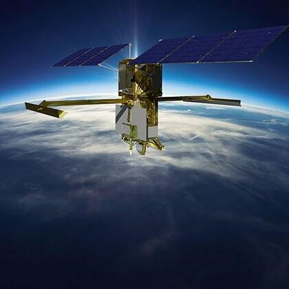
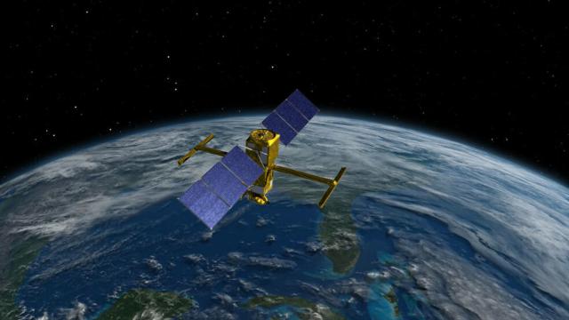
5 Things to Know About How SWOT Will Look at the World's Water
The international Surface Water and Ocean Topography mission will provide high-definition data on the salt- and fresh water on Earth’s surface.NASA SWOT
Today at 11am ET (1600 UTC), @nasa Administrator @SenBillNelson and agency leaders will discuss @NASAClimate research and our role as a global leader in understanding how the planet is changing.
How to watch: go.nasa.gov/3P92hHi
#NASAEarth
NASA to Discuss Climate Research, Mitigation Efforts
NASA Administrator Bill Nelson will discuss the agency’s climate portfolio at 11 a.m. EST on Thursday, Dec. 8 from NASA Headquarters in Washington.Gerelle Dodson (NASA)
Earth has lost 561 square miles (1,453 square kilometers) of salt marshes in the past 20 years, a new @nasa study using #Landsat data shows.
Degrading marsh habitats releases carbon dioxide – a greenhouse gas – into the atmosphere. go.nasa.gov/3UEtIdg
#NASAEarth
NASA Scientists Map Global Salt Marsh Losses and Their Carbon Impact
Earth has lost 561 square miles of salt marshes over the past 20 years, according to a new NASA-led study of the first consistent global accounting of salt marsh locations and changes.Kate Ramsayer (NASA)

#NASAEarth
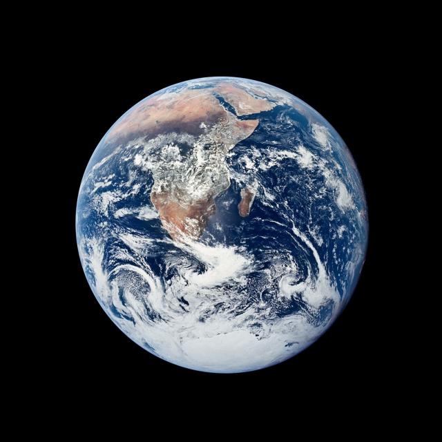
Collection - Earth from Afar
climate change, global climate change, global warming, natural hazards, Earth, environment, remote sensing, atmosphere, land processes, oceans, volcanoes, land cover, Earth science data, NASA, environmental processes, Blue Marble, global mapsearthobservatory.nasa.gov
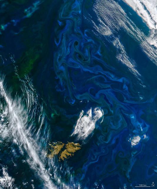
Almost all marine life depends on phytoplankton, tiny plant-like organisms that use chlorophyll to photosynthesize. Scientists track phytoplankton by measuring the concentration of chlorophyll in the water, which @nasa satellites can detect from space.
Breathing Life into the Ocean
Almost all life in the ocean depends on tiny photosynthetic organisms known as phytoplankton.go.nasa.gov
Lots of chlorophyll in the water can indicate a phytoplankton bloom, swirls of blue and green in the ocean that satellites can see from space.
The color of the swirls tells scientists about the plankton in the bloom and nutrient cycling in the ocean.
#NASAEarth
However, NASA’s existing satellites have some limitations to what they can see. The @nasaocean PACE satellite, slated to launch in January 2024, is hyperspectral, meaning it will see the ocean in even more hues.
More on PACE: go.nasa.gov/3VRcfzc
#NASAEarth
NASA PACE - Home
PACE's technologies will provide unprecedented insight into Earth's ocean and atmosphere, which impact life by regulating climate and making Earth habitablego.nasa.gov
The world’s largest active volcano, Mauna Loa, is still erupting.
The @nasa/@USGS Landsat 9 satellite captured this image on Dec. 2. Infrared data from #Landsat’s OLI-2, which detects heat, is overlaid in red, indicating the presence of lava.
🌋: go.nasa.gov/3iEuU2Y
#NASAEarth
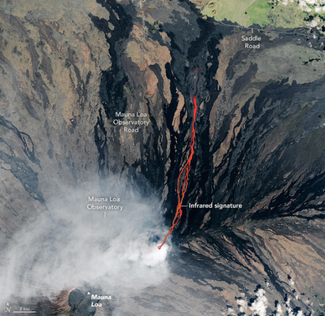
Lava Flows North on Mauna Loa
The Landsat 9 satellite acquired this image of the eruption as lava flowed past the Mauna Loa Observatory toward Saddle Road.go.nasa.gov
We are all connected by water. As we get closer to launching SWOT, we’re focusing on #TrackingWorldWater and want to hear from you! 🌊
Share a photo, video, or questions about the mission and we might share it on the launch broadcast. Submit today ➡️ go.nasa.gov/3usJ368
#NASAEarth
How to Participate in the SWOT Launch – Climate Change: Vital Signs of the Planet
Learn how to participate in the upcoming SWOT launch.Climate Change: Vital Signs of the Planet
An aurora recently dipped south of the Arctic Circle and put on a show over mainland Nunavut and Hudson Bay.
The nighttime light of the aurora was detected by the @noaa @nasa Suomi NPP satellite. go.nasa.gov/3OTHEik
#NASAEarth
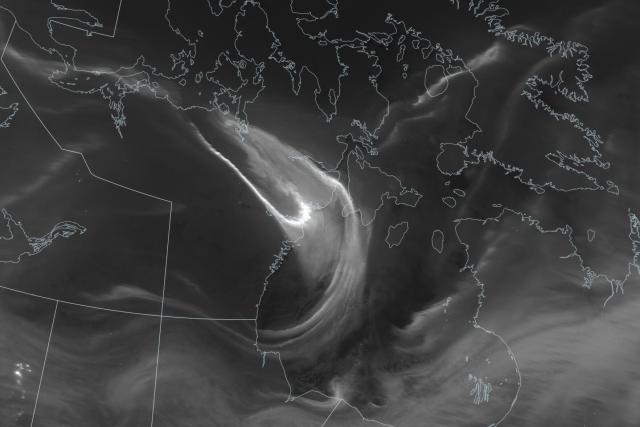
Vibrant Aurora Over Hudson Bay
The light show dipped south of the Arctic Circle, where it was especially bright over northeastern Canada.go.nasa.gov
Under the sea (ice) 🌊 🧊
Floating plant-like organisms called phytoplankton may be abundant underneath Antarctic sea ice, according to a new study using underwater instruments and the @NASA_Ice ICESat-2 satellite. 🛰️
Full story: go.nasa.gov/3OWnkwH
#NASAEarth
Phytoplankton May Be Abundant Under Antarctic Sea Ice, Study Suggests
Scientists using underwater instruments and a NASA satellite have found evidence of potentially significant phytoplankton blooms beneath the sea ice encircling Antarctica.Kate Ramsayer (NASA)
The team used data from Argo floats, underwater instruments that drift and bob with ocean currents.
These devices measure chlorophyll-a and particulate carbon in the water – both factors that indicate phytoplankton are present.
#NASAEarth
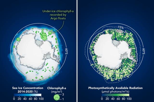
Ice height data from @nasa’s ICESat-2 satellite and ice-cover models allowed the team to map where and how much light was penetrating through thin spots and openings in Antarctic sea ice, and how the ice moved over time.
Learn more: go.nasa.gov/3OWnkwH
#NASAEarth
Phytoplankton May Be Abundant Under Antarctic Sea Ice, Study Suggests
Scientists using underwater instruments and a NASA satellite have found evidence of potentially significant phytoplankton blooms beneath the sea ice encircling Antarctica.Kate Ramsayer (NASA)
Mauna Loa is erupting for the first time in 4 decades, with lava flows reaching 100-200 feet in some cases.
As the volcano began erupting Nov. 27, the @nasa/@NOAA Suomi NPP satellite captured nighttime imagery of the lava’s intensely glowing light & heat. go.nasa.gov/3XDS6hX
#NASAEarth
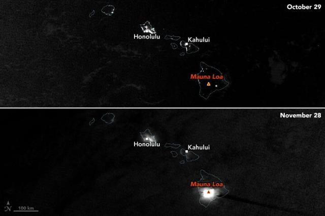
Mauna Loa Awakens
During the first eruption in nearly four decades, satellites observed the volcano’s nighttime glow and sulfur dioxide plume.go.nasa.gov
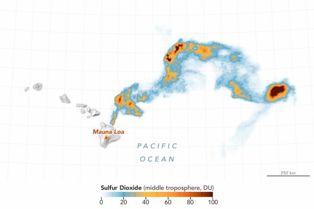
As the volcano erupts, Mauna Loa is emitting sulfur dioxide (SO2), a pungent gas that reacts with oxygen and water to form a gray volcanic haze called vog.
This map shows where the @esa Sentinel-5P satellite detected sulfur dioxide with its TROPOMI sensor.
#NASAEarth
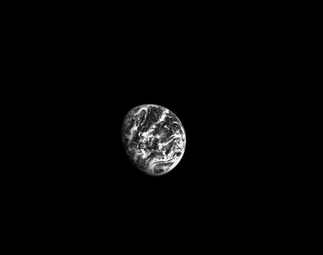
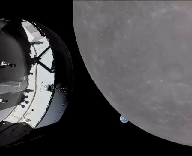
Yesterday, NASA’s uncrewed Orion spacecraft reached its max distance from Earth — 268,563 miles from Earth!
Orion will continue in its distant retrograde orbit for a few more days before swinging by the Moon again on its way back to Earth. 🌏👋🛰🌒
blogs.nasa.gov/artemis/
#NASAEarth
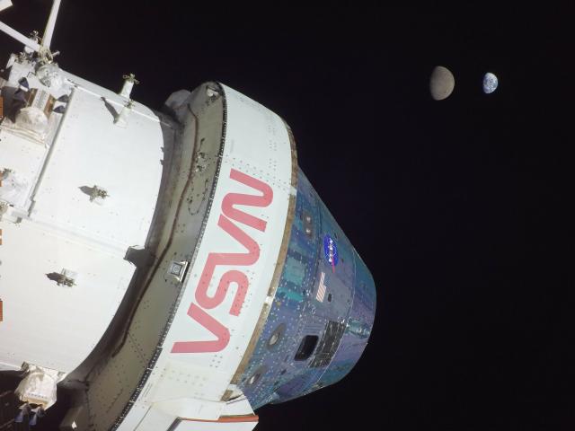
Orion has many cameras that it uses to capture gorgeous imagery of itself as well as Earth and the Moon at different phases and distances.
Images from its optical navigation camera help establish Orion’s position in space, a method that could be useful for future missions.
#NASAEarth
#NASAEarth

NASA to Cancel GeoCarb Mission, Expands Greenhouse Gas Portfolio
NASA announced Monday it intends to cancel development of its GeoCarb mission, and instead implement a plan for pursuing alternate options to measure and observe greenhouse gases.Roxana Bardan (NASA)
The southeastern shore of the Hudson Bay forms a near perfectly curved shoreline.
Called the Nastapoka Arc, this curved shoreline has prompted an ongoing debate over its formation.
Read more about this geologic puzzle: go.nasa.gov/3XS8DPx 🪨 🧩
#NASAEarth
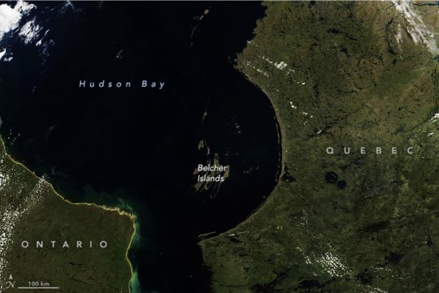
Hudson Bay’s Nastapoka Arc
The origin of this nearly perfectly curved shoreline, a feature not often found in nature, has prompted an ongoing geologic debate.go.nasa.gov
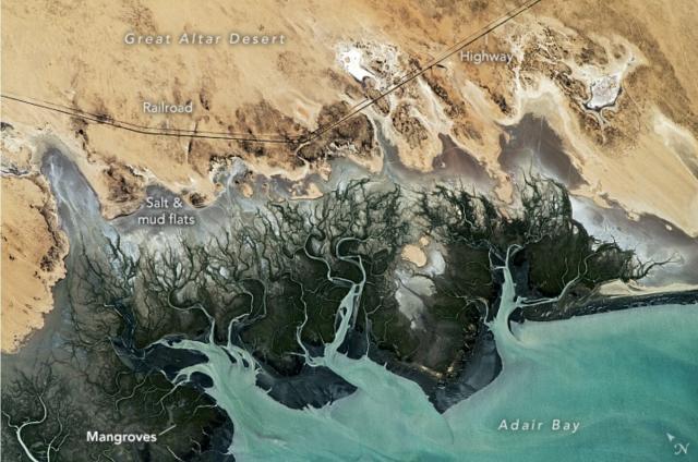
The wetlands of Adair Bay mark the transition between the Great Altar Desert in northwestern Mexico and the Gulf of California.
In this @Space_Station astronaut photo, mangroves and other salt-tolerant plants appear green and blue waterways snake through gray mudflats.
#NASAEarth
We’re only 14 days away from launching SWOT – a new satellite that will track water on nearly 90% of Earth’s surface! 🛰️ 💧
Tag your questions with #TrackingWorldWater by Dec. 5, and they might be answered during our live launch broadcast. go.nasa.gov/3gI3lVP
#NASAEarth
How to Participate in the SWOT Launch – Climate Change: Vital Signs of the Planet
Learn how to participate in the upcoming SWOT launch.Climate Change: Vital Signs of the Planet
NASA precipitation data reporting for duty 🫡
The @usairforce meteorology unit is now using precipitation data from @nasa's IMERG algorithm in its operational weather forecasts and advisories. go.nasa.gov/3ubC2WU
#NASAEarth
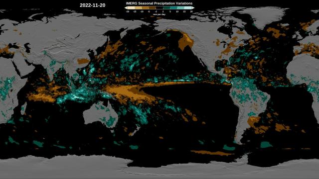
NASA Satellite Precipitation Data Joins the Air Force
Rain gauges are plentiful around the United States, but that’s not the case elsewhere in the world, so scientists and other data users have to rely on satellite measurements, such as those provided by NASA’s GPM to fill in the gaps.Kate Ramsayer (NASA)
Farms in Turkey's district of Elmalı (which means "apple") grow 12% of the country's apples! 🍎
This photo of the region was taken by the @nasa @usgs #Landsat 8 satellite. 📸 🛰
earthobservatory.nasa.gov/imag…
#NASAEarth
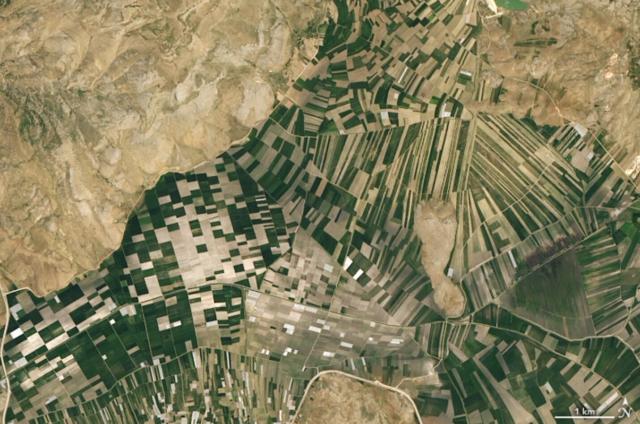
Farming in Turkey’s Mountains
Fruit, grain, and nut farms curve around the western Taurus Mountains in the Antalya province.earthobservatory.nasa.gov
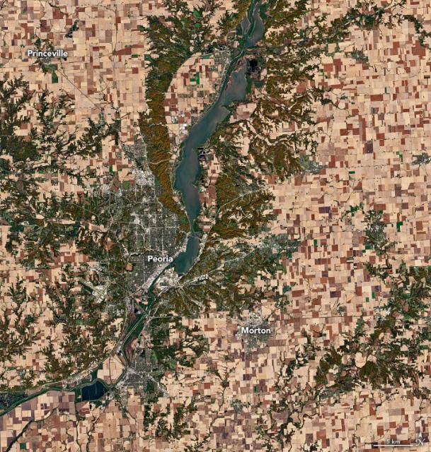
Since the best way to enjoy #Thanksgiving pie is a slice of BOTH apple and pumpkin... 👇
Illinois grows the most pumpkins of any U.S. state by acreage and weight of its harvest. This @nasa/@usgs #Landsat 8 image shows a major hub of pumpkin growing and processing. 🎃
#NASAEarth
earthobservatory.nasa.gov/imag…
#NASAEarth
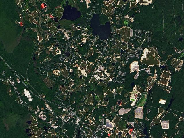
Cranberry Bogs in Plymouth County
Massachusetts has a long-standing relationship with one of Thanksgiving’s iconic foods—the cranberry.earthobservatory.nasa.gov
Astronauts on the @Space_Station grow vegetables to make space salad. 🧑🚀🥗
The ISS also has an instrument called ECOSTRESS that collects thermal data to understand plant stress on Earth! youtube.com/watch?v=WUEFocgIWo…
#NASAEarth

Snacktime with NASA: Space Salad
Snacktime with NASA digs into the science behind what’s on your plate from a tasty cheese board, to seafood, to fresh produce, to chips and dip. Food can bri...YouTube
🥔 go.nasa.gov/3EXjLTK
#NASAEarth
Idaho’s Potato Belt
Almost one-third of American potatoes are grown in the Snake River Plain, a belt of low-lying land in the southern part of the state.go.nasa.gov
What does @nasa have to do with cheese? Corn, soy, alfalfa and other foods for dairy cows all need water to grow.🐄
Some @NASAEarth satellites measure soil moisture or groundwater, helping farmers understand how much water is available for their plants. youtube.com/watch?v=ujOrbk9mJC…
#NASAEarth

Snacktime with NASA: Cheese Board
Snacktime with NASA digs into the science behind what’s on your plate from a tasty cheese board, to seafood, to fresh produce, to chips and dip. Food can bri...YouTube
Over millions of years, the Colorado River carved through ancient sedimentary rocks even as tectonic forces caused the entire landmass to rise. go.nasa.gov/3Ev4LLf
An astronaut on the @Space_Station took this photograph of the river. 🧑🚀 📸
#NASAEarth
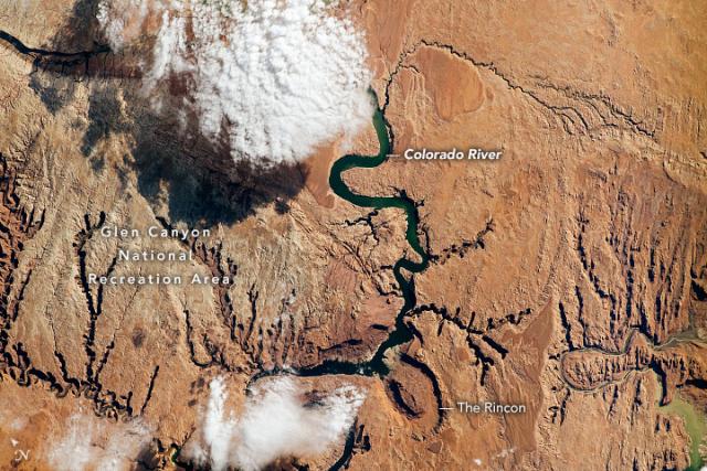
The Colorado River Cuts a Canyon
Over millions of years, the mighty river carved through old sedimentary rocks even as the landmass was rising.go.nasa.gov
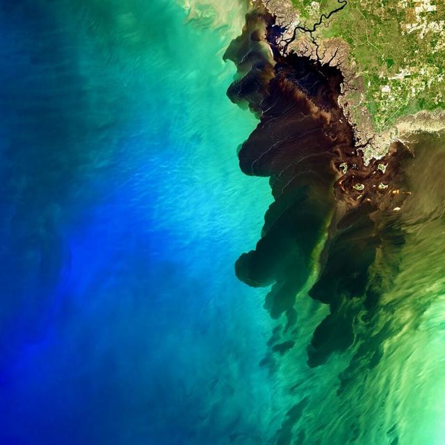
#NASAEarth
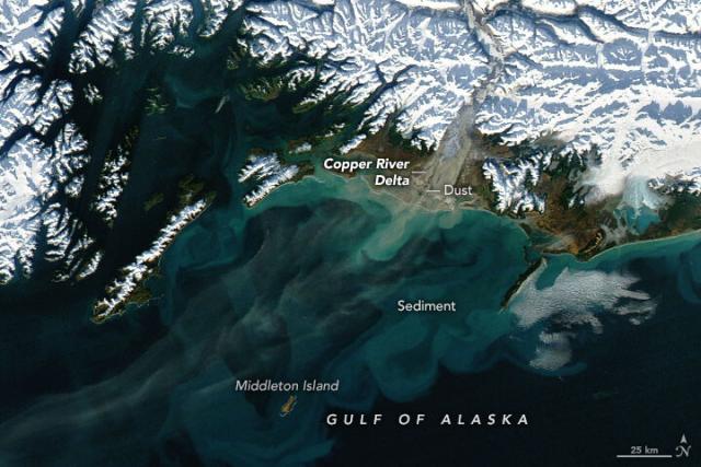
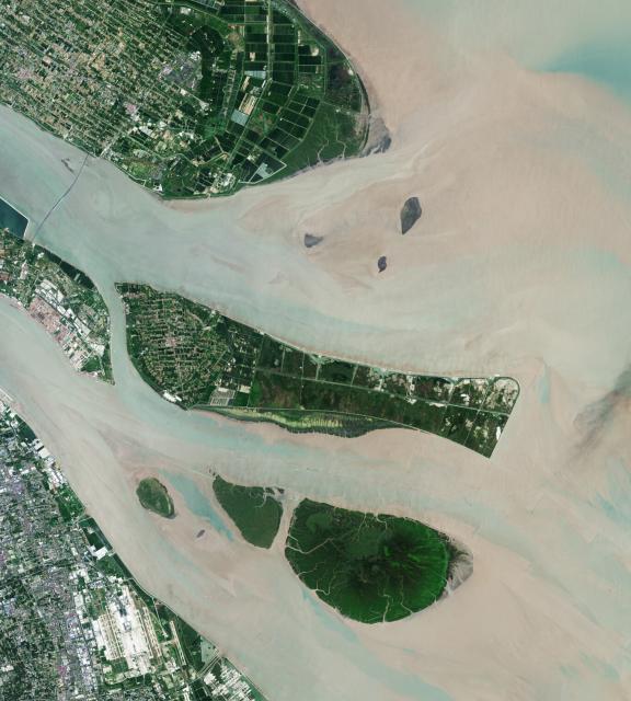
Dusty Copper River Delta
Plumes from this part of Alaska happen in autumn when winds are strong, water levels are low, and snow has not yet blanketed the floodplain.go.nasa.gov
A month at sea 🛥️ 🌊
Scientists with @nasa's S-MODE mission set sail to study how ocean whirlpools drive the transfer of nutrients and energy between the ocean and atmosphere and, ultimately, help shape Earth’s climate.
Dive deeper on the blog: go.nasa.gov/3EMuy2R
#NASAEarth
#NASAEarth
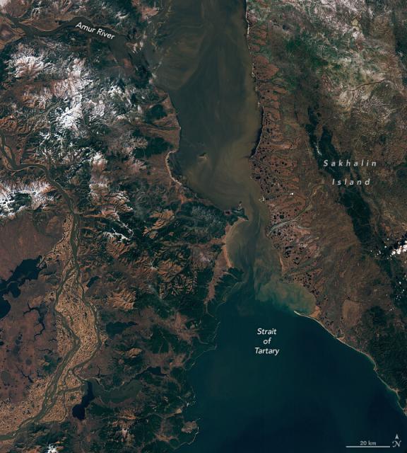
Strait of Tartary in Autumn
Sediment and dissolved organic matter carried by the Amur River contribute to the colorful waters visible in the strait.go.nasa.gov