Search
Items tagged with: landsat

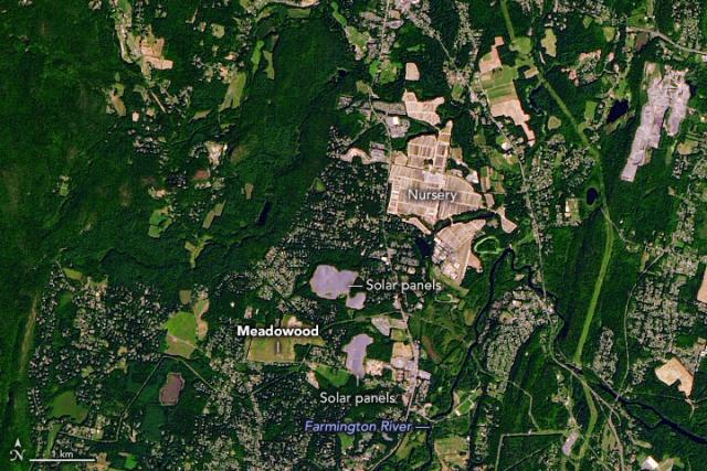
Experiences surrounding Dr. Martin Luther King Jr.’s time spent working on a tobacco farm likely influenced his future as a minister and civil rights activist.
This #Landsat 9 image shows the Meadowood tobacco farm, where King worked, in Simsbury, CT. go.nasa.gov/3X8BbmJ
#NASAEarth

These swirls of discolored water are signs that Kaitoku, a triple-peaked submarine volcano north of Io Jima, is active. 🌊🌋
@nasa’s #Landsat 8 satellite captured these images on Jan. 3, 2023. Activity started in August 2022 has continued periodically. go.nasa.gov/3GFjh4i
#NASAEarth
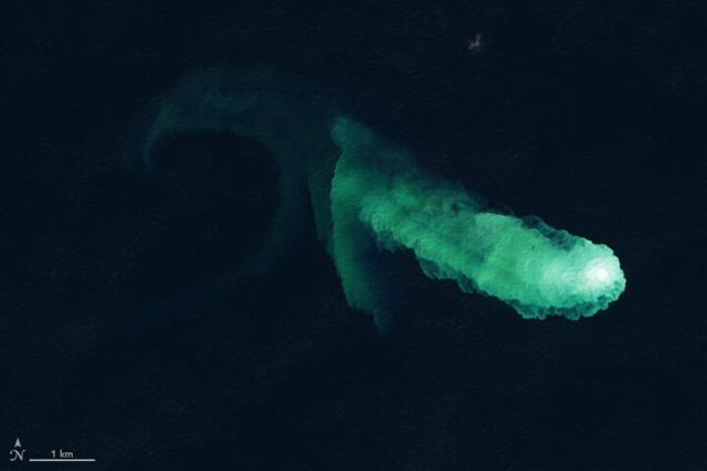
Kaitoku Says Hello
Swirls of discolored water are signs of activity from the underwater volcano.go.nasa.gov
#NASAEarth
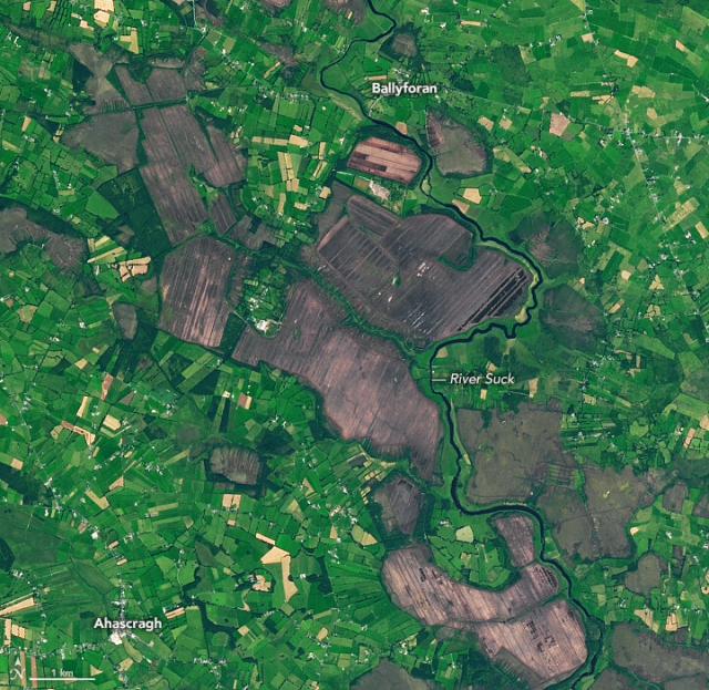
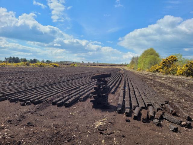
Ireland’s Cutaway Peatlands
Peatlands have been mined in Ireland for centuries, but concern for climate is changing how they are managed.go.nasa.gov
We celebrated 50 years of the #Landsat satellite. 🥳
For half a decade, the mission has collected data on Earth’s forests, farms, urban areas, and freshwater, generating the longest continuous record of its kind.go.nasa.gov/3C6Tv7j
#NASAEarth
#Landsat 8 captured this natural color image of Saba Island, an active stratovolcano located about 140 kilometers east of the U.S. Virgin Islands in the Caribbean Sea.
🌋 go.nasa.gov/3j6wdYV
#NASAEarth
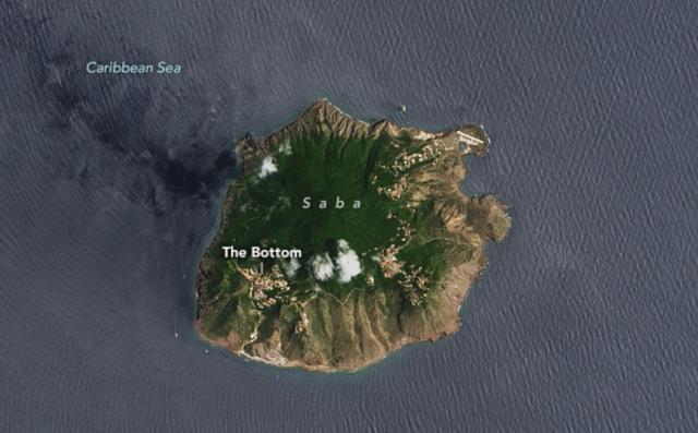
Saba Island
The quiet Caribbean island has been a destination for divers looking to spot corals and sea urchins.go.nasa.gov
#NASAEarth
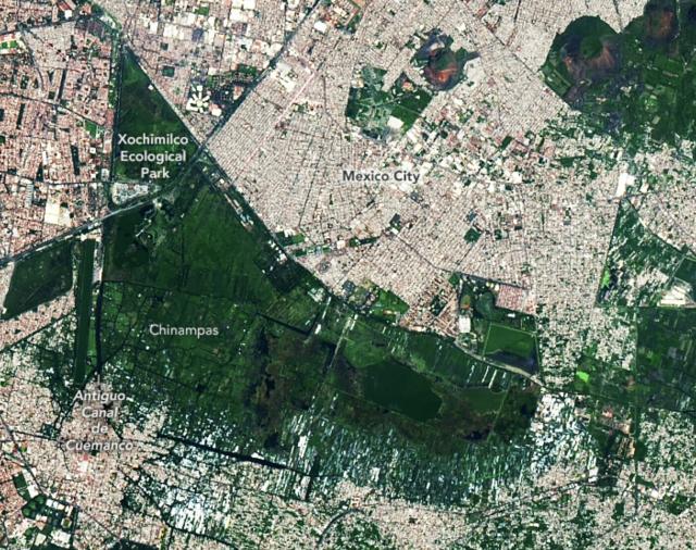
Relic Chinampas in Mexico City
Many of the canals and floating fields used by ancient civilizations in the Valley of Mexico were lost as lakes were drained, but some examples of the watery fields remain in Xochimilco.go.nasa.gov
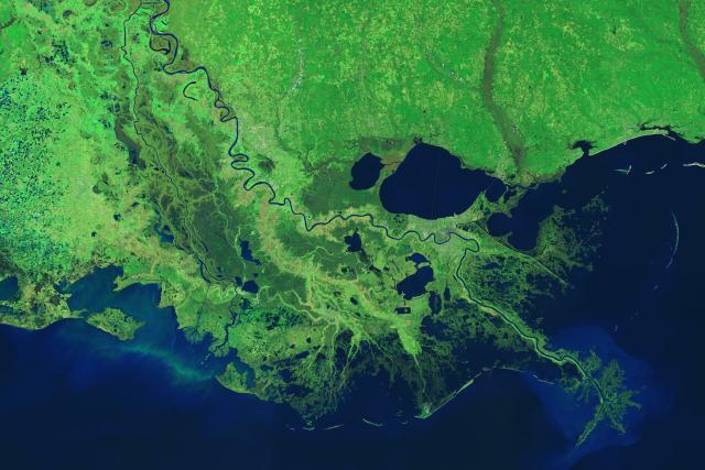
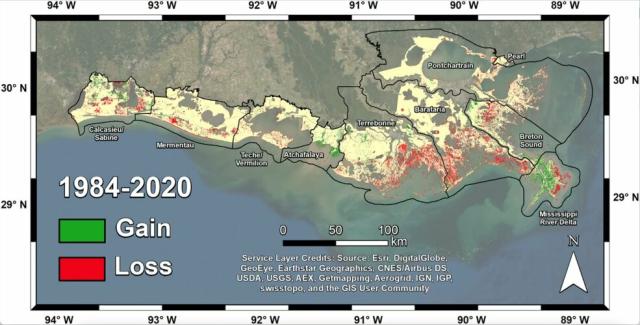
In a new study, scientists used #Landsat imagery from @nasa/@usgs to track shoreline changes and dramatic wetlands losses in Louisiana from 1984 to 2020.
The state lost nearly 21 square miles of important and vulnerable wetland ecosystems every year. go.nasa.gov/3UVZHFN
#NASAEarth
Satellites Help Scientists Track Dramatic Wetlands Loss in Louisiana
New research uses NASA satellite observations and advanced computing to chronicle wetlands lost (and found) around the globe.Kate Ramsayer (NASA)
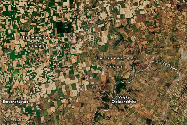
#Landsat 8 captured the image below showing harvested wheat around the town of Bereznehuvate compared to unharvested wheat around Velyka Oleksandrivka.
Satellite data help provide rapid agricultural assessments, important for markets and food security. go.nasa.gov/3HwH3Bs
#NASAEarth
Larger Wheat Harvest in Ukraine Than Expected
A satellite-based analysis indicates that nearly 27 million tons of wheat were harvested from the country’s farms this year, but Ukraine won’t reap all of the benefits.go.nasa.gov
Earth has lost 561 square miles (1,453 square kilometers) of salt marshes in the past 20 years, a new @nasa study using #Landsat data shows.
Degrading marsh habitats releases carbon dioxide – a greenhouse gas – into the atmosphere. go.nasa.gov/3UEtIdg
#NASAEarth
NASA Scientists Map Global Salt Marsh Losses and Their Carbon Impact
Earth has lost 561 square miles of salt marshes over the past 20 years, according to a new NASA-led study of the first consistent global accounting of salt marsh locations and changes.Kate Ramsayer (NASA)
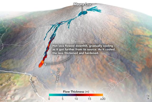
The world’s largest active volcano, Mauna Loa, is still erupting.
The @nasa/@USGS Landsat 9 satellite captured this image on Dec. 2. Infrared data from #Landsat’s OLI-2, which detects heat, is overlaid in red, indicating the presence of lava.
🌋: go.nasa.gov/3iEuU2Y
#NASAEarth
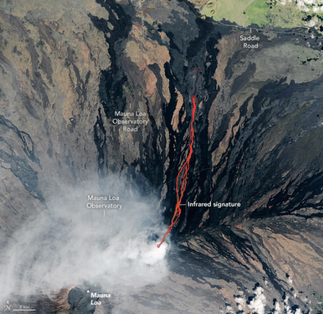
Lava Flows North on Mauna Loa
The Landsat 9 satellite acquired this image of the eruption as lava flowed past the Mauna Loa Observatory toward Saddle Road.go.nasa.gov
Farms in Turkey's district of Elmalı (which means "apple") grow 12% of the country's apples! 🍎
This photo of the region was taken by the @nasa @usgs #Landsat 8 satellite. 📸 🛰
earthobservatory.nasa.gov/imag…
#NASAEarth
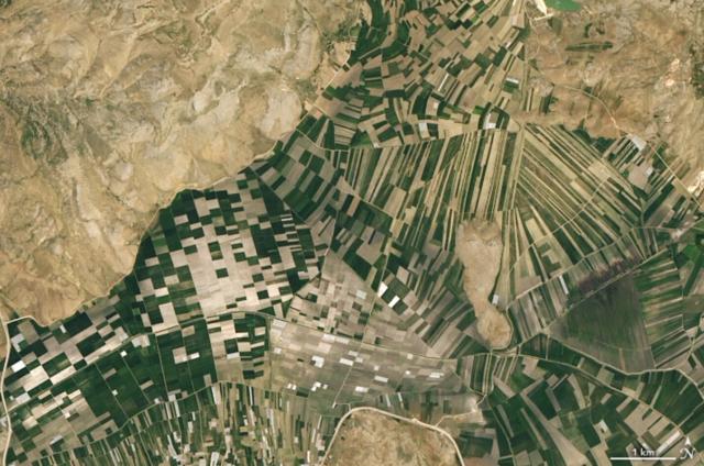
Farming in Turkey’s Mountains
Fruit, grain, and nut farms curve around the western Taurus Mountains in the Antalya province.earthobservatory.nasa.gov
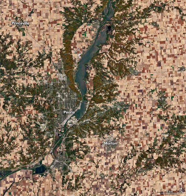
Since the best way to enjoy #Thanksgiving pie is a slice of BOTH apple and pumpkin... 👇
Illinois grows the most pumpkins of any U.S. state by acreage and weight of its harvest. This @nasa/@usgs #Landsat 8 image shows a major hub of pumpkin growing and processing. 🎃
#NASAEarth
earthobservatory.nasa.gov/imag…
#NASAEarth
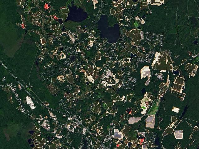
Cranberry Bogs in Plymouth County
Massachusetts has a long-standing relationship with one of Thanksgiving’s iconic foods—the cranberry.earthobservatory.nasa.gov
#NASAEarth
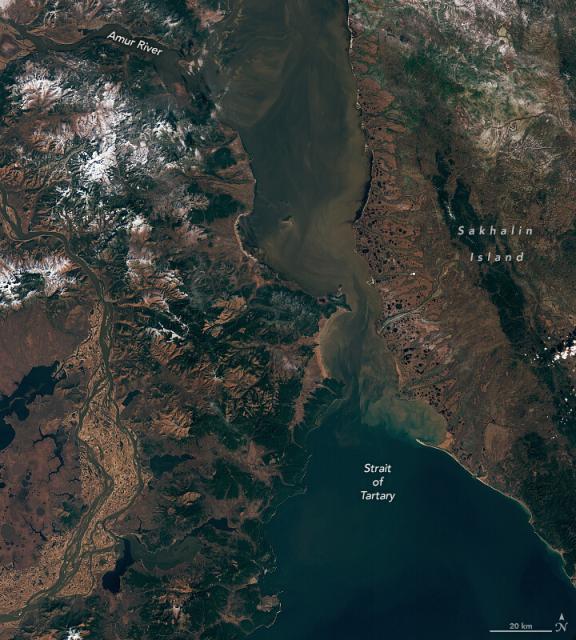
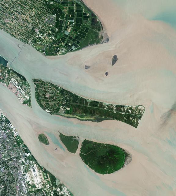
Strait of Tartary in Autumn
Sediment and dissolved organic matter carried by the Amur River contribute to the colorful waters visible in the strait.go.nasa.gov
#NASA