Search
Items tagged with: nasaearth
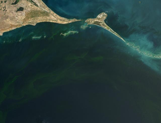
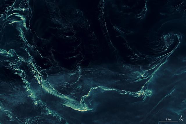
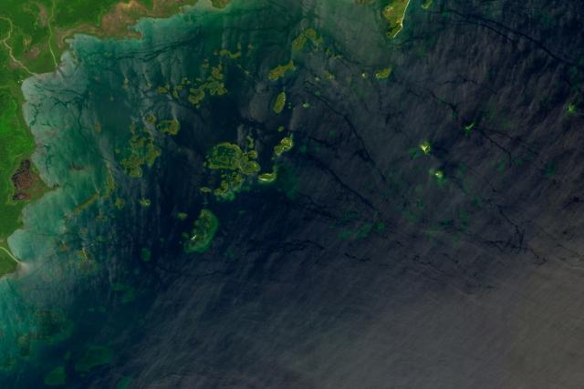
Multiple studies show dangerous algae blooms have become more frequent and intense in the Gulf of Mannar since 2019.
This #Landsat 9 image from Sep. 23, 2022 shows a bloom in the Gulf of Mannar, off the southeastern coast of India. go.nasa.gov/42xvhhx
#NASAEarth
Deadly Blooms in the Gulf of Mannar
Though Noctiluca scintillans blooms have long been noted in the shallow gulf, they have become more frequent and intense since 2019.go.nasa.gov
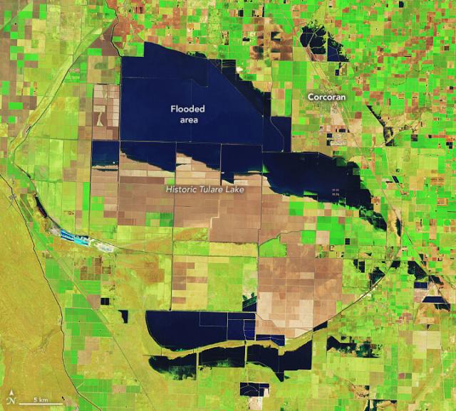
Update on Tulare Lake: still growing.
The historic lakebed, now covered with farms that grow a variety of crops, is flooded after two major storms hit southern California. This enhanced-color image by #Landsat highlights the water in dark blue. go.nasa.gov/3NKKJCH
#NASAEarth
Tulare Lake Grows
Flooding in the California lakebed continues to spread as spring brings snowmelt from the Sierras.go.nasa.gov
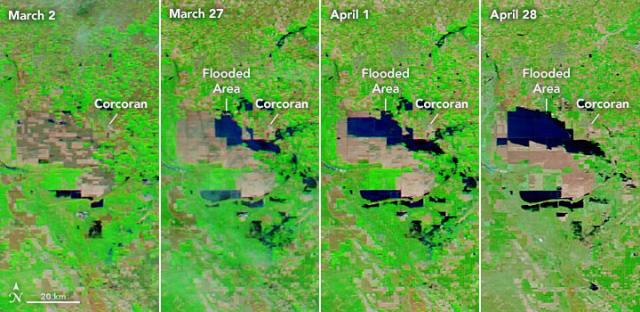
NASA’s Aqua satellite captured the progression of flooding in the Tulare Lake basin from March 2 to April 28.
Flooding in the lakebed is likely to continue into 2024, which will affect residents and farmers in the area. go.nasa.gov/3NKKJCH
#NASAEarth
Tulare Lake Grows
Flooding in the California lakebed continues to spread as spring brings snowmelt from the Sierras.go.nasa.gov
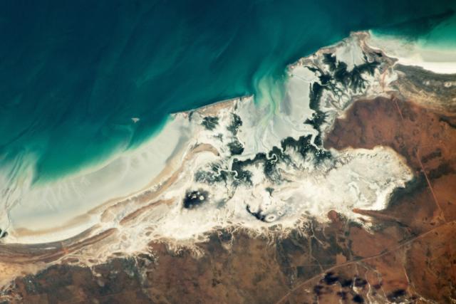
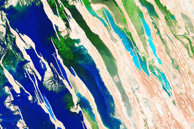
Eighty Mile Beach Marine Park is an example of an intertidal zone ecosystem. Near low tide, the ebb current moves seawater toward the Indian Ocean and exposes salt flats, intertidal flats, and mangrove forests. go.nasa.gov/3NBIKka
📍: Australia
📷: @Space_Station astronaut
#NASAEarth
Mangroves on Eighty Mile Beach
Trees along this stretch of western Australia have an elongated root system that allows them to withstand high and low tides.go.nasa.gov
Better together ❤️
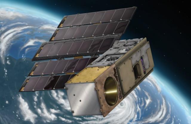
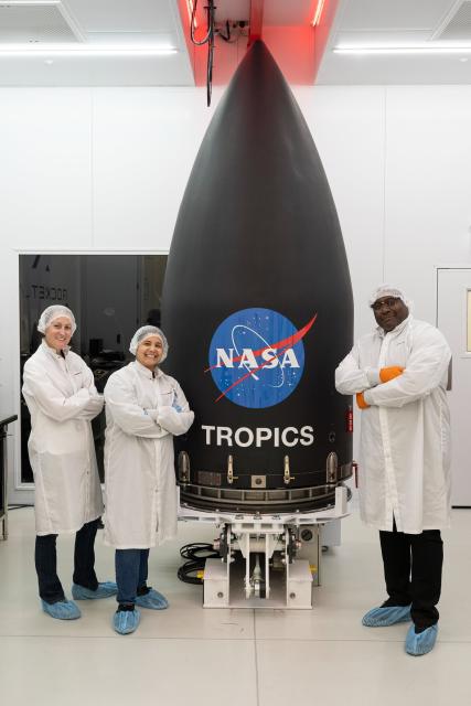
With four small satellites orbiting as a constellation, @nasa’s TROPICS mission will study hurricanes like never before.
@RocketLab is planning to launch the first pair of CubeSats starting at 9pm EDT on May 7. go.nasa.gov/3ph3tPW
#NASAEarth
NASA, Rocket Lab Update Launch Coverage for Tropical Cyclones Mission
After the previous launch target date changed due to weather conditions in New Zealand, NASA and Rocket Lab are now targeting 9 p.m. EDT Sunday, May 7, (1 p.m.Abbey Donaldson (NASA)
In Southeast Asia, water managers are using satellite data to help predict extreme rainfall, track reservoir levels, & more.
The work is through @nasa @usaid's SERVIR program, which recently expanded to countries like Indonesia and the Philippines. go.nasa.gov/3nyK8cM
#NASAEarth
Satellite Data, Applications Flowing Through SERVIR to Southeast Asia
ith customized tools that use NASA observations and data, the people who manage the Mekong River water supply have been improving their decision-making.Beth Ridgeway (NASA)
#MayThe4thBeWithYou! ⭐⚔️
Last summer, @nasa ABoVE scientists studied how climate change is affecting the Arctic and boreal forests in Alaska and Canada.
On Aug. 22, 2022, they took a break and fought an epic battle… #StarWarsDay
#NASAEarth
The Dark Canyon complex cuts through southeastern Utah in this @Space_Station photo.
The area has deep canyons and steep sandstone walls and is part of Bears Ears National Monument, home to many cultural and archaeological sites. go.nasa.gov/3LxePGW
#NASAEarth
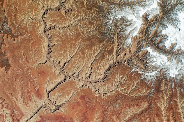
Utah’s Dark Canyon Complex
Petroglyphs, hanging gardens, and deep canyons make this remote landscape a notable part of Bears Ears National Monument.go.nasa.gov
Meet Amber Soja, a @NASA_Langley scientist! 👋
She uses NASA satellite data, ground sensors, and field campaigns to create a comprehensive global picture of fires. This helps scientists understand how smoke affects air quality and human health. go.nasa.gov/42cckRT 🔥 #AQAW
#NASAEarth
🔗earthobservatory.nasa.gov/imag…
#NASAEarth
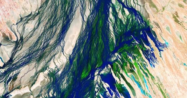
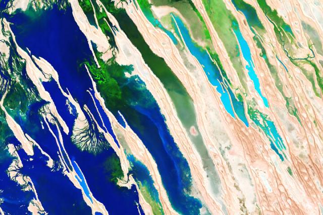
Seasonal Flooding of the Diamantina River
False-color images from Channel Country in the Australian Outback reveal a barren landscape transformed.earthobservatory.nasa.gov
Yup, it’s allergy season. 🌼🌲
Pine pollen floating on the currents and waves is responsible for these patterns in the Baltic Sea, taken by the @esa Sentinel-2A satellite in May 2018. go.nasa.gov/42dRCAA
#NASAEarth
Sea of Pollen Visible From Space
Researchers used satellites to distinguish blankets of pine pollen from other floating materials on the Baltic Sea.go.nasa.gov
Scientists are using artificial intelligence to analyze 50 years’ worth of @usgs @NASA_Landsat data. 🌏 🛰️
These tools help scientists identify cloud cover or wildfire smoke in #Landsat images, map changes in land cover, and more. go.nasa.gov/3HsiNzB
#NASAEarth
From Orbit to A.I.—Harnessing Machine Learning with Landsat Data | Landsat Science
Over the past few years, machine learning techniques have been increasingly used to analyze the vast amount of data collected by the Landsat mission, which has been circling the globe for over 50 years.https://landsat.gsfc.nasa.gov/article/author/lrocchio/#author (Landsat Science)
#ICYMI the northern lights put on quite a display last week! 🤩
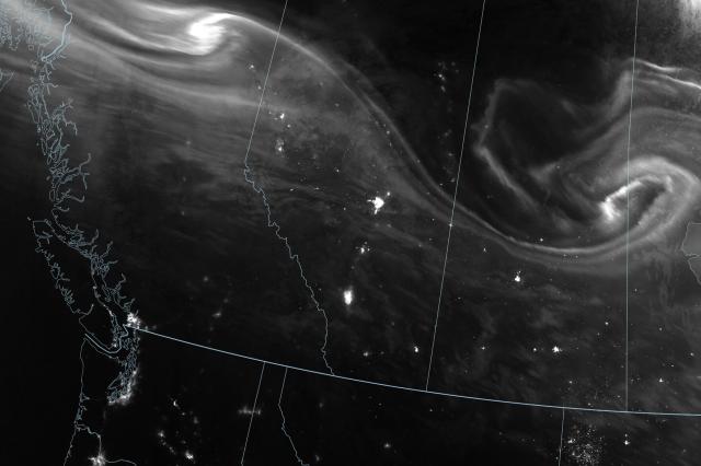
A geomagnetic storm led to dazzling lights as far south as Arizona and Arkansas.
The @noaa @nasa Suomi NPP satellite captured the aurora in black and white over Canada on April 24, 2023. go.nasa.gov/427o6fR
#NASAEarth
An Awesome Aurora
Events on the Sun helped unleash beautiful displays of nighttime lights seen on Earth.go.nasa.gov
Coral reefs in the Port Honduras Marine Reserve are exposed to warm water and low water clarity more than any other reserve in Belize. Poor water clarity—typically caused by runoff after heavy rains—can prevent corals from getting enough light.
Port Honduras Marine Reserve
Coral reefs in this marine reserve have more exposure to warm water and low water clarity than any other reserve in Belize.go.nasa.gov
Bloom like nobody’s watching ⭐️
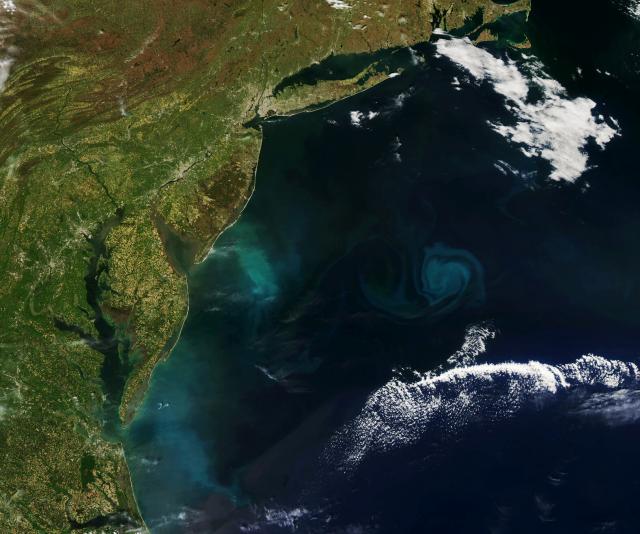
NASA’s Aqua satellite watched the U.S. Mid-Atlantic coast dazzle with swirls of green and turquoise, in part from a phytoplankton bloom. Though phytoplankton are microscopic, large groups of them are visible from space. go.nasa.gov/3ngVyBJ
#NASAEarth
Bloomin’ Atlantic
Abundant phytoplankton swirled in the waters off the U.S. Mid-Atlantic coast in spring 2023.go.nasa.gov
The Canadian Rockies 🏔️
An astronaut on the @Space_Station took this photo of the Canadian Rockies, part of North America’s largest mountain range that sprawls approximately 4,800 kilometers (3,000 miles) long.
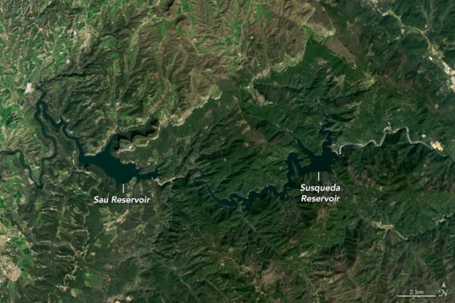
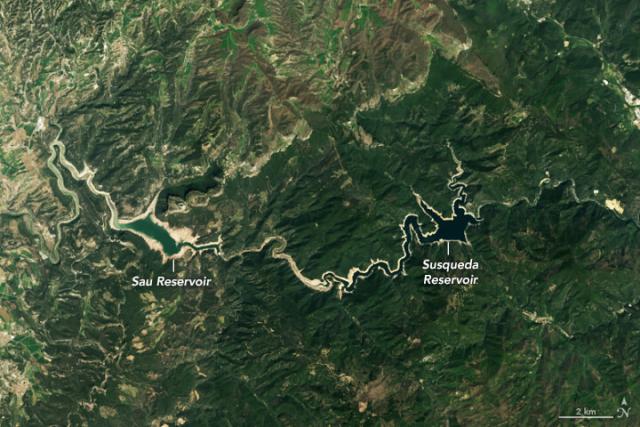
The Catalonia region of Spain is experiencing a long-term drought.
These #Landsat 8 images show the Sau and Susqueda Reservoirs in 2021 (left) and in April 2023 (right), which both have diminished water levels. go.nasa.gov/44bzrx6
#NASAEarth
Shrinking Reservoirs in Catalonia
Heat and drought have parched reservoirs in northeastern Spain.go.nasa.gov
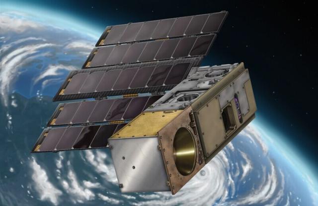
Four CubeSats, one mission: to study tropical cyclones, like hurricanes. 🌀🌧️
NASA’s TROPICS mission is a constellation of small satellites, with the first of two launches scheduled for April 30, 2023.
Here are four things to know about TROPICS 👇
#NASAEarth
TROPICS will help scientists understand how tropical cyclones form and develop.
The satellites will collect information about a storm’s precipitation, temperature, and humidity – all important factors for the strength and longevity of a storm.
#NASAEarth
TROPICS will orbit Earth in two planes, collecting data on these storms nearly every hour and improving weather forecasts.
Current satellites provide information about a given storm about every six hours.
#NASAEarth
#NASAEarth
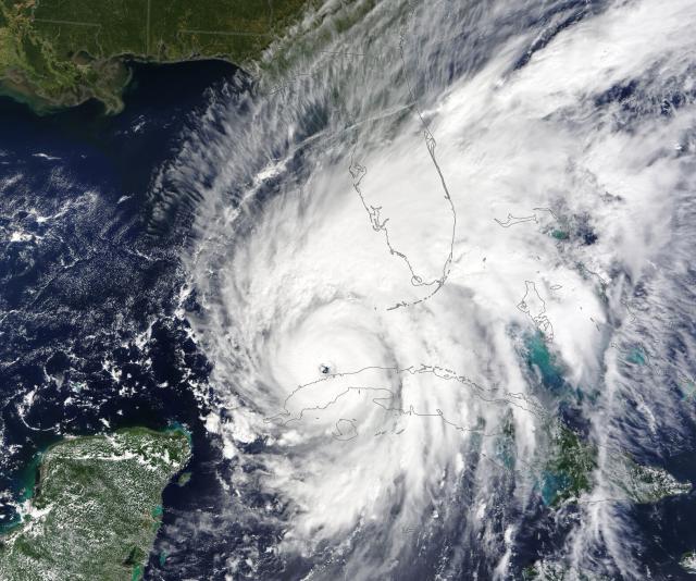
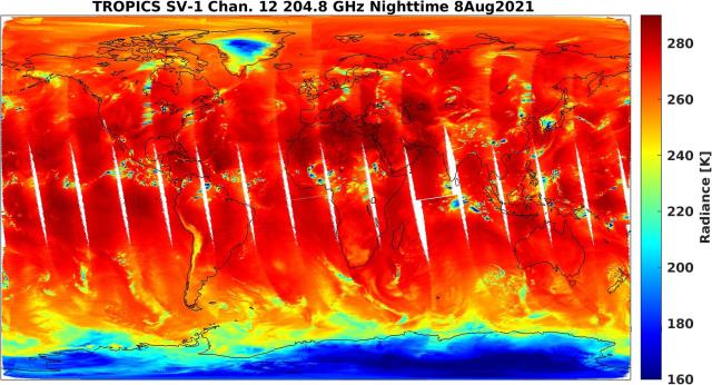
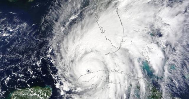
NASA’s TROPICS Pathfinder Satellite Produces Global First Light Images
On August 8, NASA’s TROPICS Pathfinder satellite captured global first light images as well as a look inside the structure of Hurricane Ida before and after it made landfall.Sofie Bates (NASA)
The first constellation launch is scheduled for Sunday, April 30 NET 9 p.m. EDT from New Zealand. The second launch is targeted for Tuesday, May 16 EDT.
Read the blog: go.nasa.gov/44dVX8s
Or follow @nasa and @nasa_LSP for updates! 🚀 go.nasa.gov/41ProVa
#NASAEarth
NASA, Rocket Lab Set Coverage for Tropical Cyclones Mission
NASA and Rocket Lab are targeting 9 p.m. EDT, Sunday, April 30 (1 p.m. New Zealand Standard Time, Monday, May 1), to launch two storm tracking CubeSats into orbit.Abbey Donaldson (NASA)
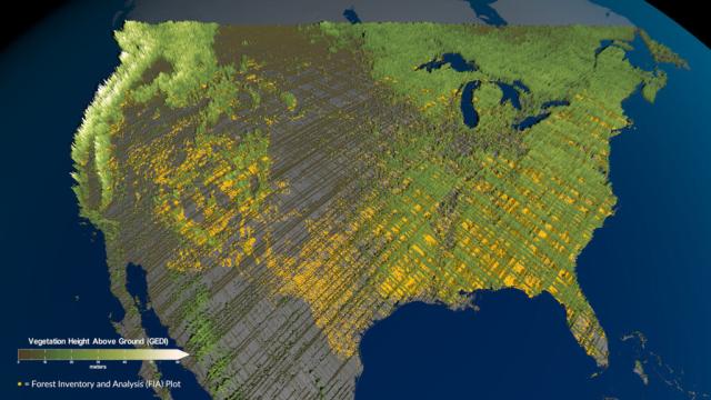
Scientists at @nasa teamed up with the @forestservice to create the first-ever inventory of mature, old-growth forests in the U.S.
This visualization shows vegetation height across the U.S. (shown in green, with lighter color indicating taller trees). go.nasa.gov/3oLcvVg
#NASAEarth
NASA Teams with Forest Service to Tally America’s Oldest Trees
The White House has called for an inventory of our eldest forests. A space instrument is helping scientists chronicle these trees as a changing climate threatens their future.Jennifer Fadoul (NASA)
Forests do a lot for us , from cleaning our air and water to providing nature and beauty. #ArborDay 🌲🌳
America’s forests also absorb over 10% of annual greenhouse gas emissions, and old-growth forests generally store more carbon than younger forests. go.nasa.gov/3oLcvVg
#NASAEarth
NASA Teams with Forest Service to Tally America’s Oldest Trees
The White House has called for an inventory of our eldest forests. A space instrument is helping scientists chronicle these trees as a changing climate threatens their future.Jennifer Fadoul (NASA)
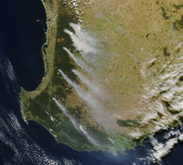
In Australia, plentiful rainfall set the stage for prescribed burning to begin. Though the fires were planned, winds can still carry the smoke far from the source.
NASA’s Aqua satellite captured the trailing smoke from space on April 23, 2023. go.nasa.gov/40DOblz
#NASAEarth
Smoky Skies in Western Australia
Wet weather set the stage for prescribed burning to ramp up through April 2023 in the state’s southwest, near Perth.go.nasa.gov
TROPICS is a constellation of CubeSats that will help us better understand tropical storms and hurricanes around the globe. The first of two launches is set for April 30th.
🌀 Have questions? Use #AskNASA and we may answer them during the live broadcast.
nasa.gov/press-release/nasa-ro…
#NASAEarth
NASA, Rocket Lab Set Coverage for Tropical Cyclones Mission
NASA and Rocket Lab are targeting 9 p.m. EDT, Sunday, April 30 (1 p.m. New Zealand Standard Time, Monday, May 1), to launch two storm tracking CubeSats into orbit.Abbey Donaldson (NASA)
#NASAEarth
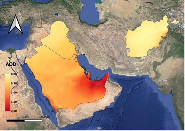
Veterans’ Exposure to Smoke and Air Pollution Tracked by NASA Data
Researchers with the U.S. Department of Veterans Affairs are using NASA Earth observations of smoke and other air pollution to study the health impacts on veterans who were deployed to Afghanistan, Iraq, and other areas of Southwest Asia in the years…Aries Keck (NASA)
#NASAEarth
VP Harris, South Korea President Yoon Visit NASA Goddard
Vice President Kamala Harris and Republic of Korea (ROK) President Yoon Suk Yeol saw firsthand how NASA studies climate change during a visit to NASA’s Goddard Space Flight Center in Greenbelt, Maryland, this afternoon.Rob Garner (NASA)
#NASAEarth
New Instrument to Track Pollution Hourly, Shed Light on Disparities
NASA is preparing for the launch of an instrument that will provide new insight into air quality in North America, observing air pollution from space more frequently and in greater detail than previous space-based instruments.Joe Atkinson (NASA)
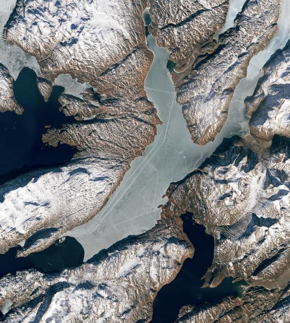
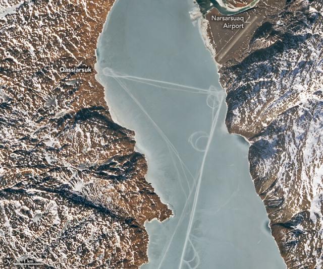
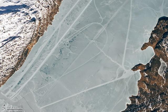
What are these marks in the ice? 🤔
On March 13, 2023, #Landsat 9 took these images of Tunulliarfik Fjord in Greenland. At the time, the fjord’s waters were capped with a layer of sea ice. 🌊🧊 go.nasa.gov/3V4P0m6
#NASAEarth
Curious Tracks Criss-Cross an Icy Fjord
Paths that cut across the still-frozen Tunulliarfik Fjord in southern Greenland were likely made by people.go.nasa.gov
Some of the lines connect the towns of Qassiarsuk (left) and Narsarsuaq (right), which are about 4 kilometers (2.5 miles) apart across the fjord.
@NASAGoddard ice scientists believe these lines and loops were likely produced by humans on snowmobiles.
#NASAEarth
🧊 However, some of the “lines” in this image have more variation.
“These look like natural ice deformation features, most likely cracks or ridging due to tidal motion,” said @nasagoddard cryospheric scientist Nathan Kurtz.
#NASAEarth
Learn how pan-sharpening works: 🔍 go.nasa.gov/3AA2pch
#NASAEarth
Earth Matters - How to Pan-sharpen Landsat Imagery
climate change, global climate change, global warming, natural hazards, Earth, environment, remote sensing, atmosphere, land processes, oceans, volcanoes, land cover, Earth science data, NASA, environmental processes, Blue Marble, global mapsgo.nasa.gov
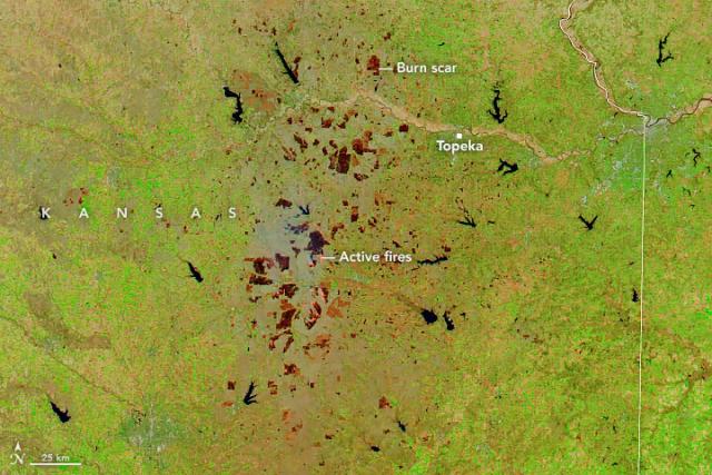
As fires burned across eastern Kansas in March and April, they left a patchwork of scars that can be seen from space.
Enhanced-color images taken by NASA satellites highlight burn scars and active fire fronts: go.nasa.gov/3V8CZwc
#NASAEarth
Where in the world is this? 🤩
Guess our April puzzler and tell us where this is on Earth, what we’re looking at, and why it’s important. 🧩
Earth Matters - April Puzzler
climate change, global climate change, global warming, natural hazards, Earth, environment, remote sensing, atmosphere, land processes, oceans, volcanoes, land cover, Earth science data, NASA, environmental processes, Blue Marble, global mapsgo.nasa.gov
#NASAEarth
