Search
Items tagged with: nasaearth

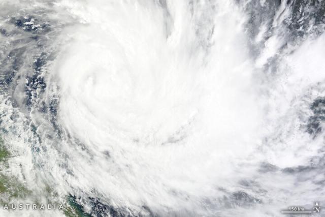
Fierce storms over the ocean can dislodge carbonate sediment – like from coral, algae and hard shells of marine life – from shallow water and move it deeper into the ocean.
This process may have important implications for ocean acidification. go.nasa.gov/3Gro3Ts 🌊🪸🐚
#NASAEarth
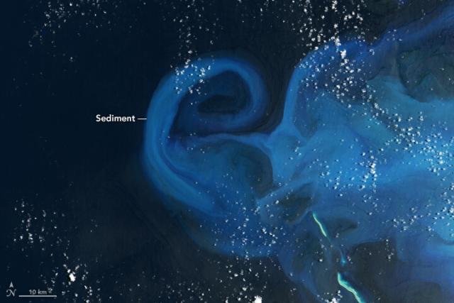
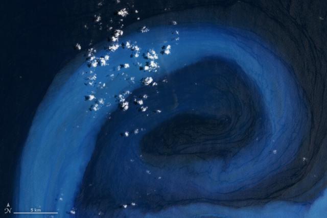
Stirring Up Carbonate in the Coral Sea
Fierce storms can dislodge carbonate sediment from shallow underwater platforms and move it into deeper waters.go.nasa.gov

In Feb. 2023, Tropical Cyclone Gabrielle passed over shallow waters at the Bellona Plateau in the Coral Sea.
The storm suspended carbonate sediment that then drifted into deep ocean waters.
#NASAEarth
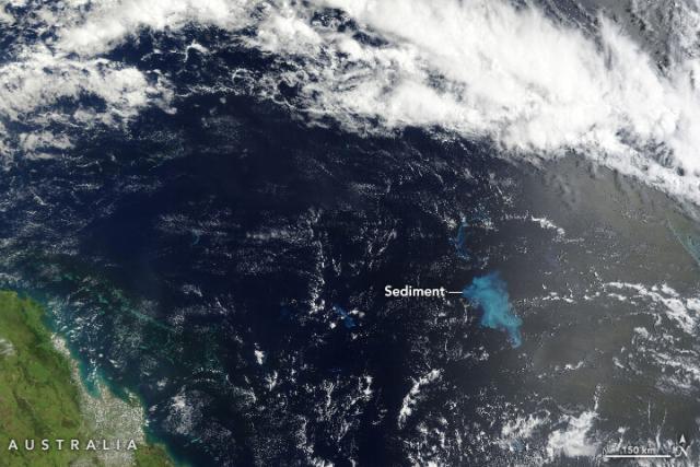
This process can help counter ocean acidification from rising carbon dioxide in the atmosphere.
But scientists are still investigating how climate change might be changing the marine carbon cycle. go.nasa.gov/3Gro3Ts
#NASAEarth
Stirring Up Carbonate in the Coral Sea
Fierce storms can dislodge carbonate sediment from shallow underwater platforms and move it into deeper waters.go.nasa.gov
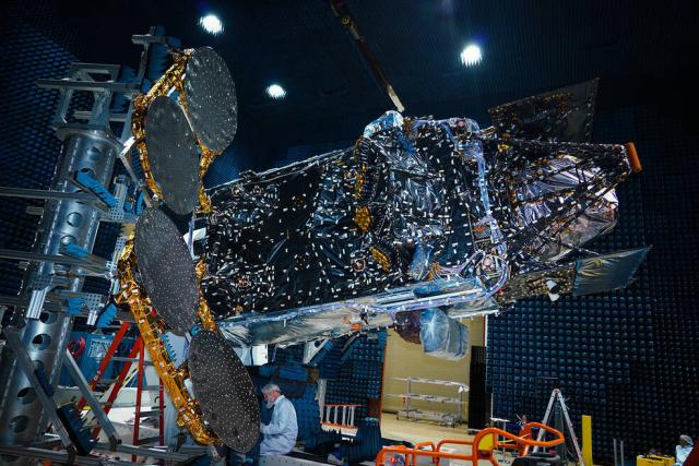
Staying up late? Watch the TEMPO launch! 🚀
TEMPO is a @nasa and @CenterForAstro mission to study air quality over North America every hour. It’s launching on a @SpaceX Falcon 9 rocket.
12am ET (4am tomorrow UTC) 🕛
Watch: nasa.gov/nasalive 📺
#NASAEarth
Using two decades of NASA satellite data, scientists assessed the risks Belize’s coral reefs face from murky waters and rising temperatures.
The findings could help protect reefs around the world from overfishing, pollution, and climate change. Details: go.nasa.gov/3nNiuZl
#NASAEarth
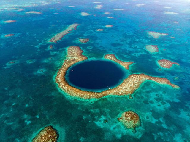
Scientists Use NASA Satellite Data to Determine Belize Coral Reef Risk
Researchers created a toolkit for determining the clarity and surface temperature of coastal waters. The data is freely accessible data and can help assess reefs around the world.Tony Greicius (NASA)
Did you guess the puzzler?
It’s Crater Lake in Oregon! At 1,943 feet (592 meters) deep, Crater Lake is the deepest lake in the United States and among the deepest in the world. #Landsat captured this picture of the lake on March 18, 2023.
🔗earthobservatory.nasa.gov/imag…
#NASAEarth
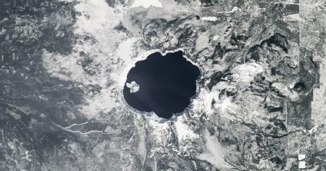

A Clear View of Crater Lake
The lake is especially scenic in early spring when its deep-blue waters contrast with a blanket of snow on land.earthobservatory.nasa.gov
#Landsat captured a tornado’s path of destruction across Arkansas.
Severe thunderstorms tore through the U.S. Midwest and Mid-South where they spawned dozens of tornadoes across seven states. go.nasa.gov/3MlnoHf
#NASAEarth

Tornado Razes a Path Through Wynne
A path of destruction across the Arkansas town is visible to Landsat after another tornado outbreak swept across parts the U.S.go.nasa.gov
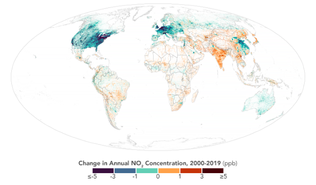
Nitrogen dioxide is largely produced from vehicle emissions.
The team estimated that 1.85 million new asthma cases worldwide in 2019 were attributable to NO2. Two-thirds of those were in urban areas. go.nasa.gov/3Kx5T5u
#NASAEarth
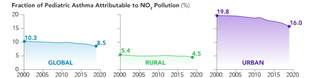
No Breathing Easy for City Dwellers: Nitrogen Dioxide
A new satellite-derived global dataset links concentrations of nitrogen dioxide with cases of pediatric asthma in urban areas around the world.go.nasa.gov
Air quality is an important contributor to disease. #NPHW
NASA-funded scientists linked health outcomes to satellite measurements of air pollutants like nitrogen dioxide and fine particulate matter (PM2.5). go.nasa.gov/3Kx5T5u
#NASAEarth
No Breathing Easy for City Dwellers: Nitrogen Dioxide
A new satellite-derived global dataset links concentrations of nitrogen dioxide with cases of pediatric asthma in urban areas around the world.go.nasa.gov
Small, inhalable particles called PM2.5 can contribute to diseases and premature death.
A @nasa-funded study found that 2.5 billion city dwellers worldwide live in areas where PM2.5 exceeds @WHO guidelines, leading to 1.8 million deaths in 2019. go.nasa.gov/3MeCSg6
#NASAEarth
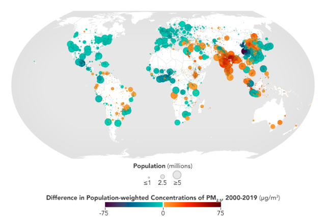
No Breathing Easy for City Dwellers: Particulates
A new satellite-derived dataset links concentrations of fine particulate matter in air pollution with health outcomes in cities around the world.go.nasa.gov
Wildfire smoke is one of the largest sources of unhealthy air quality.
To help extinguish its health effects, Jason Vargo of the @SFFED uses @nasa satellite data to better understand wildfire smoke impacts and build healthier communities.
Learn more: go.nasa.gov/3Zb93j2
#NASAEarth

Bright nighttime lights disrupt circadian rhythms and cause sleep deficiency.
Scientists compared @nasa nightlight and @cdc health data and found that poorer, non-white neighborhoods experience more artificial light at night. #NPHW go.nasa.gov/3nBnuQx
#NASAEarth
Brighter Neighborhoods Harm Human Health | NASA Applied Sciences
A newly emerging field of study is connecting the bright lights of U.S. cities at night to poorer human health.go.nasa.gov
#NASAEarth
Tracking Saharan Dust to Safeguard Public Health | NASA Applied Sciences
Formed from winds blowing loose sand, dirt, and debris, Saharan dust travels across the Atlantic Ocean and large quantities can result in poor air quality ango.nasa.gov
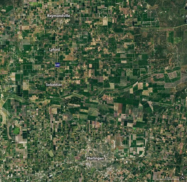
Farmers in the Rio Grande Valley are using @nasa satellite data to stop infestations of a cotton-loving beetle early in the growing season before they become severe and spread.
Full story: go.nasa.gov/3nF8scH
#NASAEarth
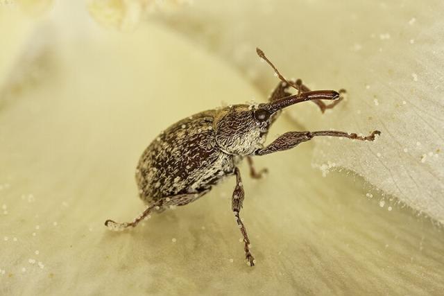
Battling Boll Weevils in Texas
Satellites are helping farmers in the Rio Grande Valley take on the cotton-loving beetles.go.nasa.gov
A winter storm in December 2022 dropped snow over Mauna Kea and the recently erupted Mauna Loa in Hawai’i.
An astronaut on the @Space_Station snapped this photo of the snowcapped volcanoes. go.nasa.gov/3TWwtIh 🌋❄️
#NASAEarth
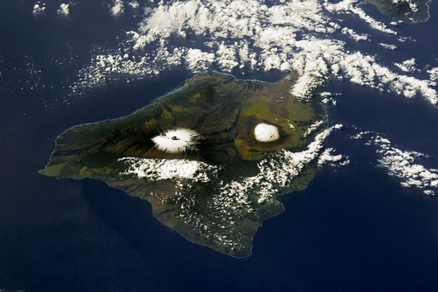
Lava and Snow in Hawai’i
A winter storm in December 2022 dropped snow over Mauna Kea and the recently erupted Mauna Loa.go.nasa.gov
Welcome to the Triassic parks!
This @nasa Terra satellite image shows the Ischigualasto and Talampaya parks in northern Argentina, an area that was teeming with crocodile- and mammal-like reptiles in the Triassic 252-200 million years ago. go.nasa.gov/40LPrnD
#NASAEarth
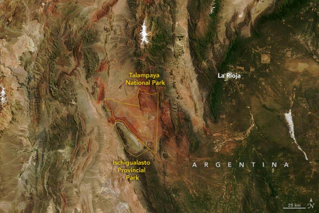
Triassic Parks
Fossils found in this region of Argentina have been key to understanding the origins and behaviors of mammals and dinosaurs.go.nasa.gov
Help us spruce up our banner image by voting for your favorite one:
#NASAEarth
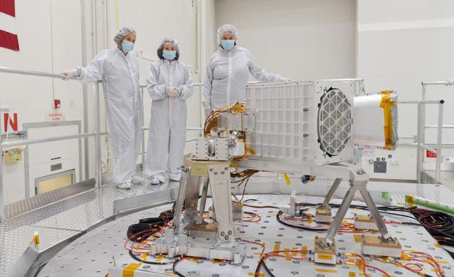
NASA is preparing to launch its TEMPO satellite next month!
TEMPO will observe air quality over North America from space every hour and reveal how pollution exposure varies by neighborhood and within a city. go.nasa.gov/3G3jjDq
#NASAEarth
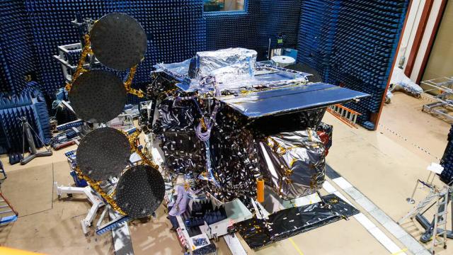
New Instrument to Track Pollution Hourly, Shed Light on Disparities
NASA is preparing for the launch of an instrument that will provide new insight into air quality in North America, observing air pollution from space more frequently and in greater detail than previous space-based instruments.Joe Atkinson (NASA)
#NASAEarth
Once in orbit, TEMPO will join a larger constellation of satellite missions that monitor air quality in Europe and Asia, @esa’s upcoming Sentinel-4 and South Korea’s GEMS, respectively.
Full story: go.nasa.gov/3G3jjDq
#NASAEarth
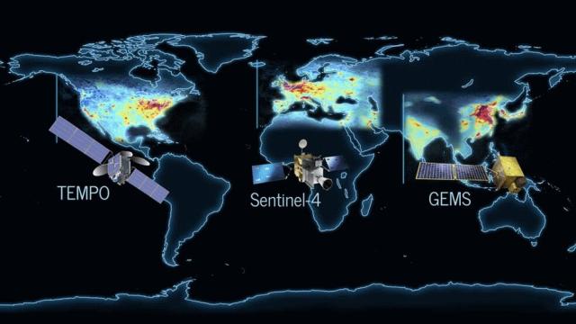
New Instrument to Track Pollution Hourly, Shed Light on Disparities
NASA is preparing for the launch of an instrument that will provide new insight into air quality in North America, observing air pollution from space more frequently and in greater detail than previous space-based instruments.Joe Atkinson (NASA)
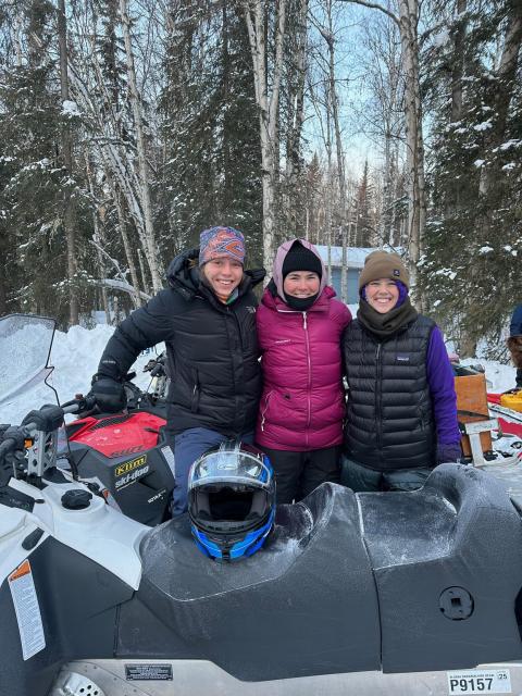
Elsa who? ❄️
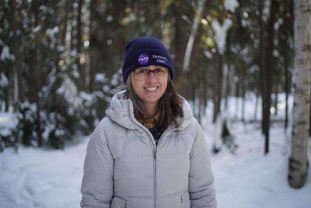
SnowEx was in the field this March – and it’s #WomensHistoryMonth!
Today, we’re celebrating the female scientists who showshoed and snowmobiled through Alaska, dug snow pits, and measured snow properties for @nasa’s SnowEx mission.
#NASAEarth
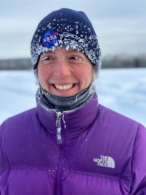
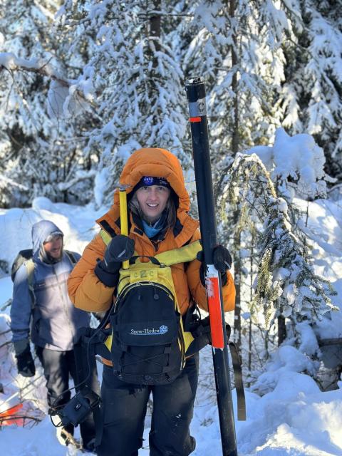
Carrie Vuyovich is a snow scientist @nasagoddard and the lead for NASA's SnowEx.
This year, Carrie is leading the largest SnowEx mission to date – with over 46 scientists helping to measure snow in the field and from research aircraft. ❄️ #WomenInScience
#NASAEarth
Spain’s fire season got off to an early start with an intense blaze in the eastern Castellon province. An astronaut on the @Space_Station took this photo on March 27, as a thick plume of smoke streamed southeast toward the Mediterranean Sea.
🔗 go.nasa.gov/3M4MlpX
#NASAEarth
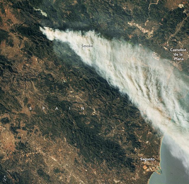
A Raging Fire in Spain
The 2023 fire season got off to an early start with a major fire in the Castellon province.go.nasa.gov
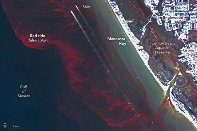
Scientists can now detect small-scale features of harmful algal blooms that occur close to beaches and inside small bays.
Using a data processing technique, they can view “red tide” events in false-color, seen in this Feb. 26 satellite image of Florida. go.nasa.gov/3nwk4ys
#NASAEarth

Putting the Red in “Red Tide”
Scientists developed a way to detect the fine-scale features of harmful algae blooms that occur close to beaches and inside small bays.go.nasa.gov
The work was done by scientists at the University of South Florida, using PlanetLabs satellite data made available through @nasaearthdata’s Commercial SmallSat Data Acquisition program.
Learn more: go.nasa.gov/40OoYoR
#NASAEarth
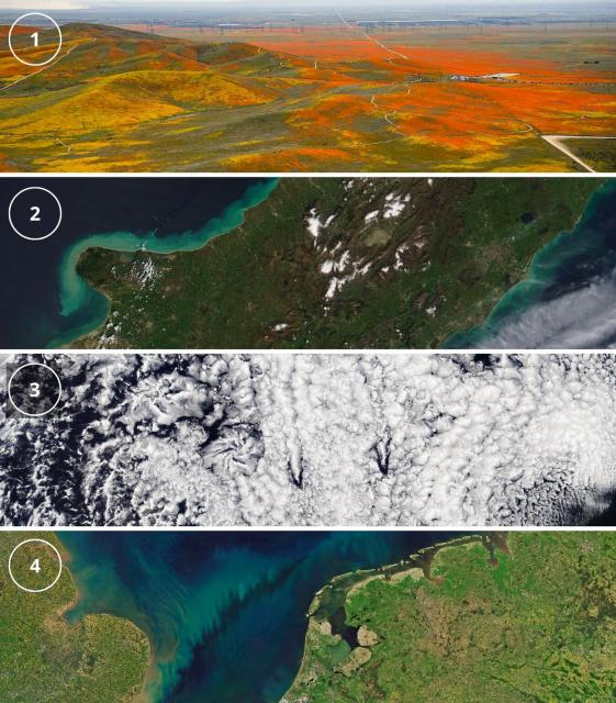
Ready for a puzzler?
Tell us where in the world this is, what we’re looking at, and why it’s interesting. go.nasa.gov/3Kk1N08 🧩 🌏
#NASAEarth
Earth Matters - March Puzzler
climate change, global climate change, global warming, natural hazards, Earth, environment, remote sensing, atmosphere, land processes, oceans, volcanoes, land cover, Earth science data, NASA, environmental processes, Blue Marble, global mapsgo.nasa.gov
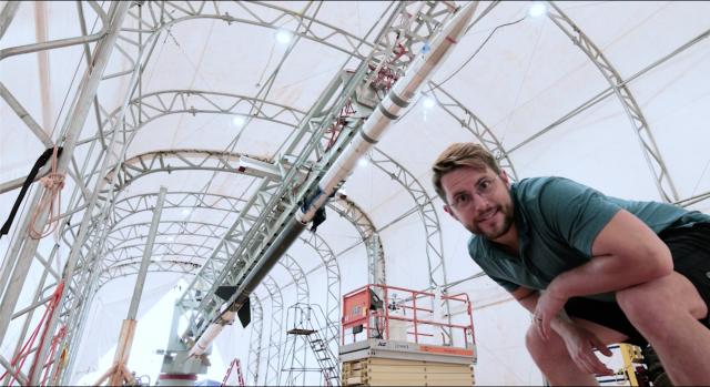
NASA experts travel far and wide on our home planet to learn more about the universe.
In this week’s episode of NASA’s Curious Universe podcast, @NASASun writer Miles Hatfield takes us to northern Australia for a sounding rocket launch. nasa.gov/curiousuniverse
#NASAEarth
NASA's Curious Universe
NASA.gov brings you the latest images, videos and news from America's space agency. Get the latest updates on NASA missions, watch NASA TV live, and learn about our quest to reveal the unknown and benefit all humankind.NASA
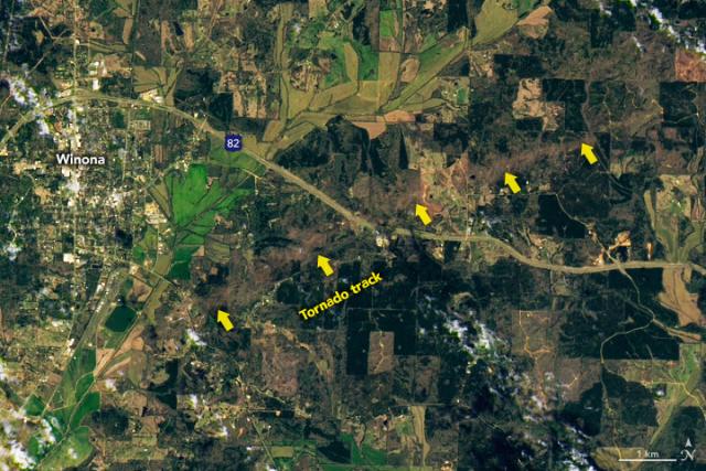
A tornado moved through Mississippi on March 24, leaving a 29-mile-long tornado track near the city of Winona.
The tornado’s path is visible in #Landsat satellite imagery captured the next day. go.nasa.gov/42Oq1He
#NASAEarth
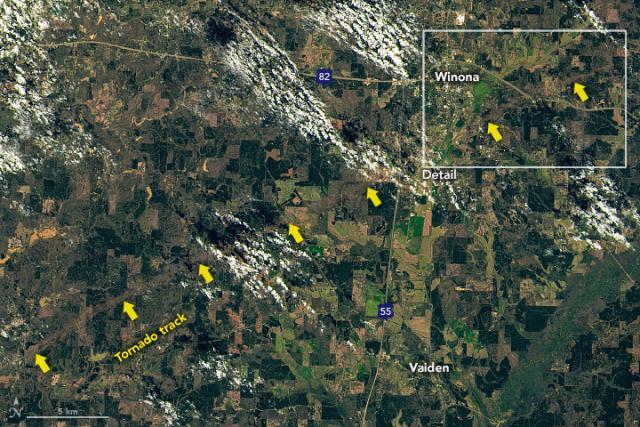
Tornado Leaves Path of Destruction in Mississippi
A deadly tornado left a 29-mile-long path near Winona, which is visible in satellite images.go.nasa.gov
We mourn the loss of Virginia T. Norwood, known as the “Mother of Landsat.” She designed the first space-based multispectral scanner that flew on the first #Landsat. Her impact lives on in how we see Earth from space.

Bidding Farewell to Virginia T. Norwood, the Mother of Landsat | Landsat Science
Virginia T. Norwood, a founding figure in the field of satellite land imaging, died on Sunday, March 26, 2023, at age 96.https://landsat.gsfc.nasa.gov/article/author/lrocchio/#author (Landsat Science)
From space, air, and on the ground, @nasa studies Earth and the ways it is changing. These observations help us better understand – and prepare for – the effects of human-caused climate change.
Today we released our 2023 climate strategy. go.nasa.gov/40rbT5a
#NASAEarth
NASA Releases Agency Climate Strategy
NASA has been working to better understand our home planet from the unique vantage point of space since the first TIROS satellites launched in the 1960s.Jamie Adkins (NASA)
NASA is developing technologies in space and on the ground that we can use to improve energy efficiency and storage, and mitigate the effects of climate change.
Read the full report: go.nasa.gov/40rbT5a
#NASAEarth
NASA Releases Agency Climate Strategy
NASA has been working to better understand our home planet from the unique vantage point of space since the first TIROS satellites launched in the 1960s.Jamie Adkins (NASA)
Scientists deployed Icefin, a remotely operated vehicle built for @NASAAstrobio research, to "swim" under two Antarctic glaciers and study them from below.
Bundle up and dive in! go.nasa.gov/3FZ4a6c 🧊🌊
#NASAEarth
SWOT’s that?
A first look at data from @nasa’s SWOT mission! 💧
This image shows sea level in two 75 mile wide strips in the Gulf Stream off the U.S. East Coast. Red indicates sea level higher than the global average; blue is lower. go.nasa.gov/3TOKaZu
#NASAEarth
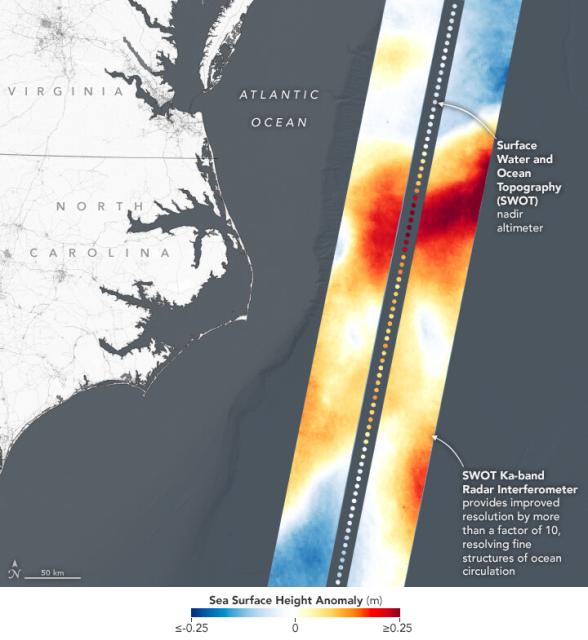
Water-Tracking Satellite Reveals First Views
The Surface Water and Ocean Topography mission has sent back some of its first glimpses of water on Earth’s surface, including a detailed view of the Gulf Stream.go.nasa.gov
Reminder: applications close tomorrow! 🚨⤵️ usajobs.gov/job/714177700
[Video embedded in original tweet]
#NASAEarth
")
Physical Scientist, AST - Science Technology Utilization and Commercialization (Direct Hire)
As a program area manager in the Applied Sciences Program of the Earth Science Division, you will lead the strategy, implementation, and oversight of eff orts to advance uses of Earth science information to inform decision making by public and privat…USAJOBS
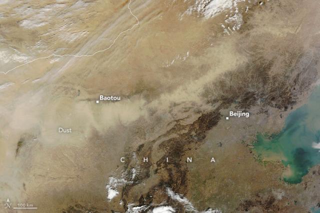
A low-pressure system lifted sand and dust from the Gobi Desert in late March, causing a major dust storm across Mongolia and China.
NASA’s Aqua satellite captured this image on March 22, 2023. go.nasa.gov/3nshw4g
#NASAEarth
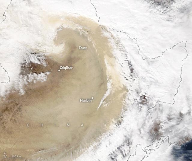
A Dusty Day in Northeastern China
A low-pressure system lifted sand and dust from the Gobi Desert and darkened skies in Beijing.go.nasa.gov
go.nasa.gov/3LWJorA
#NASAEarth
How Dust Affects the World’s Health
NASA research finds that a combination of windblown dust and human-caused particle pollution was associated with nearly 3 million premature deaths in 2019.go.nasa.gov
Depending on the size and type of particles and where they reach in the atmosphere, dust can contribute to warming or cooling, and influence storms and weather events.
NASA’s EMIT instrument is now on the @Space_Station, mapping dust around the globe. go.nasa.gov/3nnHpST
#NASAEarth
Home – EMIT
EMIT will make the first detailed maps of dust composition of Earth’s dust source regions and use state-of-the-art climate models to better understand regional and global heating and cooling impacts and future changes in dust source regions.EMIT