Search
Items tagged with: mapping
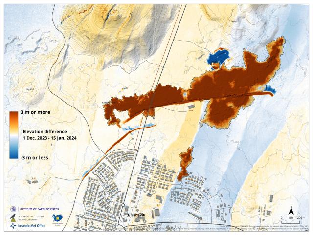
Elevation difference map (vertical displacement) based on two different acquisitions by our remote sensing team. These area base on two DEMs spanning 1 Dec. to 15 Jan. covering the latest eruption in #Grindavík
Reds:
- New lava fields
- Lava barriers
Blues:
- Quarry for barriers
- Barrier entrenchment
- Graben formation
DWeb New York May 2023
About this event
Come hang out with folks associated with DWeb principles in New York City. This month we're being hosted at Blackbird Infoshop in Kingston, NY.
We will have a presentation on peer-to-peer technology and mapping by Mauve (github) followed by a hike in the Hudson River Valley.
Mauve is an Occult Enby that's making local-first software with peer to peer protocols, mesh networks, and the web.
Mapping has long been a tool of coercion and control, let's take back our geography!
(We will stream the non-hike portion via https://chat.celehner.com/group/cchat)
How to get to Kingston via mass transit
Via Trailways bus from NYC port authority: trailways.com/schedules/bus-fr…
Via MetroNorth from NYC's Grand Central Station
From either of these locations, you will need a lift to Blackbird. Please contact the coordinators. There are rides available.
#NationalParks #Travel #Mapping

