Search
Items tagged with: nasaearth


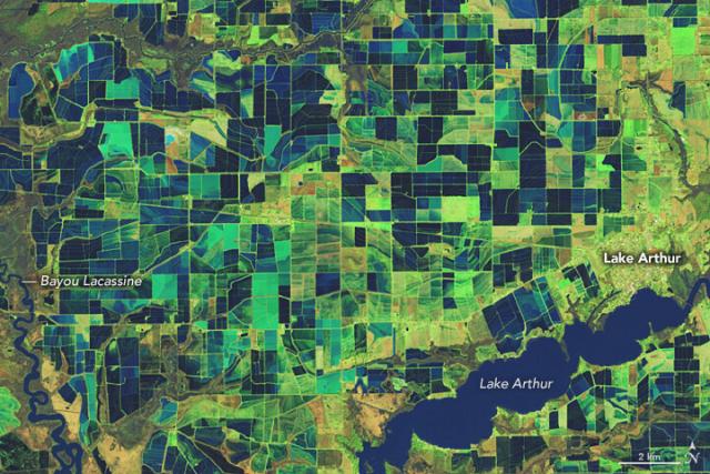
The Mississippi River Valley is home to most of the rice farms in the United States. 🌾🍚
This #Landsat 9 image shows the patchwork of flooded rice fields in southwestern Louisiana on February 3, 2023. go.nasa.gov/3LmwPFw
#NASAEarth
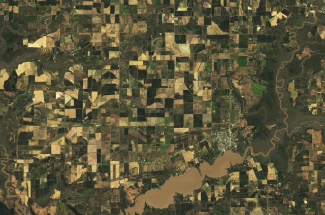
Louisiana is the nation’s third-largest producer of rice, after Arkansas and California.
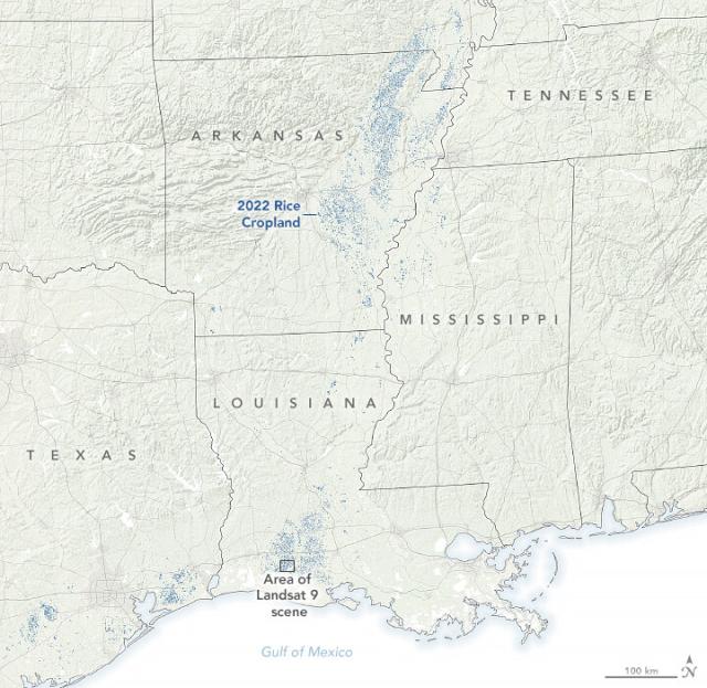
In 2021, the Rice Belt (Arkansas, Louisiana, Mississippi, and Texas) produced about 73%of all rice in the U.S. The map here shows rice-growing areas within these states (in blue) in 2022.
#NASAEarth
Our view from space can also show us how crops like rice are growing.
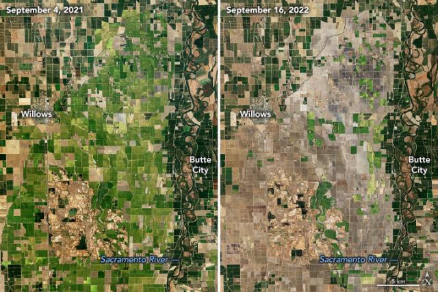
Satellites like #Landsat and Terra helped map a drop in rice acreage during a drought in Sacramento’s Central Valley – normally the largest rice-growing region in California.
🔗earthobservatory.nasa.gov/imag…
#NASAEarth
A new air pollution mission, called MAIA, will investigate the health impacts of tiny airborne particles polluting some of the world’s most populated cities.
@nasa and @ASI_spazio are partnering to build and launch MAIA before the end of 2024.
Details: go.nasa.gov/3YFdQJo
#NASAEarth
NASA and Italian Space Agency Join Forces on Air Pollution Mission
The two agencies are partnering on a satellite to understand the effects of different types of particle pollution on human health.NASA Jet Propulsion Laboratory (JPL)
When you think of NASA, do you think of...
Rockets or corn?
Space or wheat?
Mars or rice?
NASA data also plays a big role in the food we eat, from water management to sustainable farming processes.
#NASAEarth
When you think of NASA, do you think of...
Rockets or corn?
Space or wheat?
Mars or rice?
NASA data also plays a big role in the food we eat, from water management to sustainable farming processes.
#NASAEarth
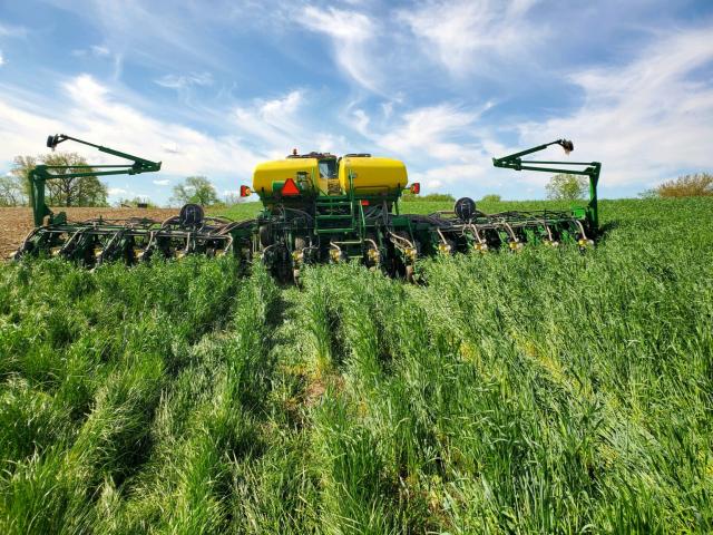
The Corn Belt in the midwest is home to the nation’s most productive soils.
Hundreds of miles above, NASA satellites provide critical views of the region that help scientists study soil loss over time and develop tools for conservation techniques.
🔗 go.nasa.gov/3mDlpD9
#NASAEarth
Shoring up the Corn Belt’s Soil Health With NASA Data
Soil is the foundation of our food systems, and sustainable farming depends upon healthy soil, which has impacts far beyond the field on air, water and climate.Lina Tran (NASA)
🔗go.nasa.gov/3ZLbJVw
#NASAEarth
NASA Engages U.S. Farmers: Bringing Satellite Data Down to Earth
NASA is increasing its decades-long investment in U.S. agriculture through the launch of NASA Acres, a new consortium that will unite physical, social, and economic scientists with leaders in agriculture from public and private sectorsAries Keck (NASA)
Tropical Cyclone Freddy, an unusually long-lived storm, wandered in the Indian Ocean for more than a month, bringing strong winds and downpours to anything in its path.
The @NOAA-20 satellite captured this image of the storm on March 8, 2023. go.nasa.gov/3YDQP9I 🌀
#NASAEarth
For the Longest Time
Tropical Cyclone Freddy, an unusually long-lived storm, wandered in the Indian Ocean for more than a month.go.nasa.gov

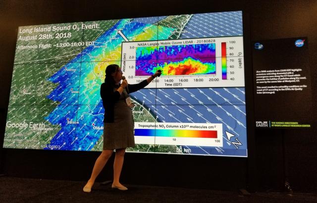
Many @nasaearth satellites use light to study Earth from space.
Light from the Sun bounces off Earth and to the satellite’s sensor. Each wavelength of light tells scientists something about the surface below. Julia and her team make sure those sensors are extremely precise.
#NASAEarth
Julia Barsi also works with the @NASA_Goddard GLAMR lab, where scientists test sensors before the satellite is sent to space.
They shine laser light at the sensor to see how it responds to different wavelengths. This information helps scientists interpret the satellite data.
#NASAEarth

Julia Barsi is one of the many #WomenInScience at NASA who help us learn more about our home planet.
Follow along this #WomensHistoryMonth as we highlight more female-identifying scientists at NASA.
#NASAEarth
Happy #InternationalWomensDay!
From studying air quality to sea ice, women at @nasa help us learn more about our home planet. 🌎👩🔬#IWD2023
Follow along this #WomensHistoryMonth as we highlight more female-identifying scientists at NASA.
#NASAEarth

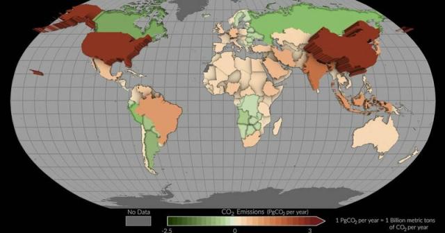
NASA’s OCO-2 satellite helps track carbon dioxide emissions for more than 100 countries.
In this map, countries where more carbon dioxide was removed than emitted appear as green depressions, while countries with higher emissions are tan or red and appear to pop off the page.
#NASAEarth
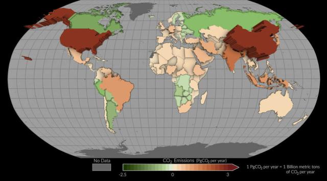
“NASA is focused on delivering Earth science data that addresses real world climate challenges – like helping governments around the world measure the impact of their carbon mitigation efforts.” – Karen St. Germain, NASA’s Earth Science Division director
NASA Mission Takes Stock of Carbon Dioxide Emissions by Countries
A pilot project has estimated emissions and removals of carbon dioxide in individual nations using satellite measurements.Tony Greicius (NASA)
Every day, @nasa data gets served on a dinner plate. 🍽️
Our fleet of Earth-observing satellites helps farmers make critical decisions about how to better grow food on our changing planet.
Inside Agriculture | NASA Applied Sciences
Our mission is to bring the wealth of scientific experience and understanding of Earth observations to the challenges of a hungry world.go.nasa.gov
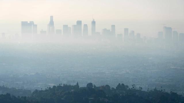
Scientists mapped nitrogen dioxide (NO2) in California’s air at the neighborhood scale and found hotspots of the air pollutant near high-rise buildings and food processing facilities.
Dark orange shows where NO2 concentrations were highest in 2018 & 2019. go.nasa.gov/3Jgjs8x
#NASAEarth
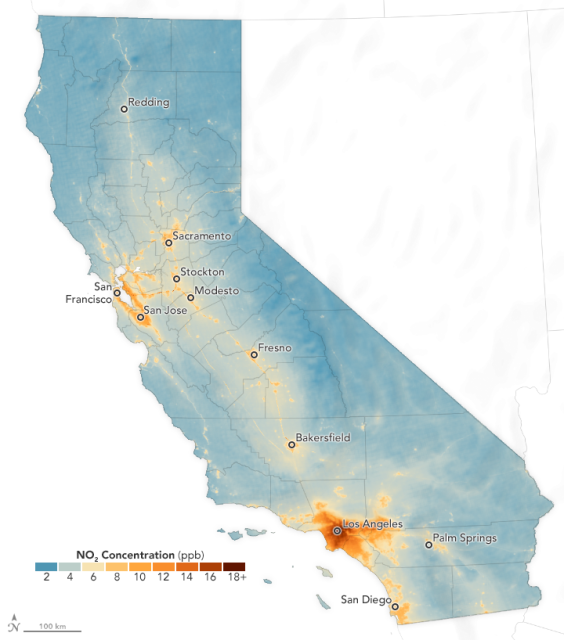
Nitrogen Dioxide in the Neighborhood
A team of scientists mapped nitrogen dioxide in California’s air at the neighborhood scale and found hotspots of the air pollutant near high-rise buildings and food processing facilities.go.nasa.gov
TEMPO, an upcoming @nasa mission, will allow scientists to see how concentrations of pollution—such as NO2 and ozone—change over time depending on temperature, wind, traffic patterns, and other phenomena.
Learn about TEMPO:
go.nasa.gov/424mg07
#NASAEarth
After torrential rains in São Paulo, a state in southeast Brazil, #Landsat images revealed widespread landslides in the coastal São Sebastião municipality.
This Feb. 26 image shows landslides across the hilly landscape between Jaqueí and Praia da Baleia. go.nasa.gov/3EVK3VZ
#NASAEarth

Landslides in São Paulo, Brazil
After torrential rains, satellite images revealed widespread landslides in the Brazilian state’s coastal municipality of São Sebastião.go.nasa.gov
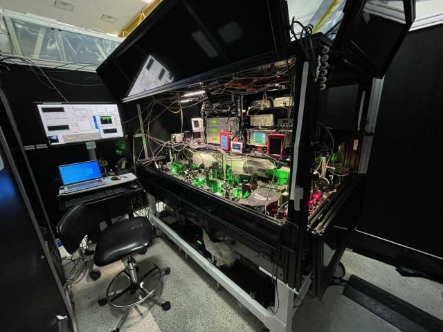
Quantum science is behind many technologies we use on Earth and helps us study the universe's biggest mysteries.
Learn more alongside Ant-Man actor Paul Rudd! 🐜👇
#NASAEarth
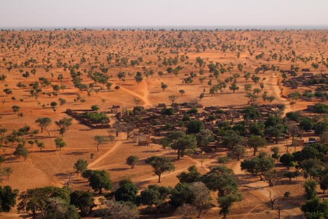
An astronaut aboard the @Space_Station captured this panoramic view of the Kalahari Desert in southern Africa. 🧑🚀📷🌍
The dark-toned lines of forest in Botswana’s Okavango inland delta are prominent against the tan landscape. go.nasa.gov/3KMgmKR
#NASAEarth
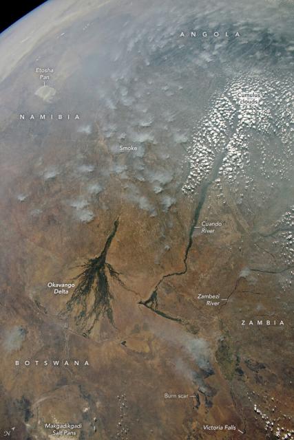
Northern Kalahari Desert Panorama
Smoke and cumulus clouds dotted the sky when an astronaut photographed a remote part of Botswana, Zambia, Namibia, and Angola.go.nasa.gov
Over the Cuando River basin (upper right corner in this image) a cloud free line traces the course of a river.
This line reflects a zone of cooler air directly above the river where cloud development is suppressed—at least on days with little wind.
#NASAEarth

#NASAEarth
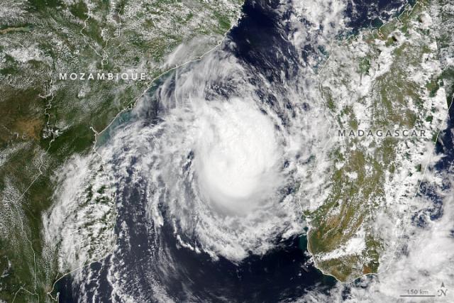
Tropical Cyclone Freddy brought heavy rain and flooding to Madagascar and Mozambique. This animation shows NASA IMERG satellite precipitation estimates from Feb. 6 to March 2, along with the cyclone’s position and intensity.
Details:
go.nasa.gov/3Yl5SVF
#NASAEarth
Tropical Cyclone Freddy Brings Heavy Rain and Flooding to Madagascar and Mozambique | NASA Global Precipitation Measurement Mission
Tropical Cyclone Freddy first made landfall along the east coast of Madagascar just north of the town of Mananjary on Feb.go.nasa.gov
📢UPDATE: EMIT’s data is now available to the public through the open science portal: VISIONS. You can explore what measurements have been made and where the mission will be observing next.
Get started: earth.jpl.nasa.gov/emit/data/d…
[Video embedded in original tweet]
#NASAEarth
Coverage and Forecasts | EMIT Open Data Portal – EMIT
EMIT will make the first detailed maps of dust composition of Earth’s dust source regions and use state-of-the-art climate models to better understand regional and global heating and cooling impacts and future changes in dust source regions.EMIT
Overgrazing by deer poses a threat to a giant quaking aspen tree colony in Utah that scientists have named Pando.
In this image by #Landsat 9, Pando’s yellow leaves are visible for about 200 meters on either side of State Route 25. go.nasa.gov/3KPIeNU
#NASAEarth
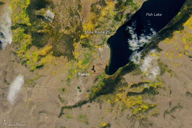
Saving a Forest of One
Overgrazing by deer poses a threat to a giant quaking aspen tree colony in Utah—one of the largest organisms in the world.go.nasa.gov
The dust storm is visible in this simulated natural-color image, acquired late in the afternoon on February 26 by GOES-16, operated by @noaa. @nasa helps develop and launch the GOES satellites.
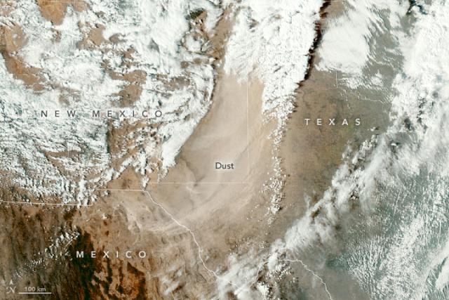
Dust Blows Across the U.S. Southwest
In the wake of a cold front, strong winds lofted dust into the air over northern Mexico, eastern New Mexico, and northwestern Texas.go.nasa.gov
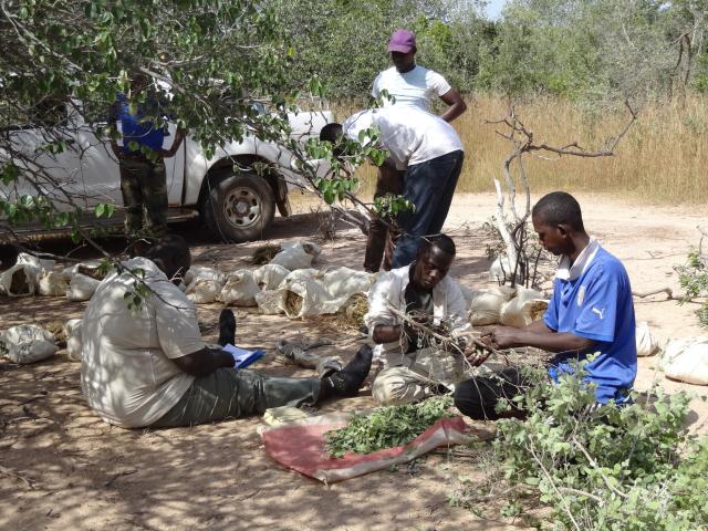
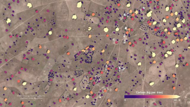
An international team including @nasa scientists mapped nearly 10 billion individual trees in Africa’s drylands. 🌳
Their goal? Assess the amount of carbon stored outside of Africa’s tropical forests, which is essential for climate change projections. go.nasa.gov/3ZzUg2l
#NASAEarth
Counting Carbon Stored in African Dryland Trees
With the help of artificial intelligence and high-resolution satellite images, scientists mapped almost 10 billion individual trees in Africa’s drylands to assess the amount of carbon stored outside of the continent’s dense tropical forests.Rob Garner (NASA)
#NASAEarth
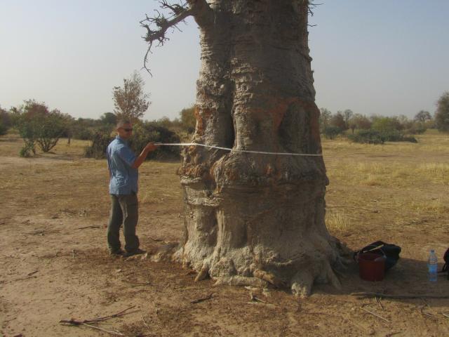
The team found there are far more trees in semi-arid regions of Africa than previously thought. But those trees store less carbon than some models predicted.
They estimate roughly 0.84 petagrams of carbon are locked up in African drylands.
(1 Pg = 1 billion metric tons)
#NASAEarth
The data are publicly available with a viewer app developed by the team. #OpenScience
The app identifies individual trees in satellite imagery and shows the amount of carbon they contain.
Full story: go.nasa.gov/3ZzUg2l
#NASAEarth
Counting Carbon Stored in African Dryland Trees
With the help of artificial intelligence and high-resolution satellite images, scientists mapped almost 10 billion individual trees in Africa’s drylands to assess the amount of carbon stored outside of the continent’s dense tropical forests.Rob Garner (NASA)
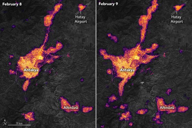
Strong earthquakes in Türkiye on Feb. 6 left many areas without electric power.
These maps show light around Antakya before (left) and after the earthquakes (right). Maps are from the Black Marble HD product, using @nasa @noaa Suomi-NPP satellite data. go.nasa.gov/3xTvQVw
#NASAEarth
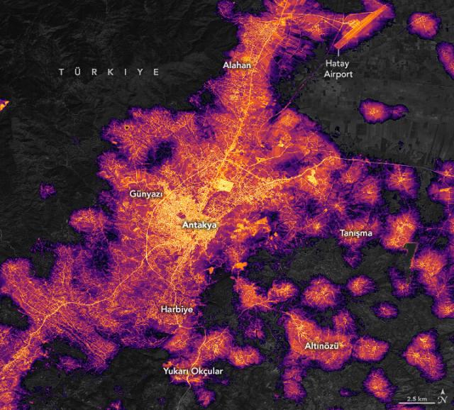
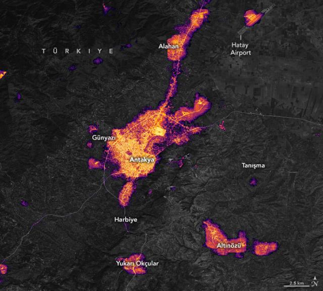
Dark Nights in Antakya
In the days after strong earthquakes struck Türkiye, significant destruction left many areas without electric power.go.nasa.gov
#NASAEarth
An astronaut on the @Space_Station took this photo of Mōkapu Peninsula.
The U.S. Marine Corps Base Hawaii spans most of the peninsula. Next to it is a tuff ring crater called Ulupa’u Head that belongs to the lower part of the Honolulu volcanic series.
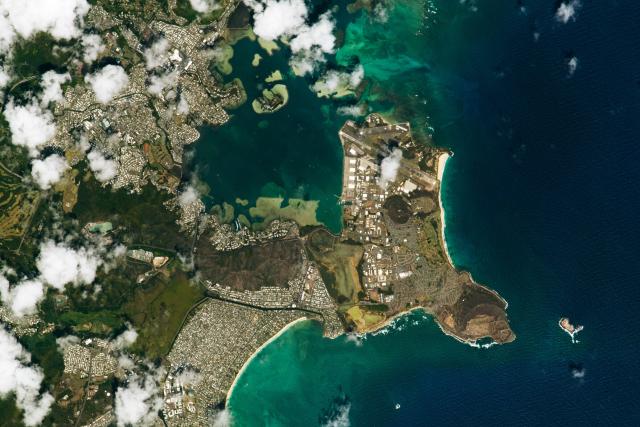
Mōkapu Peninsula
The east coast of O’ahu, Hawaii, displays an array of natural and human-made features.go.nasa.gov
“I realize that following my curiosity opened me up to a world I never thought I would be in — a world beyond who I thought I could be or what I thought I could do."
Dr. Justin Rice helps make Earth science data accessible to a worldwide community.
#NASAEarth

#NASAEarth

Data Chat: Dr. Justin L. Rice
Data Chat with Justin L. Rice, NASA’s Deputy Manager for the ESDIS Project’s Science Systems Development OfficeJoseph Smith (Earthdata)
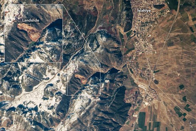
On February 14, 2023, an astronaut aboard the @Space_Station photographed a landslide in a canyon near İslahiye in southeastern Türkiye.
İslahiye is one of several towns and cities where large numbers of homes were damaged or destroyed by the earthquakes.
#NASAEarth