Search
Items tagged with: landsat
Severe thunderstorms tore through the U.S. Midwest and Mid-South where they spawned dozens of tornadoes across seven states. https://go.nasa.gov/3MlnoHf
#NASAEarth

Tornado Razes a Path Through Wynne
A path of destruction across the Arkansas town is visible to Landsat after another tornado outbreak swept across parts the U.S.go.nasa.gov

The tornado’s path is visible in #Landsat satellite imagery captured the next day. https://go.nasa.gov/42Oq1He
#NASAEarth
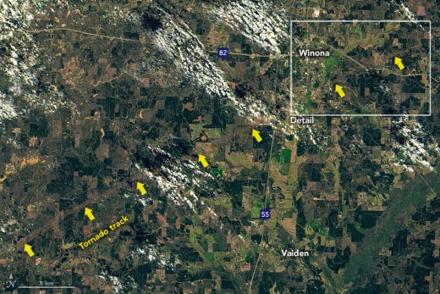
Tornado Leaves Path of Destruction in Mississippi
A deadly tornado left a 29-mile-long path near Winona, which is visible in satellite images.go.nasa.gov
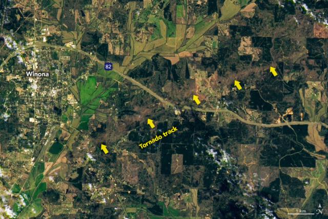
https://go.nasa.gov/3nxkDrR
#NASAEarth

Bidding Farewell to Virginia T. Norwood, the Mother of Landsat | Landsat Science
Virginia T. Norwood, a founding figure in the field of satellite land imaging, died on Sunday, March 26, 2023, at age 96.https://landsat.gsfc.nasa.gov/article/author/lrocchio/#author (Landsat Science)
#NASAEarth
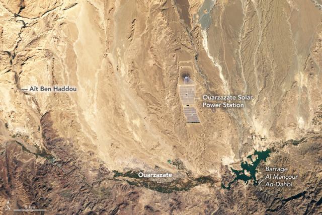
Sunny Days in Morocco’s Ouarzazate Basin
The dry, sunny basin is the site of a solar power station that supplies electricity to nearly 2 million Moroccans.go.nasa.gov
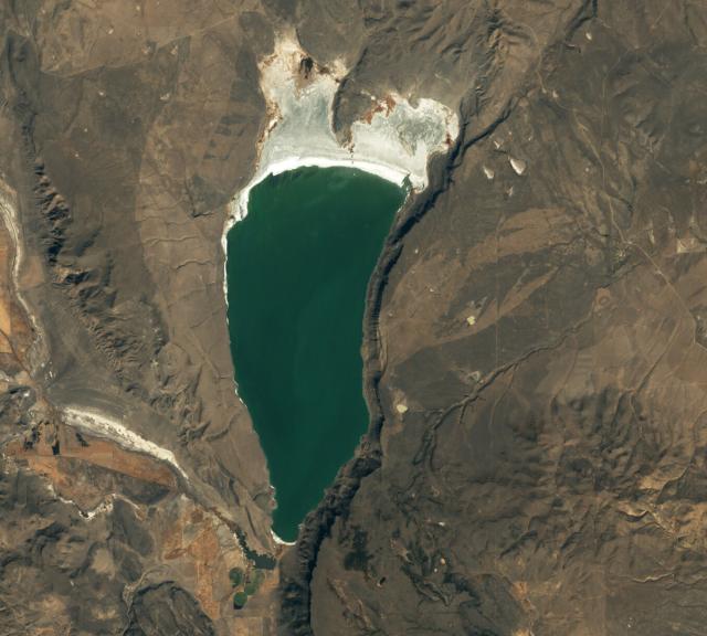
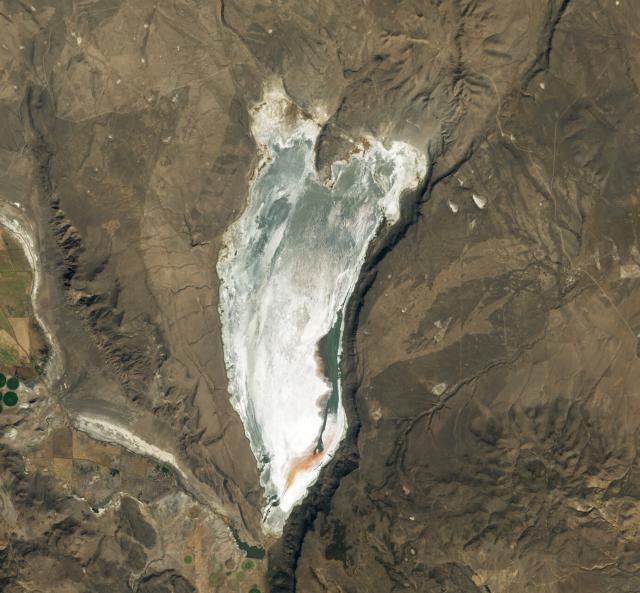
#Landsat 8 captured these images before the canal widened (left) in 2019 and after in 2023 (right).
Full story: https://go.nasa.gov/3nc1rzI
#NASAEarth
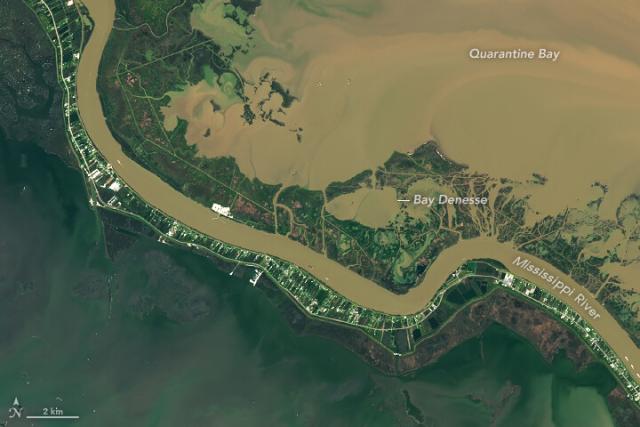
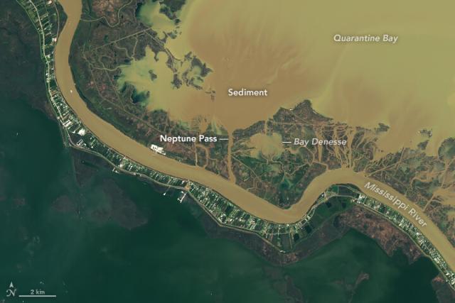
The Widening of Neptune Pass
The pass now has a flow five times that of New York’s Hudson River.go.nasa.gov
#Landsat 8 captured this image of Potosí and the nearby mountain, Cerro Rico, on November 24, 2022.
https://go.nasa.gov/3FwpQq2
#NASAEarth
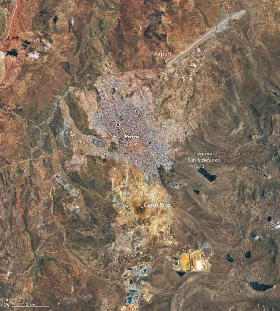
Potosí and Cerro Rico
The Bolivian mining city—one of the highest cities in the world—grew at the foot of an eroded volcano riddled with silver.go.nasa.gov
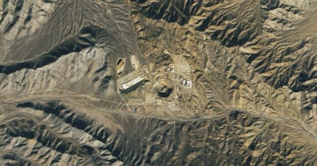
#Landsat 8 captured this image of the Mountain Pass Mine, with an open-pit area that extends 800 meters (2,600 feet) across and more than 180 meters (590 feet) deep. https://go.nasa.gov/3FqrY2o
#NASAEarth
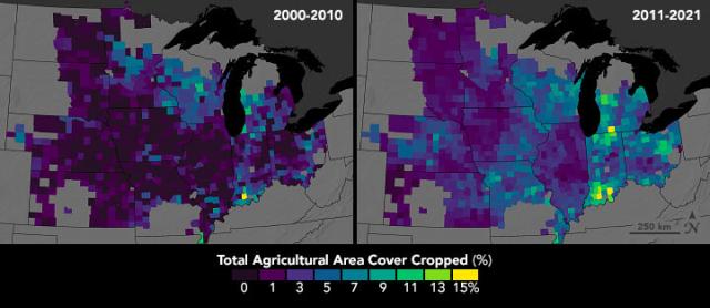
The #Landsat mission observes crops from space, helping farmers make decisions about how to better grow food. In this data sonification, see and hear how crops in the U.S. have changed over 20 years.
How #Landsat data is used: https://go.nasa.gov/3T5z6GZ
#NASAEarth
From Space to Farm
Farmers rely on the accuracy of a crucial NASA and USGS mission, Landsat, to make decisions about crops. Those decisions have far-reaching implications that can impact what you see on your dinner plate!Sarah Loff (NASA)
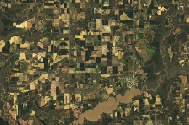
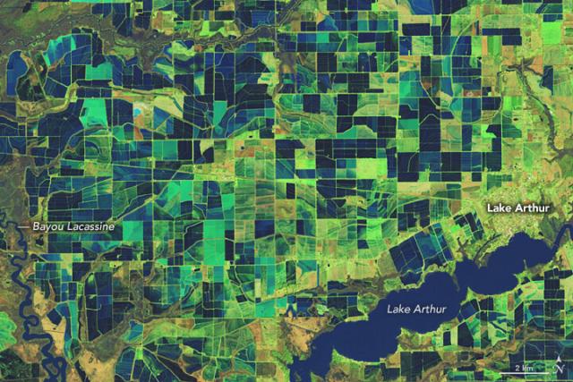
This #Landsat 9 image shows the patchwork of flooded rice fields in southwestern Louisiana on February 3, 2023. https://go.nasa.gov/3LmwPFw
#NASAEarth
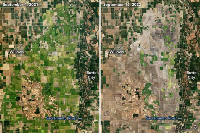
Satellites like #Landsat and Terra helped map a drop in rice acreage during a drought in Sacramento’s Central Valley – normally the largest rice-growing region in California.
🔗https://earthobservatory.nasa.gov/images/150412/a-rough-year-for-rice-in-california
#NASAEarth
This Feb. 26 image shows landslides across the hilly landscape between Jaqueí and Praia da Baleia. https://go.nasa.gov/3EVK3VZ
#NASAEarth

Landslides in São Paulo, Brazil
After torrential rains, satellite images revealed widespread landslides in the Brazilian state’s coastal municipality of São Sebastião.go.nasa.gov
In this image by #Landsat 9, Pando’s yellow leaves are visible for about 200 meters on either side of State Route 25. https://go.nasa.gov/3KPIeNU
#NASAEarth
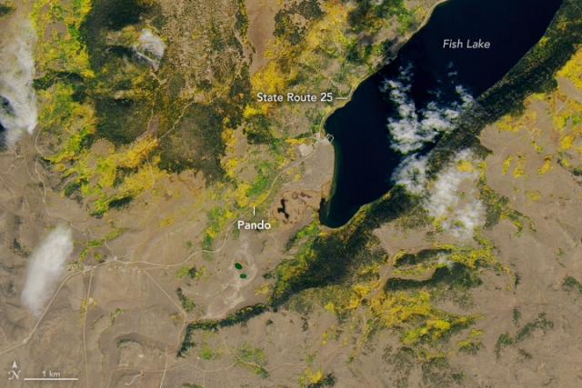
Saving a Forest of One
Overgrazing by deer poses a threat to a giant quaking aspen tree colony in Utah—one of the largest organisms in the world.go.nasa.gov
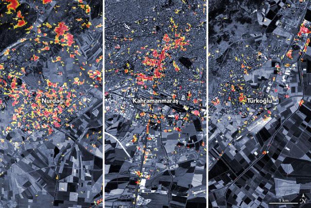
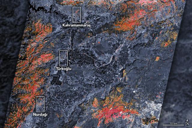
This #Landsat 9 image shows small landslides along a valley east of Sarıseki, Türkiye, on Feb. 14. https://go.nasa.gov/3IROLGI
#NASAEarth
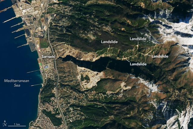
Landslides in Türkiye
Scientists are using satellite images to locate landslides following the powerful earthquakes that struck in early February.go.nasa.gov
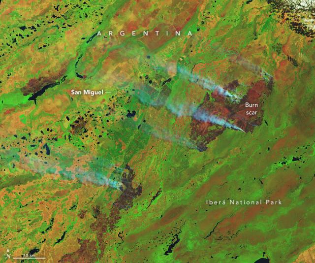
The fires began in late December 2022 and were still ablaze when #Landsat 9 took these images on Feb. 19, 2023. https://go.nasa.gov/41efMuW
#NASAEarth
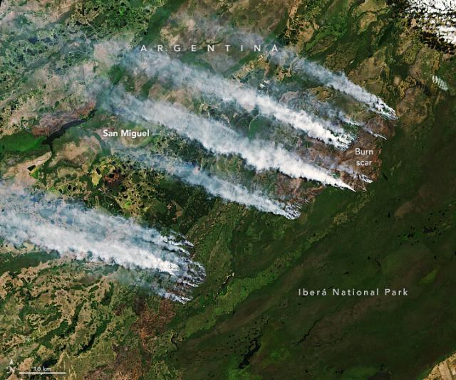
Fires Burn in Argentina’s Iberá National Park
Fueled by a heatwave and prolonged drought, fires burned the protected Argentine oasis, home to capybaras and jaguars.go.nasa.gov
During Mardi Gras season in 2012, the Mississippi River broke through its eastern bank and created a new channel to the Gulf of Mexico, the Mardi Gras Pass. #Landsat 8 recently captured this image of the pass.
Learn more: https://go.nasa.gov/41km8t0
#NASAEarth
Mardi Gras Pass
This free-flowing distributary reconnects the mighty Mississippi to the wetlands of Louisiana.go.nasa.gov
#Landsat took this photo of State Farm Stadium in Glendale, AZ.
And in 2020, NASA's ICESat-2 satellite measured the relative elevation of the stadium, which stands over 200 feet tall! https://go.nasa.gov/3JZLaak
#NASAEarth
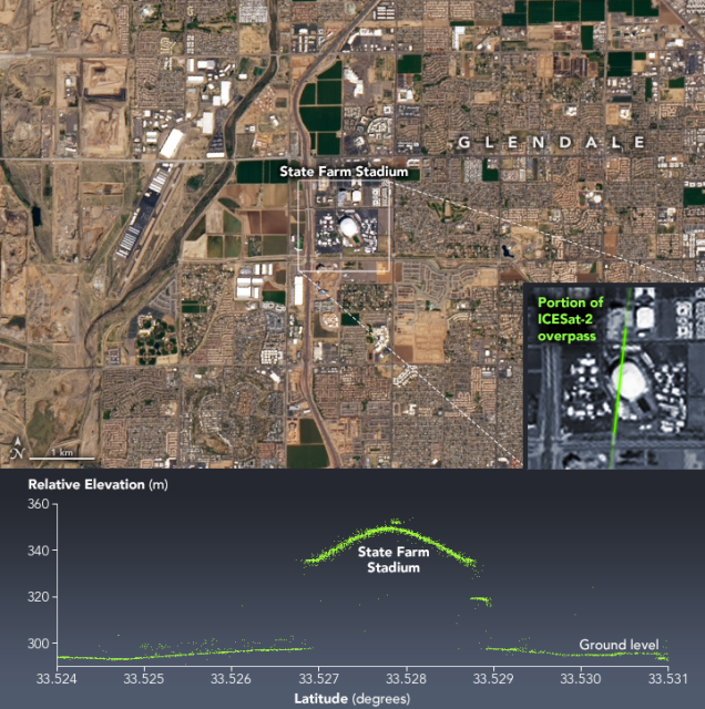
A Super View of Arizona
State Farm Stadium, the site of Super Bowl LVII, stands out from the surrounding desert landscape when viewed from above.go.nasa.gov
The #Landsat 9 images show a snow-covered desert landscape and sand dunes near the Keriya River in the Xinjiang region of western China, taken after a powerful winter storm earlier this month. ❄️https://go.nasa.gov/3JvzlZu
#NASAEarth
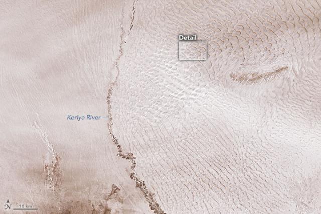
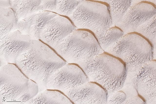
Wintry Dunes on Earth and Mars
Dunes on both planets occasionally get blanketed with ice and snow—except on Earth the white stuff is frozen water and on Mars it’s often frozen carbon dioxide.go.nasa.gov
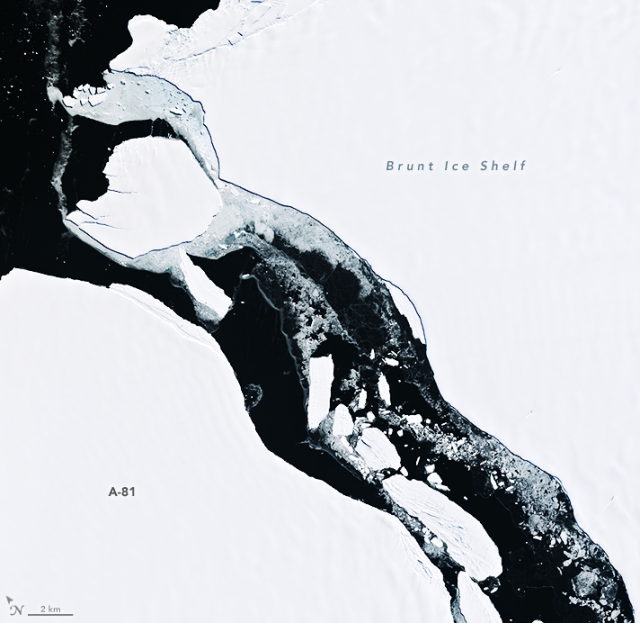
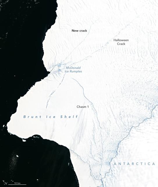
This #Landsat image from Jan. 25 shows the A-81 berg on the left and the new front of the Brunt Ice Shelf on the right.
According to a @NASAGoddard glaciologist, satellite images show the front has retreated 20 km since 1973. http://go.nasa.gov/1333
#NASAEarth

Nevada’s Clayton Valley, the site of the only active lithium mine in the United States, is shown in this #Landsat 9 image captured on December 8, 2022.
⛏️: https://go.nasa.gov/3ke4eXx
#NASAEarth
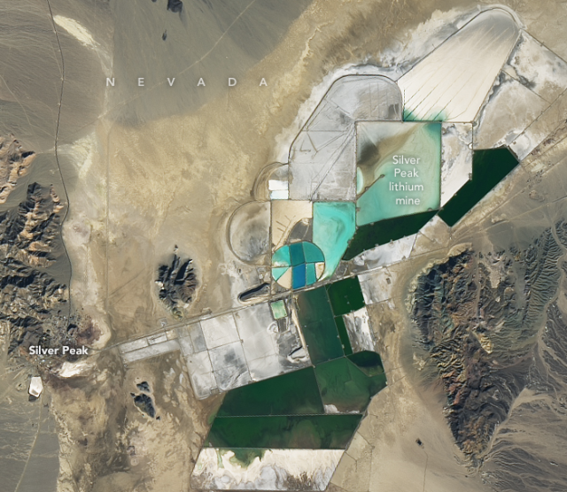
Racing to Mine Lithium
One way of harvesting the valuable metal involves the use of evaporation ponds that concentrate the substance into lithium-rich brines.go.nasa.gov
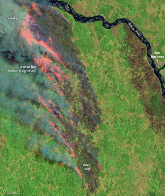
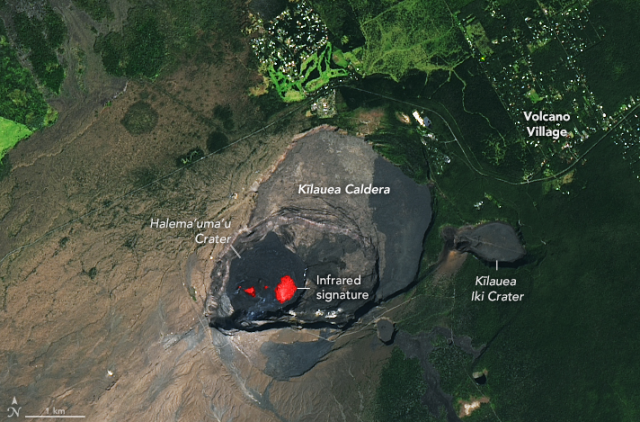
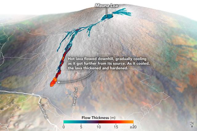
This image made from #Landsat 8 data shows a satellite view of the volcano from Jan. 11 overlaid with the infrared signature (in red) from the lava’s heat.
🌋: https://go.nasa.gov/3IRSVhZ
#NASAEarth
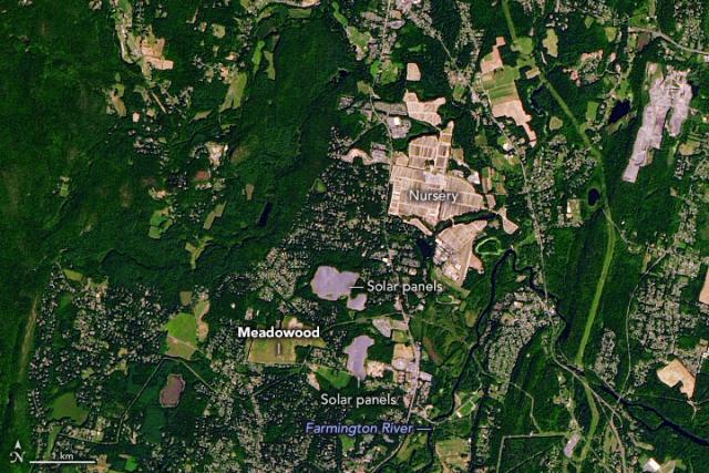
This #Landsat 9 image shows the Meadowood tobacco farm, where King worked, in Simsbury, CT. https://go.nasa.gov/3X8BbmJ
#NASAEarth
@nasa’s #Landsat 8 satellite captured these images on Jan. 3, 2023. Activity started in August 2022 has continued periodically. https://go.nasa.gov/3GFjh4i
#NASAEarth
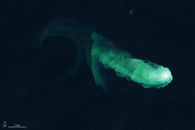
Kaitoku Says Hello
Swirls of discolored water are signs of activity from the underwater volcano.go.nasa.gov
#NASAEarth
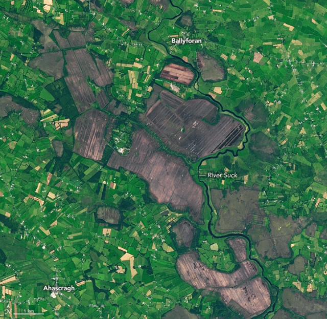
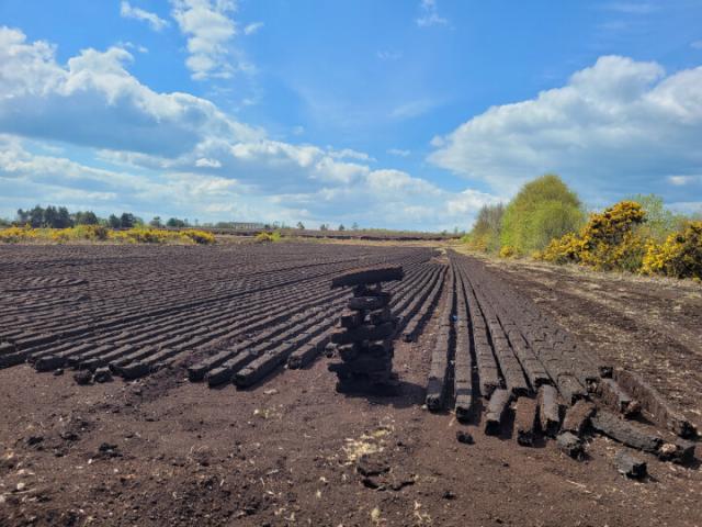
Ireland’s Cutaway Peatlands
Peatlands have been mined in Ireland for centuries, but concern for climate is changing how they are managed.go.nasa.gov
For half a decade, the mission has collected data on Earth’s forests, farms, urban areas, and freshwater, generating the longest continuous record of its kind.https://go.nasa.gov/3C6Tv7j
#NASAEarth
🌋 https://go.nasa.gov/3j6wdYV
#NASAEarth
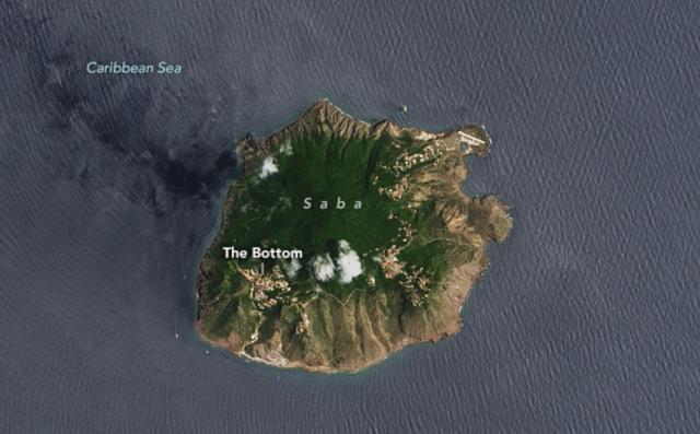
Saba Island
The quiet Caribbean island has been a destination for divers looking to spot corals and sea urchins.go.nasa.gov