Search
Items tagged with: nasaearth
Laguna Verde sure looks blue from the @Space_Station!
@NASA_Astronauts Woody Hoburg took this photo of Laguna Verde, a high-altitude salt lake in the Andes mountains of Chile, on July 7, 2023.
See more ISS views: https://go.nasa.gov/454MjEK 🧑🚀📷
#NASAEarth

Earth
Photographs of Earth taken by astronauts aboard the International Space Station.NASA Johnson (Flickr)

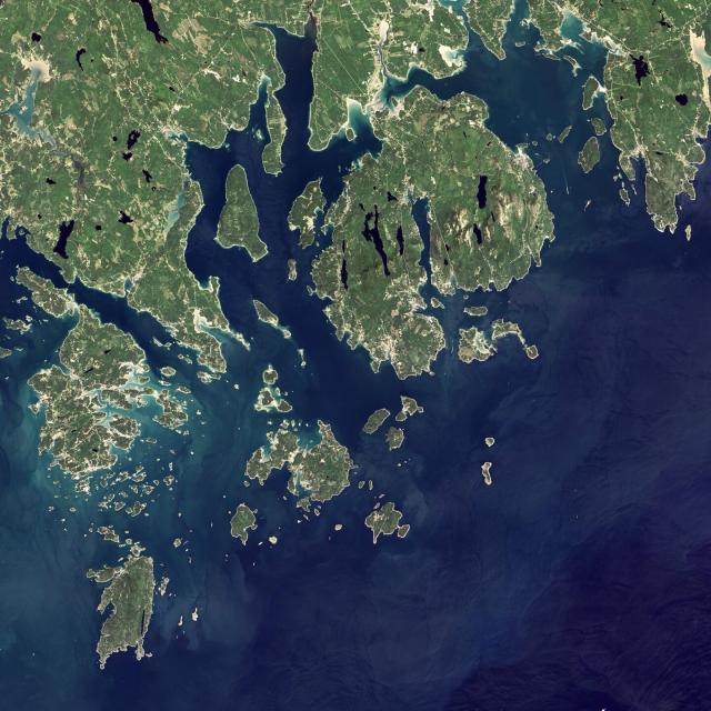
Time for a trip 🏝️
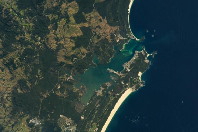
A @Space_Station astronaut took this photo of Port Stephens Bay, 160 kilometers (100 miles) north of Sydney, Australia. Towns, beaches, bays, and forests are visible along this stretch of the southeast Australian coast. https://go.nasa.gov/3Dv8fNS
#NASAEarth
The data from STAQS will complement new measurements from NASA’s TEMPO satellite, which measures hourly daytime air pollution over North America.
TEMPO launched in April 2023. 🛰️ https://go.nasa.gov/45586w6
#NASAEarth
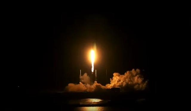
NASA’s High-Resolution Air Quality Control Instrument Launches
A NASA instrument to provide unprecedented resolution of monitoring major air pollutants – down to four square miles – lifted off on its way to geostationary orbit at 12:30 a.m. EDT Friday.Abbey Donaldson (NASA)
#NASAEarth

NASA-led Mission to Map Air Pollution in 3D Over Megacities
The STAQS mission is connecting air quality from space to skies to the streets of Chicago, New York, Toronto, and Los Angeles this summer.Jessica Evans (NASA)
From city street to stratosphere 🏙️🛫🛰️
This summer, @nasa’s STAQS mission is mapping air pollution in 3D across several megacities: New York City, Chicago, Los Angeles and Toronto. https://go.nasa.gov/3rQuStC
[Video embedded in original tweet]
#NASAEarth

NASA-led Mission to Map Air Pollution in 3D Over Megacities
The STAQS mission is connecting air quality from space to skies to the streets of Chicago, New York, Toronto, and Los Angeles this summer.Jessica Evans (NASA)
#NASAEarth


Happy #NationalInternDay!
@nasainterns help us answer questions in Earth science, communicate @nasa’s findings, and more. 🌍
Meet a few of our amazing 2023 interns 👇https://intern.nasa.gov/
#NASAEarth

NASA’s Earth Applied Sciences Disasters program has been activated in support of the fires in Greece. https://go.nasa.gov/3Q8xwF2
As new information becomes available, the team will be posting maps and data products on its open-access mapping portal.
#NASAEarth
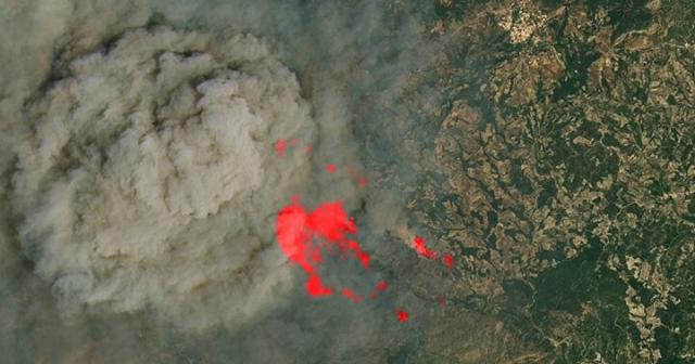
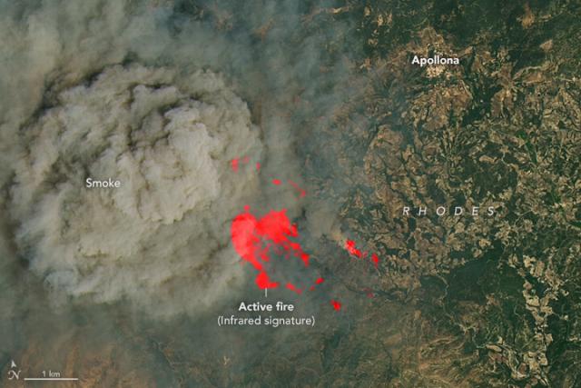
Fires Ignite on Greek Islands
Wildfires broke out on Rhodes and other islands amid record heat, forcing thousands to evacuate.go.nasa.gov
Wildfires broke out on the Greek island of Rhodes after a prolonged stretch of extreme heat.
Actively burning fires are marked by a red infrared signature in this image captured by #Landsat 8 on July 19. https://go.nasa.gov/3Q8xwF2
#NASAEarth
Fires Ignite on Greek Islands
Wildfires broke out on Rhodes and other islands amid record heat, forcing thousands to evacuate.go.nasa.gov
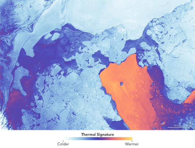
After three quiet years, the Shishaldin volcano in Alaska’s Aleutian Islands erupted this month. 🌋
Ash fallout from the eruptions can be seen on the southern flanks of the volcano in this image captured by #Landsat 8 on July 17, 2023. https://go.nasa.gov/3DwFIaF
#NASAEarth
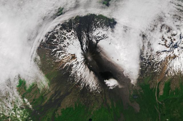
Shishaldin Erupts
Ash from recent eruptions blackened the snow-covered flanks of the Alaskan volcano.go.nasa.gov
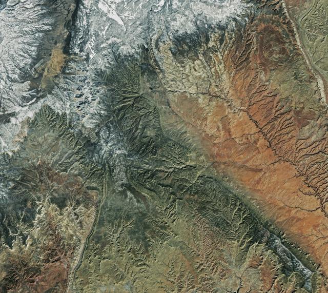
Last stop! It’s time to visit one of the U.S. National Parks. 🥾🌲
Which would you rather check off your bucket list– Bryce Canyon National Park (left) or Acadia National Park (right)?
#NASAEarth
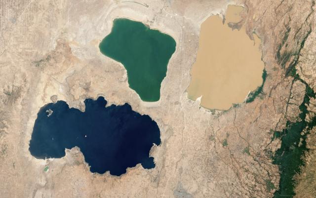
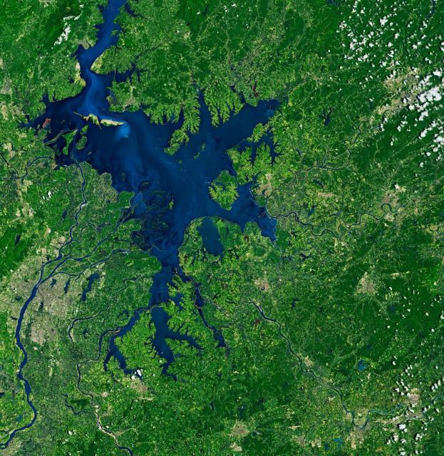
Phew, that was a tough but beautiful hike! Let’s cool off in a lake. 🏊
Which would you rather dive into – this trio of lakes in Ethiopia (left) or China’s Poyang Lake (right)?
#NASAEarth
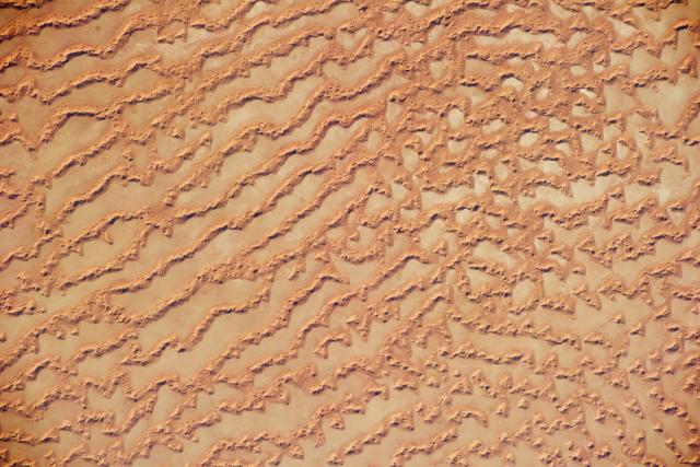
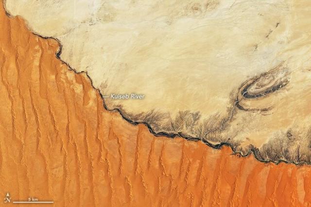
Grab your sunscreen and hiking boots! It’s time for a short hike through the desert. 🏜️
Which do you want to explore– the Rub’ al-Khali in the Arabian Peninsula (left) or Africa’s Namib Desert along the Kuiseb River (right)?
#NASAEarth
Plants and vegetation are abundant along Baugh Creek in Idaho, thanks to the ponded water from beaver dams! 🦫
A @nasa-supported effort is using @nasa satellite data to predict which streams can support beavers and monitor changes once they return. https://go.nasa.gov/3Y5eRf8
#NASAEarth
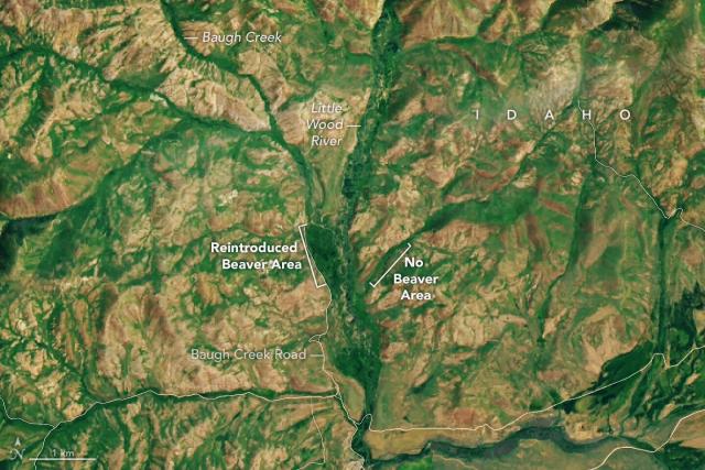
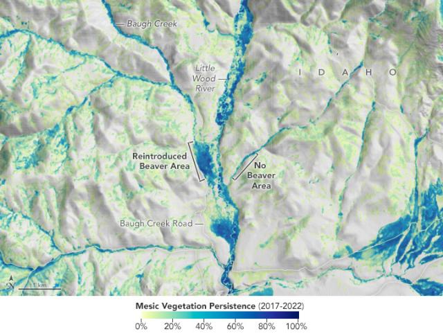
Idaho’s Emerald Refuge
Plants are abundant along Baugh Creek, thanks to the ponded water from beaver dams.go.nasa.gov
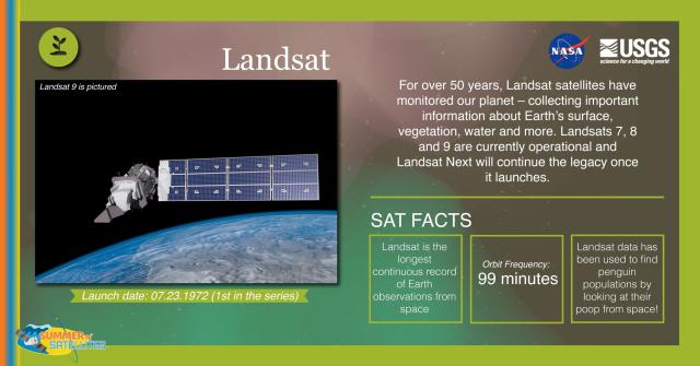
Now, Landsat Next is on the horizon 🌅
With a trio of smaller satellites that can each detect 26 wavelengths of light and thermal energy,
@nasa/@USGS #Landsat Next will provide finer resolution and more frequent data to monitor Earth’s changing surface. http://go.nasa.gov/3va23GU
[Video embedded in original tweet]
#NASAEarth

Next up to Continue NASA/USGS’s Landsat Legacy
With a trio of smaller satellites that can each detect 26 wavelengths of light and thermal energy, the Landsat Next mission is expected to look very different from its predecessors that have been observing Earth for 50 years.Kate Ramsayer (NASA)
Together, OLI and TIRS study all parts of Earth’s surface every 16 days.
From land to ice to sea, the open data provided by the #Landsat program has contributed to a deeper understanding of our changing planet. #OpenScience
#NASAEarth
#Landsat 8 and 9 also measure land surface temperature with Thermal Infrared Sensor (TIRS) and TIRS-2. These data are crucial for water management and ice detection.
#DYK that TIRS almost didn’t exist? Now it’s been imaging Earth for over a decade! http://go.nasa.gov/3OSCDbH
#NASAEarth
Ten Years of TIRS: Data for a Thirsty World | Landsat Science
Landsat 8 very nearly flew without a thermal infrared sensor. This is the backstory of how TIRS made it onto Landsat 8.https://landsat.gsfc.nasa.gov/article/author/lrocchio/#author (Landsat Science)
Both Landsat 8 and 9 have optical sensors that collect beautiful images of Earth. 😍 🌏
Called the Operational Land Imager (OLI) and OLI-2, these sensors take measurements in the visible, near infrared, and shortwave infrared portions of the electromagnetic spectrum.
#NASAEarth
51 years of eyes on Earth 👀🛰
Since 1972, the #Landsat program has been studying Earth’s land, water, ice and more.
There are currently three active @nasa @usgs Landsat satellites orbiting Earth — Landsat 7, 8, and 9 — with Landsat Next on the horizon. http://go.nasa.gov/3Nxxl4w
#NASAEarth

Landsat Science
This joint NASA/USGS program provides the longest continuous space-based record of Earth’s land in existence.Landsat Science
Look on the bright side! No, really – see how the left side appears brighter in color?
It's caused by differences in sand cover. The western side of Egypt’s Lake Nasser is covered by sand and the eastern side is mostly rock. https://go.nasa.gov/3rJy6ib
📷: @Space_Station astronaut
#NASAEarth

The Two Banks of Lake Nasser
Differences in the amount of sand cover explains the starkly contrasting colors of the Egyptian lake’s west and east banks.go.nasa.gov
Leave it to beavers to improve Earth’s ecosystems! 🦫
Scientists are studying how beavers impact ecosystems using @NASA_Landsat and Sentinel data, which help them compare across larger locations and over time. https://go.nasa.gov/3rszBkK
[Video embedded in original tweet]
#NASAEarth

"Beaver Believers" See Impacts of Rewilding Via NASA Data
Researchers are using NASA Earth observations to monitor impacts of beaver restoration on water availability in drought-prone ecosystems.Aries Keck (NASA)
so what you're saying is the time from implemented measures (mid to late 80's) to healing of the ozone layer will be approx 100 years. A century.
Now do climate change. Ya know, for those in the back.
A large wildfire broke out on La Palma, the most northwesterly of the Canary Islands.
Fires here are common in the summer due to the island’s dry climate. @nasa's Aqua satellite captured the stream of smoke on July 15. https://go.nasa.gov/46S2hEb
#NASAEarth
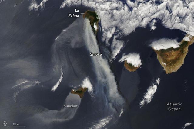
La Palma on Fire
A large wildfire in the northwest Canary Islands charred pine forests and homes.go.nasa.gov
What's going on with the hole in the ozone layer?
Thanks to a global effort to regulate ozone-depleting substances, the ozone hole is showing signs of recovery and is projected to return to a healthy level by mid-century. https://www.nasa.gov/esnt/2022/ozone-hole-continues-shrinking-in-2022-nasa-and-noaa-scientists-say
[Video embedded in original tweet]
#NASAEarth

Ozone Hole Continues Shrinking in 2022, NASA and NOAA Scientists Say
The annual Antarctic ozone hole reached an average area of 8.9 million square miles this fall, an area slightly smaller than last year and generally continuing the overall shrinking trend of recent years.Kate Ramsayer (NASA)
Dusty stripes 💨
Strong winds blew across Namibia, carrying bands of dust out to the Atlantic Ocean.
@nasa’s Aqua satellite captured the pattern, which is not unusual for this time of year when winds rush down from the interior highlands. https://go.nasa.gov/3PVwOee
#NASAEarth
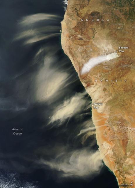
Dusts of Different Stripes
Strong winds carried desert and salt pan dust over the Atlanticgo.nasa.gov
Algae has covered about half of Florida’s largest freshwater lake, Lake Okeechobee, for much of June and early July 2023.
The @nasa/@usgs #Landsat 9 satellite captured this image of the algae bloom on June 12, which is producing harmful toxins. https://go.nasa.gov/44qmL5a
#NASAEarth
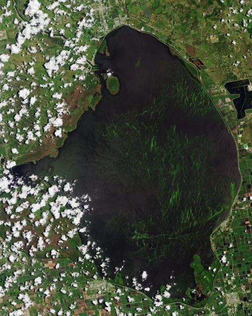
Algae Bloom in Lake Okeechobee
Cyanobacteria covered over half of the surface of Florida’s largest freshwater lake in mid-June 2023.go.nasa.gov
Meet Vince Ambrosia 👋
He’s been “putting out fires” at NASA for over 42 years. From leading the team behind new fire-monitoring technology to managing NASA Applied Sciences’ Wildland Fire program, his career leaves a lasting legacy.
https://go.nasa.gov/3BPCgqV
#NASAEarth
Vince Ambrosia: A “Man on Fire” For 42+ Years at NASA | NASA Applied Sciences
Vince Ambrosia has been “putting out fires” at NASA for more than 42 years. He’s an expert in studying wildfires using aircraft and satellites, and now he’s hanging up his fireman’s hat and retiring.go.nasa.gov
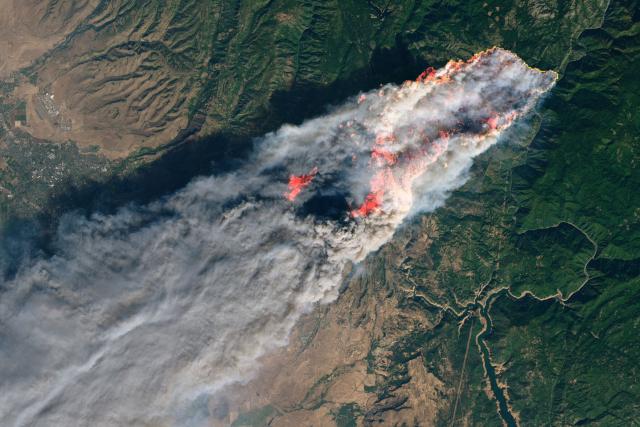
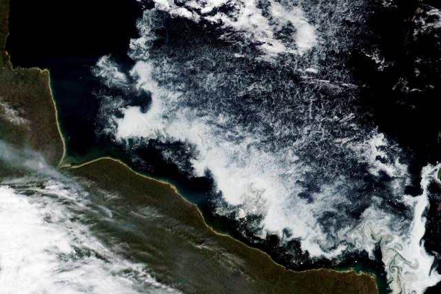
Heat, dry lightning, and drought have fueled major fires in Canada.
Nearly 600 out-of-control fires burned throughout Canada on July 13, with about half in British Columbia or Alberta, according to the CIFFC. https://go.nasa.gov/44q4EfA
🛰️: @nasa Aqua on July 12, 2023
#NASAEarth
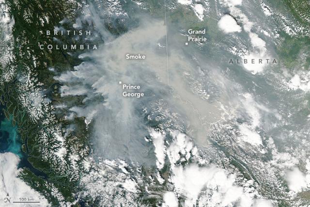
Fires Rage in British Columbia
Heat and drought have fueled an unusually large outbreak of fire in Canada.go.nasa.gov
NASA’s Disasters program is sharing satellite data to help identify the extent of flooding in Vermont. https://go.nasa.gov/3NKLbPO
The team is working with @fema, @femaregion1, @esri’s Disaster Response Program, and @uvmvermont.
🛰️: @esa Copernicus Sentinel-2A/2B on July 12
#NASAEarth
One step closer to launch ✅ 🛰️
In India, two major components of the NISAR satellite have been combined to create a single spacecraft. The joint @nasa-@ISRO mission will track movements of Earth’s land and ice surfaces in extremely fine detail. https://go.nasa.gov/3OnDgJX
#NASAEarth
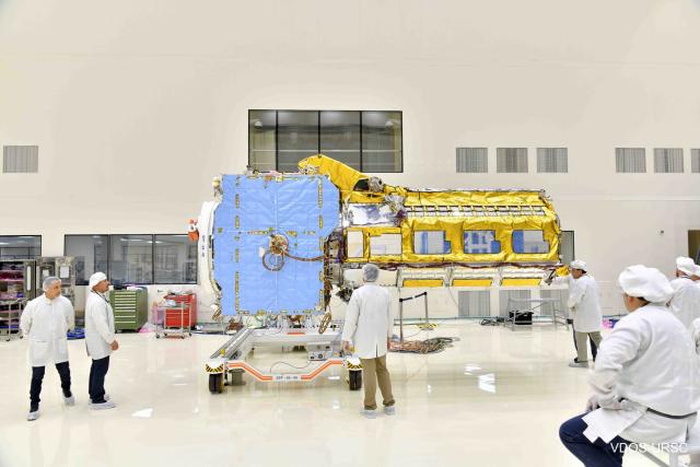
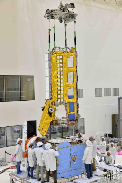
Powerful NASA-ISRO Earth Observing Satellite Coming Together in India
Built on opposite sides of the planet, the NISAR satellite will deepen understanding of climate change, deforestation, glacier melt, volcanoes, earthquakes, and more.Naomi Hartono (NASA)
Hudson Bay freezes over completely in winter and becomes ice-free for a period in summer and fall. ❄️
This melt-freeze pattern is important for many animals, especially polar bears that spend time hunting on the ice.
Image by @NOAA-20 satellite. https://go.nasa.gov/3XQ5G25
#NASAEarth
Surviving Summer in Hudson Bay
The more time polar bears spend hunting on sea ice, the better their chances are of surviving lean times on land later in the year.go.nasa.gov
Make it rain! 🌧️ Rain data, that is.
Use @NASA_Eyes to explore daily rain and snow precipitation everywhere around the world.
Explore: https://go.nasa.gov/3JOOGUf
#NASAEarth
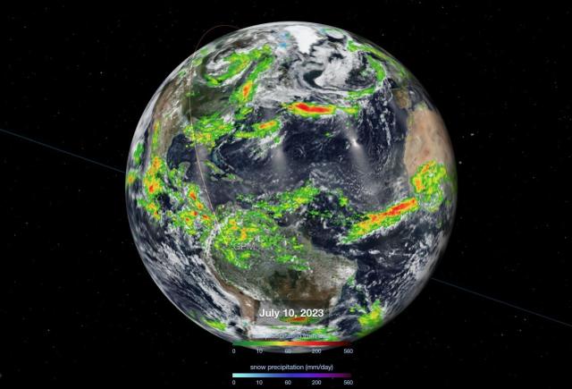
Eyes on the Earth - NASA/JPL
Welcome to NASA's Eyes, a way for you to learn about your home planet, our solar system, the universe beyond and the spacecraft exploring them.go.nasa.gov
Pitstop ahead ✅
Macquarie Island, located halfway between Australia and Antarctica, has been an important stopping place for Antarctic explorers and breeding populations of penguins and seals. 🐧
#Landsat 9 captured this image in 2022. https://go.nasa.gov/44GtNCu
#NASAEarth
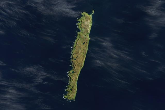
A Waypoint in the Southern Ocean
Remote Macquarie Island has been a stopover for Antarctic explorers and breeding populations of penguins and seals.go.nasa.gov
Happy #NationalCameraDay! While not a camera per se, #Landsat’s OLI instrument captures beautiful images of our planet. 🌍
The imager on the upcoming Landsat Next satellites will see changes on Earth’s surface with more precise detail than ever before. https://go.nasa.gov/3CSga7v
#NASAEarth
Landsat Next | Landsat Science
A New and Revolutionary Landsat Mission Landsat Next is on the horizon—the new mission will not only ensure continuity of the longest space-based record of Earth’s land surface, it will fundamentally transform the breadth and depth of actionable info…Landsat Science
Protecting carbon stored in ecosystems could be a powerful tool in tackling climate change, according to a @nasa study using @Space_Station GEDI data.
“This is the first time we have been able to quantify the climate impact of protected areas.”
🌲: https://go.nasa.gov/3ptW5RU
#NASAEarth
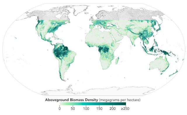
Protected Areas Safeguard Climate
Protecting carbon stored in ecosystems could be a powerful tool in tackling climate change.go.nasa.gov
This map shows biomass density This map shows biomass density across GEDI’s observation area.
More dense areas are shown in darker shades of green. GEDI doesn’t collect data north of about 52 degrees latitude.
#NASAEarth
