Search
Items tagged with: nasaearth

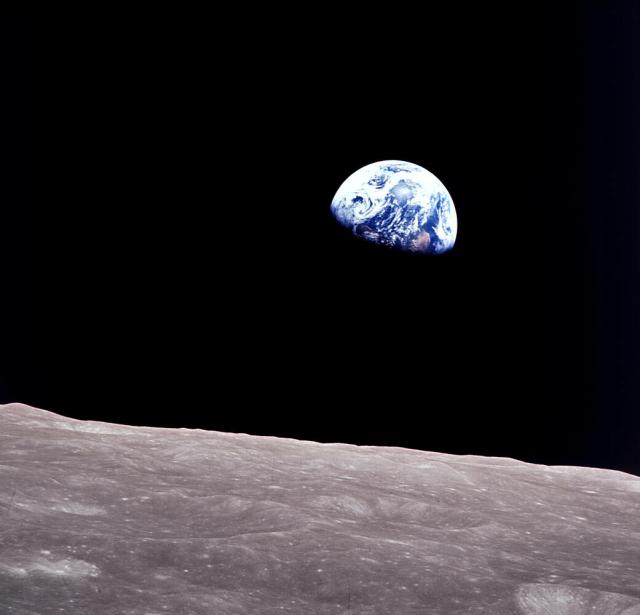
Earthrise.
On Christmas Eve of 1968, the Apollo 8 crew photographed Earth rising over the lunar surface as they orbited the Moon.
“We came all this way to explore the Moon, and the most important thing is that we discovered the Earth." – William Anders go.nasa.gov/3GcD3F4
#NASAEarth
All of You on the Good Earth
These iconic photos are not new, but their message never gets old.go.nasa.gov

Happy holidays! 🎉 @nasa celebrates holidays all year long.
Tune into this special bonus episode of NASA’s Curious Universe podcast to hear how NASA celebrates, from Pi Day to May the 4th and more!
🎧: nasa.gov/curiousuniverse
#NASAEarth

NASA's Curious Universe
NASA.gov brings you the latest images, videos and news from America's space agency. Get the latest updates on NASA missions, watch NASA TV live, and learn about our quest to reveal the unknown and benefit all humankind.NASA
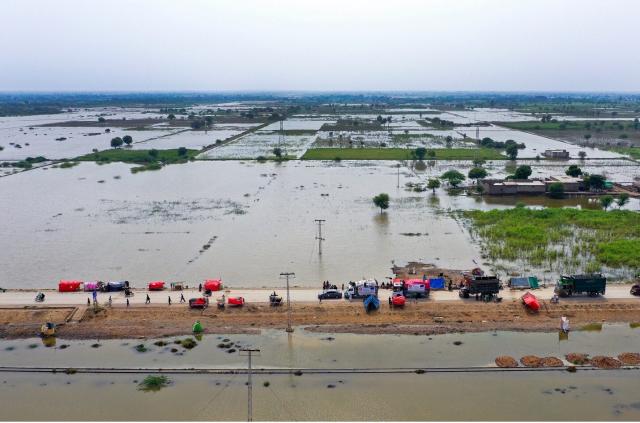
Early warnings on floods can save lives, but roughly half of the world's countries lack adequate early warning systems.
That's about to change, thanks to a new tool developed by @nasa and the Pacific Disaster Center (PDC).
Learn more: go.nasa.gov/3PV3wu7
#NASAEarth
NASA Partnership Launches Groundbreaking New Global Flood Early Warning Technology | NASA Applied Sciences
Floods are among the most deadly and destructive disasters worldwide, and climate change has only increased their severity.go.nasa.gov
This is the first time comprehensive global flood early warnings at the sub-watershed level have been possible.
Thanks to MoM and DisasterAWARE, small and vulnerable communities now have a powerful new tool to take early action on flooding and protect lives and livelihoods.
#NASAEarth

Santa better bundle up. 🎅🥶
A blast of Arctic air will bring cold conditions to Canada and the central and eastern U.S. This map shows abnormally cold temps (blue) forecasted for Dec. 23 using satellite observations and @nasagoddard's GEOS model.
More: go.nasa.gov/3vbRSBu
#NASAEarth

The Freezing Snowy Nightmare Before Christmas
A blast of Arctic air will plunge south and help trigger a powerful blizzard that will churn through the central and eastern U.S.go.nasa.gov
Today is the #WinterSolstice, aka the official start of astronomical winter! ❄️
We’re celebrating with some snowy and solst-icy 🧊 photos taken from the @Space_Station.
See more: go.nasa.gov/3PLxj8l
#NASAEarth
Collection - Winter from the International Space Station
climate change, global climate change, global warming, natural hazards, Earth, environment, remote sensing, atmosphere, land processes, oceans, volcanoes, land cover, Earth science data, NASA, environmental processes, Blue Marble, global mapsgo.nasa.gov
👩🚀📸: go.nasa.gov/3jhgWVc
#NASAEarth

Strait of Messina
Sunglint, waves, and ship wakes are visible on the waters between Italy’s Calabria region and Sicily.go.nasa.gov
This map shows lightning flashes detected by a sensor on the @Space_Station in the span of two minutes during a Dec. 13 storm. 🌩️
Size represents number of lightning flashes. Colors indicate flash brightness. The data are overlaid on a @noaa GOES image. go.nasa.gov/3hNlp1c
#NASAEarth
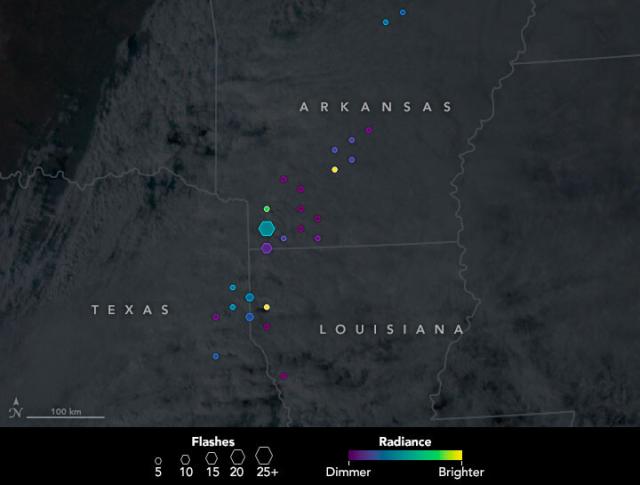
Lightning in the U.S. South
Dangerous thunderstorms and destructive tornadoes lashed the U.S. South amid a sprawling winter storm in December 2022.go.nasa.gov
The new @NearSpaceNet antennas will enhance direct-to-Earth communications – the process by which a satellite takes a picture and then sends the image over radio waves to an antenna on Earth. 🛰📸🌏
Learn more: go.nasa.gov/3G4Q8QY
#NASAEarth

NASA Enables Future of Science Observation through Tri-band Antennas
NASA’s Near Space Network enables spacecraft exploring the solar system to send back essential science data for researchers and scientists to investigate and make profound discoveries.Katherine Schauer (NASA)
#NASAEarth


Worst Drought on Record Parches Horn of Africa
The most severe drought in 70 years of record keeping threatens the Horn of Africa with famine.go.nasa.gov
Social scientist Jason Vargo studies the intersection of severe weather events, their health impacts, and community development in his role as a researcher at @SFFED.
In this audio story, hear how @NASAEarth science data is making his job easier.
🎧: go.nasa.gov/3BNcK5S
#NASAEarth
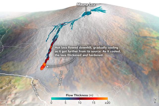
These airborne measurements helped @usgs scientists calculate that 230 million cubic meters of molten rock poured from the volcano during the two-week eruption.
Full story: go.nasa.gov/3hAKBrM
#NASAEarth

Sizing up Mauna Loa’s Lava Flows
Airborne mapping of the thickness of the lava flows helped scientists calculate that 230 million cubic meters of molton rock poured from the volcano during the two-week eruption.go.nasa.gov
Earth from space has us like 😍
An astronaut onboard the @Space_Station took this photo of Isle Royale National Park in April 2020, while the park’s islands were partially covered in snow. 👩🚀📸go.nasa.gov/3WbqtLK
#NASAEarth

The Frozen Landscape of Isle Royale
The park is one of the most isolated natural areas in the continental United States and the site of long-running ecological studies.go.nasa.gov
#Landsat 8 captured this natural color image of Saba Island, an active stratovolcano located about 140 kilometers east of the U.S. Virgin Islands in the Caribbean Sea.
🌋 go.nasa.gov/3j6wdYV
#NASAEarth
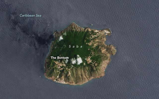
Saba Island
The quiet Caribbean island has been a destination for divers looking to spot corals and sea urchins.go.nasa.gov
#NASAEarth
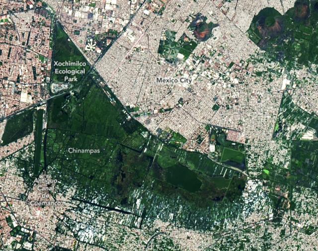
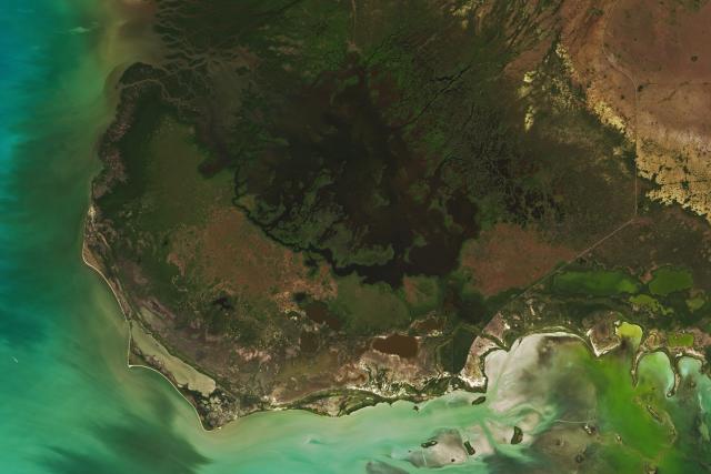
Relic Chinampas in Mexico City
Many of the canals and floating fields used by ancient civilizations in the Valley of Mexico were lost as lakes were drained, but some examples of the watery fields remain in Xochimilco.go.nasa.gov
A rare December sandstorm in China darkened skies over several major cities.
This image from @nasa’s Terra satellite, taken on Dec. 12, shows plumes of sand and dust from the Gobi Desert spanning parts of Hebei, Shanxi, Liáoníng, and Jílín provinces. go.nasa.gov/3BBZbGb
#NASAEarth

Winter Sandstorm in China
A rare December sandstorm in China darkened skies in several cities.go.nasa.gov
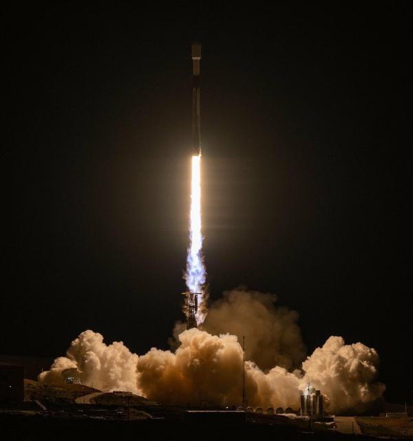
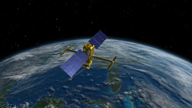
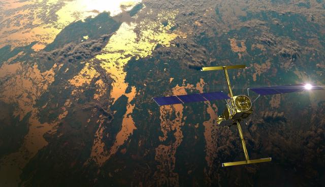
Welcome to the team, SWOT! 🛰️
The international mission will observe nearly all of Earth's water and help address some of the most pressing climate questions of our time.
nasa.gov/press-release/nasa-la…
#NASAEarth

NASA Launches International Mission to Survey Earth’s Water
A satellite built for NASA and the French space agency Centre National d’Études Spatiales (CNES) to observe nearly all the water on our planet’s surface lifted off on its way to low-Earth orbit at 3:46 a.m. PST on Friday.Gerelle Dodson (NASA)
Welcome to the team, SWOT! 🛰️
The international mission will observe nearly all of Earth's water and help address some of the most pressing climate questions of our time.
nasa.gov/press-release/nasa-la…
#NASAEarth
NASA Launches International Mission to Survey Earth’s Water
A satellite built for NASA and the French space agency Centre National d’Études Spatiales (CNES) to observe nearly all the water on our planet’s surface lifted off on its way to low-Earth orbit at 3:46 a.m. PST on Friday.Gerelle Dodson (NASA)
Today is the last day @nasa scientists are talking about #NASAScience from the hyperwall at #AGU22, including how NASA views Earth from space! 🌎
Miss a talk? Not at AGU? Check out the virtual exhibit: Go.nasa.gov/NASAScienceNow
#NASAEarth


We are all connected by water. The SWOT satellite will survey nearly all of Earth's water and help address some of the most pressing climate questions of our time.
🚀 Scheduled to launch Dec. 15 at 3:46am PT from Vandenberg Space Force Base
Watch live: go.nasa.gov/3PxglL8
#NASAEarth

Launch of the International SWOT (Surface Water and Ocean Topography) Mission (NASA Broadcast)
Watch with NASA as we launch an international mission to understand the Earth's water like never before.SWOT, the Surface Water and Ocean Topography mission,...YouTube
We are all connected by water. The SWOT satellite will survey nearly all of Earth's water and help address some of the most pressing climate questions of our time.
🚀 Scheduled to launch Dec. 15 at 3:46am PT from Vandenberg Space Force Base
Watch live: go.nasa.gov/3PxglL8
#NASAEarth
Launch of the International SWOT (Surface Water and Ocean Topography) Mission (NASA Broadcast)
Watch with NASA as we launch an international mission to understand the Earth's water like never before.SWOT, the Surface Water and Ocean Topography mission,...YouTube
go.nasa.gov/3UZA5rC
#NASAEarth
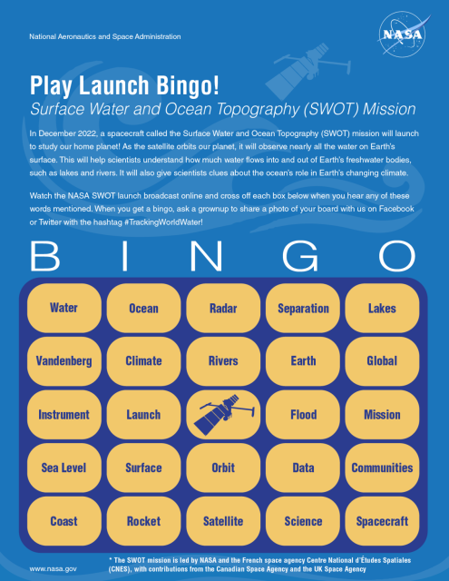
SWOT Launch Bingo | NASA Space Place – NASA Science for Kids
During the launch broadcast, you can mark off the words that you hear!go.nasa.gov
Observations from the EMIT mission and other NASA science instruments will be part of a global survey of point-source emissions of methane from landfills. The multiyear effort is being developed and conducted by the nonprofit Carbon Mapper organization.
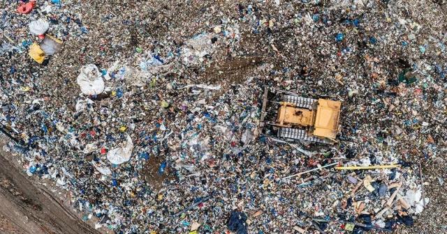
NASA Sensors to Help Detect Methane Emitted by Landfills
A nonprofit group, Carbon Mapper, will use data from NASA’s EMIT mission, plus current airborne and future satellite instruments, to survey waste sites for methane emissions.Tony Greicius (NASA)
The Surface Water and Ocean Topography mission will track water on more than 90% of Earth’s surface.
Spruce up your space with this mission poster and get ready for launch: go.nasa.gov/3Yq90kf
#TrackingWorldWater
#NASAEarth
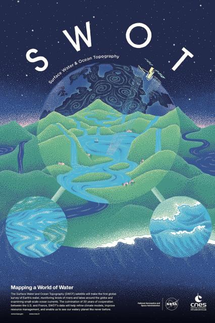
Surface Water and Ocean Topography (SWOT) Mission Poster | NASA SWOT
This collaborative mission poster, designed by CNES (French Space Agency), shows the Surface Water and Ocean Topography (SWOT) satellite soaring over an abstract of a water molecule.NASA SWOT
In 2020 and 2021, global atmospheric concentrations of methane – a potent greenhouse gas – surged in record growth since measurements began ~40 years ago.
This video shows global methane emissions from wetlands since 1980. Wetlands are one of the largest single methane sources.
#NASAEarth
Wetlands store massive quantities of carbon in soils. But as the climate gets warmer or wetter, microbes in the wetlands start releasing more methane into the atmosphere.
On Dec. 14 at 2pm ET, @nasa scientists are discussing their findings at #AGU22. go.nasa.gov/3UYuIcp
#NASAEarth
NASA Press Events at 2022 Fall AGU Meeting
NASA researchers will be presenting findings on Earth and space sciences Dec.12-16 at the American Geophysical Union's 2022 Fall meeting, being held virtually and in Chicago this year.Karen Fox (NASA)
This fall, @nasagoddard scientists trekked through and flew over Florida marshes as part of the Blueflux project.
The team is studying the exchange of carbon and methane through mangrove ecosystems with research aircraft and scientists on the ground. 🛫 🛶go.nasa.gov/3Wjds2I
#NASAEarth


For the first time, @nasa scientists mapped global salt marsh losses and their carbon impact.
The world has lost 561 square miles (1,453 square kilometers) of marshes over the past 20 years, the team found. go.nasa.gov/3FvLcCT
#NASAEarth
NASA Scientists Map Global Salt Marsh Losses and Their Carbon Impact
Earth has lost 561 square miles of salt marshes over the past 20 years, according to a new NASA-led study of the first consistent global accounting of salt marsh locations and changes.Kate Ramsayer (NASA)
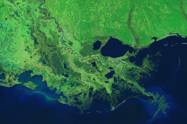
In a new study, scientists used #Landsat imagery from @nasa/@usgs to track shoreline changes and dramatic wetlands losses in Louisiana from 1984 to 2020.
The state lost nearly 21 square miles of important and vulnerable wetland ecosystems every year. go.nasa.gov/3UVZHFN
#NASAEarth
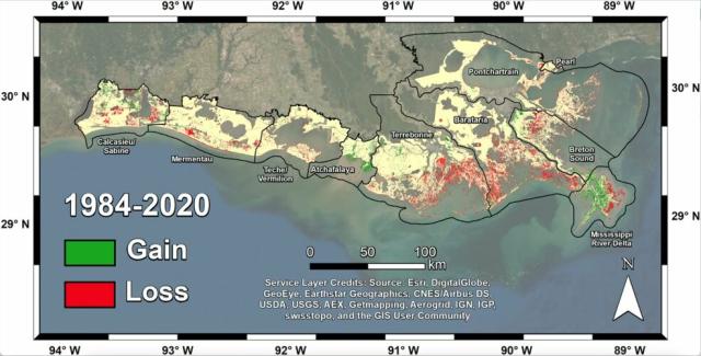
Satellites Help Scientists Track Dramatic Wetlands Loss in Louisiana
New research uses NASA satellite observations and advanced computing to chronicle wetlands lost (and found) around the globe.Kate Ramsayer (NASA)
NASA’s satellite data indicate a larger wheat harvest in Ukraine than expected – nearly 27 million tons – but some crops went unharvested.
Full story: go.nasa.gov/3HwH3Bs
#NASAEarth

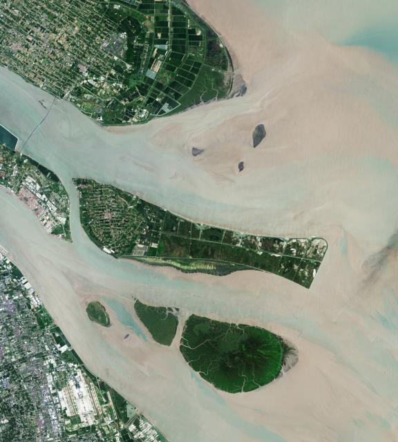
Larger Wheat Harvest in Ukraine Than Expected
A satellite-based analysis indicates that nearly 27 million tons of wheat were harvested from the country’s farms this year, but Ukraine won’t reap all of the benefits.go.nasa.gov
#Landsat 8 captured the image below showing harvested wheat around the town of Bereznehuvate compared to unharvested wheat around Velyka Oleksandrivka.
Satellite data help provide rapid agricultural assessments, important for markets and food security. go.nasa.gov/3HwH3Bs
#NASAEarth
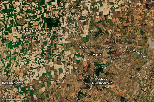
Larger Wheat Harvest in Ukraine Than Expected
A satellite-based analysis indicates that nearly 27 million tons of wheat were harvested from the country’s farms this year, but Ukraine won’t reap all of the benefits.go.nasa.gov
#NASAEarth


NASA Science Hyperwall Stories at the American Geophysical Union Fall Meeting 2022 – Monday, 12/12
Join NASA experts at the 2022 American Geophysical Union Fall Meeting in Chicago, IL. You will hear about Planetary Science highlights of 2022 and plans for ...YouTube
Earth is experiencing a weak but prolonged La Niña – cooler sea surface temperatures in the tropical Pacific. 🌊
This is the third consecutive northern hemisphere winter with a La Niña, making it a rare “triple-dip” event. go.nasa.gov/3iW1PjR
#NASAEarth

La Niña Times Three
Three consecutive years of La Niña conditions in the eastern Pacific Ocean make this a rare “triple dip” event.go.nasa.gov
