Search
Items tagged with: nasaearth

#NASAEarth
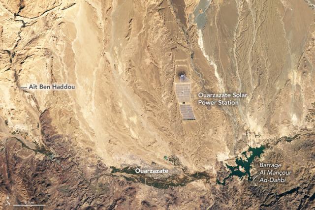
Sunny Days in Morocco’s Ouarzazate Basin
The dry, sunny basin is the site of a solar power station that supplies electricity to nearly 2 million Moroccans.go.nasa.gov

Pass the salt 🧂
A @Space_Station astronaut snapped this photo of Laguna Ojo de Liebre in Mexico in 2022.
The coastal lagoon has many evaporation ponds that are used to produce salt. go.nasa.gov/409kidq
#NASAEarth
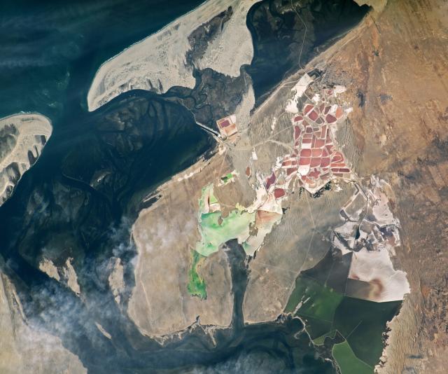
Evaporation from Laguna Ojo de Liebre
An astronaut spotted colorful evaporation ponds in Mexico while in orbit over the Baja Peninsula.go.nasa.gov
Once a small canal, Louisiana's Neptune Pass has widened to become a major channel in the last six years.
#Landsat 8 captured these images before the canal widened (left) in 2019 and after in 2023 (right).
Full story: go.nasa.gov/3nc1rzI
#NASAEarth
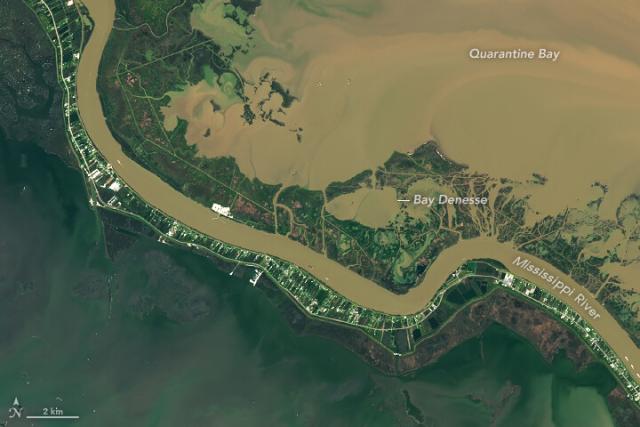
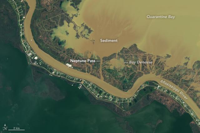
The Widening of Neptune Pass
The pass now has a flow five times that of New York’s Hudson River.go.nasa.gov
Most landscapes in North America are fire-adapted, and frequent fires enable trees and wildlife to flourish.
In this image, red dots indicate active fires in the U.S. Southeast as detected by the @nasa @noaa Suomi NPP satellite on March 14, 2023. 🔥 go.nasa.gov/3z5k1w6
#NASAEarth

Thriving With Fires
Frequent fires in the pine forests in the southeastern United States enable trees and other wildlife to flourish.go.nasa.gov
Prescribed (or controlled) burns are often used to manage forests and forest undergrowth.
Cropland or prescribed fires are responsible for 77% of active fire detections in the U.S. using @nasa MODIS data. go.nasa.gov/3z5k1w6 🔥
#NASAEarth
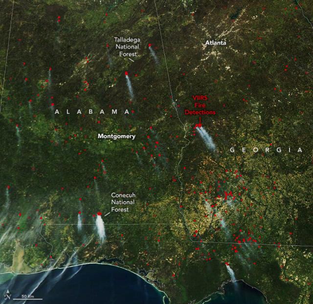
Thriving With Fires
Frequent fires in the pine forests in the southeastern United States enable trees and other wildlife to flourish.go.nasa.gov
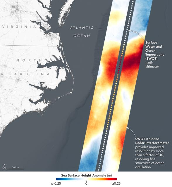
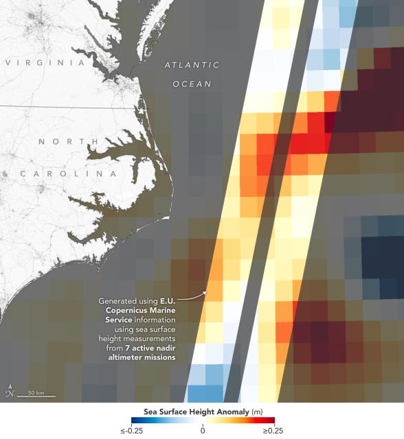
A whole new view 🤩 🌊
First taste from the SWOT mission shows Earth’s water in higher definition than ever before. The spatial resolution of SWOT ocean measurements is 10 times greater than sea surface height data gathered over the same area by seven other satellites combined.
#NASAEarth
#NASAEarth
Meet Laura Judd, an air quality researcher at @NASA_Langley. 👋
She uses data from satellites and research aircraft to study air pollutants like nitrogen dioxide, which is a precursor to ozone near Earth’s surface. #WomenInScience #WomensHistoryMonth
#NASAEarth

#NASAEarth
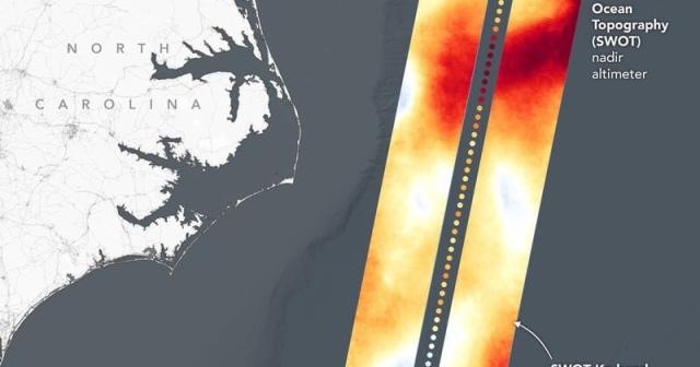
Joint NASA, CNES Water-Tracking Satellite Reveals First Stunning Views
The Surface Water and Ocean Topography mission offers the first taste of the detailed perspectives of Earth’s surface water that its cutting-edge instruments will be able to capture.Tony Greicius (NASA)
The airborne instruments she uses are similar to what will be on NASA’s upcoming TEMPO mission.
Scheduled to launch in April 2023, TEMPO is a geostationary satellite that will measure ozone, air pollutants, and more every hour.
Learn about TEMPO: go.nasa.gov/3Z4yItW
#NASAEarth
Laura Judd came to NASA through the SARP summer internship program, where she assisted with @nasa air pollution research as a college student studying meteorology.
Learn about SARP: go.nasa.gov/3JCTKKj
#NASAEarth

#NASAEarth
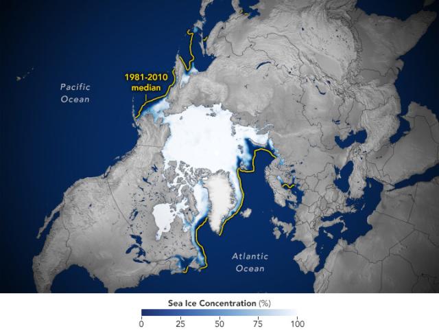
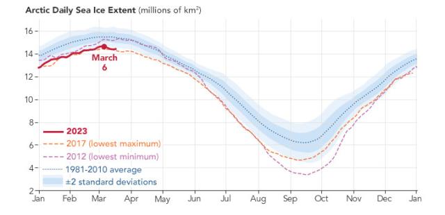
Arctic update: On March 6, 2023, Arctic sea ice appeared to reach its annual maximum extent (or coverage) at 14.62 million square kilometers (5.64 million square miles) – the fifth lowest in the satellite record maintained by the @NSIDC.
Learn more: go.nasa.gov/3neiPnx
#NASAEarth
Arctic Sea Ice Below Average in Winter 2023
The end-of-winter sea ice extent in March 2023 was the fifth lowest in the satellite record.go.nasa.gov
Since the start of the satellite record in 1979, the ten lowest maximums have all occurred within the past two decades.
NASA’s fieldwork and satellites monitor the changing ice pack, helping to predict how the ice will change in the future.
#NASAEarth
Carbon plays a role in all of Earth's systems, including the ocean.
@nasa's upcoming PACE mission will give us a whole new way to see the seas. PACE is designed to measure carbon from the sky and land to the ocean.
#WorldWaterDay 🌊
Dive in: go.nasa.gov/3lvVLjD
#NASAEarth
#NASAEarth
#NASAEarth
#NASAEarth
Previously, it was uncertain how many deaths linked to PM2.5 were associated with dust.
According to the team’s estimates, 22 percent of the premature deaths associated with PM2.5 were due to dust—much of this in a “dust belt” that spans from West Africa to East Asia.
#NASAEarth
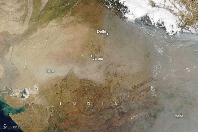
Windblown dust and human-caused particle pollution called PM2.5 likely contributed to 2.89 million premature deaths in 2019, according to research led by @nasagoddard scientists.
How Dust Affects the World’s Health
NASA research finds that a combination of windblown dust and human-caused particle pollution was associated with nearly 3 million premature deaths in 2019.go.nasa.gov
Longer days are on the horizon! ☀️ 🌸
The March equinox marks the first day of spring in the Northern Hemisphere. It's also a time when the length of day and night are nearly equal.
Learn more: go.nasa.gov/40hcGVO
#NASAEarth
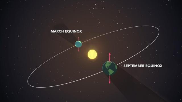
What Causes the Seasons? | NASA Space Place – NASA Science for Kids
The answer may surprise you.go.nasa.gov
Potosí, the Bolivian mining city and one of the highest cities in the world, grew at the foot of an eroded volcano riddled with silver.
#Landsat 8 captured this image of Potosí and the nearby mountain, Cerro Rico, on November 24, 2022.
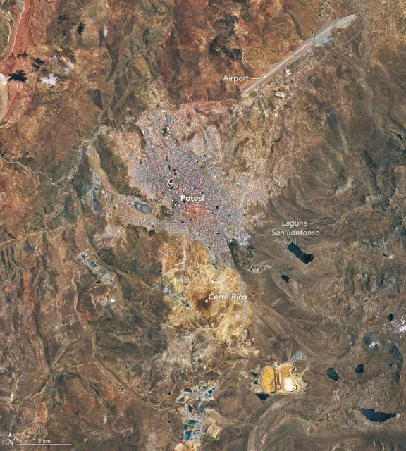
Potosí and Cerro Rico
The Bolivian mining city—one of the highest cities in the world—grew at the foot of an eroded volcano riddled with silver.go.nasa.gov
An astronaut aboard the @Space_Station took this photo of the lower Amazon River in Brazil, which carries a huge amount of sediment and occasionally delivers muddy water to nearby lakes.
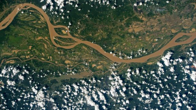
Muddy Water and a Wide Floodplain
The mighty Amazon River carries a huge amount of sediment and occasionally delivers muddy water to nearby lakes.go.nasa.gov
Two successive atmospheric rivers hit California this month, bringing rain, snow, and strong winds. On March 16, NASA’s Terra satellite acquired this false-color image where snow is light blue, water dark blue, and vegetation green.
🔗 go.nasa.gov/3JQoV6u
#NASAEarth
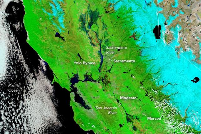
Precipitation Piles on in California
Successive atmospheric rivers in March dropped even more rain and snow throughout the state.go.nasa.gov
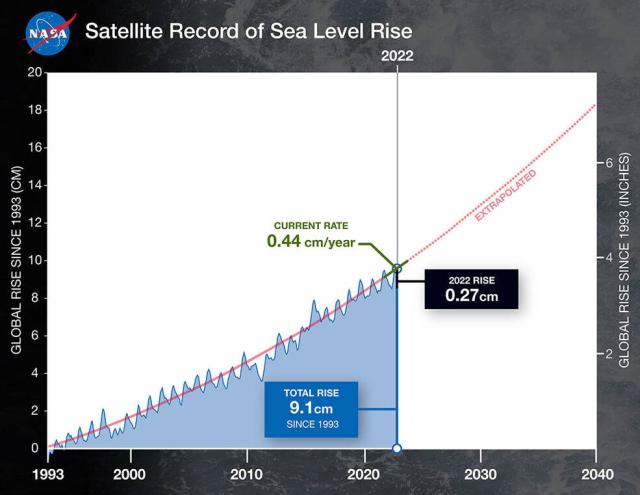
The rate of sea level rise has more than doubled since 1993. Using a 30-year satellite record, @nasa is helping researchers and coastal planners track how much rise is happening so that we can prepare for where sea level rise is headed.
Details: go.nasa.gov/3yN1hkM
#NASAEarth
NASA Uses 30-Year Satellite Record to Track and Project Rising Seas
Observations from space show that the rate of sea level rise is increasing. Knowing where and how much rise is happening can help coastal planners prepare for future hazards.Tony Greicius (NASA)
#NASAEarth
#NASAEarth
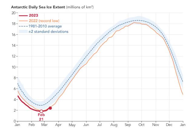
Sea ice around Antarctica reached its lowest extent on Feb. 21, 2023, at 1.79 million square kilometers (691,000 square miles).
This is the lowest extent ever observed since the start of the satellite record in 1979.
go.nasa.gov/3ZUsNZx
#NASAEarth
Antarctic Sea Ice Reaches Another Record Low
The long-term trend for sea ice in the south is still flat, while the global trend points downward.go.nasa.gov
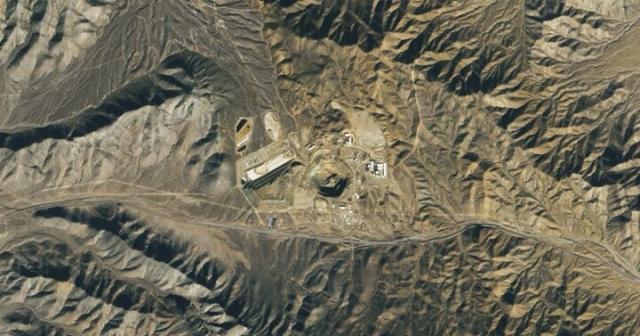
The mountains of southeastern California are home to a large rare-earth element mine.
#Landsat 8 captured this image of the Mountain Pass Mine, with an open-pit area that extends 800 meters (2,600 feet) across and more than 180 meters (590 feet) deep. go.nasa.gov/3FqrY2o
#NASAEarth
“Tódích’íí’nii nishłį́.”
“I am Bitter Water.”
That’s how Nikki Tulley would identify herself as a Navajo woman. Learn how her experiences growing up on Navajo Nation shaped her approach to water access as a scientist at
@NASAAmes.
go.nasa.gov/3FjkoGH #WomensHistoryMonth
#NASAEarth
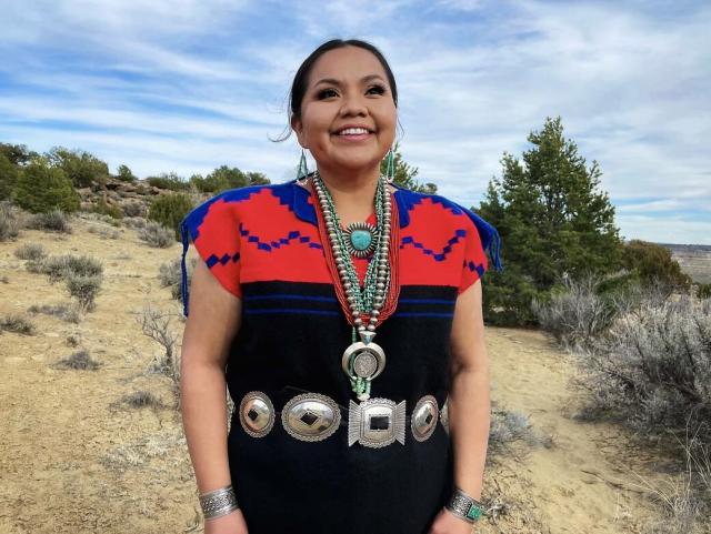
Assistant Research Scientist Nikki Tulley
“Shí éí Nikki Tulley yinishyé. Tódích’íí’nii nishłį́. If I were to identify myself in my community, in my language, that’s the first part of the greeting I would say: ‘I am Nikki Tulley. I am Bitter Water.Roberto Molar-Candanosa (NASA)
#NASAEarth
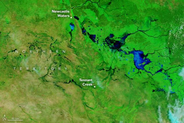
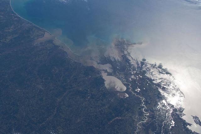
The surge of rain pushed rivers beyond their banks and forced evacuations from several communities.
For comparison, NASA’s Aqua satellite captured an image of the same area on March 5, 2022, during drier times.
Details: go.nasa.gov/3mTusjx
#NASAEarth
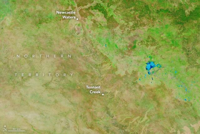
Floods Swamp Australia’s Northern Territory
Days of rain have swollen rivers and lakes in the sparsely populated territory.go.nasa.gov
Destination: Mayotte’s lagoon 🤿🌊
Coral reefs surround the volcanic islands of Mayotte, the easternmost islands in the Comoros archipelago. The area is home to a diversity of wildlife, including corals, clownfish, and green sea turtles.

Mayotte’s Lagoon
Coral reefs surround the volcanic islands of Mayotte, the eastern-most islands in the Comoros archipelago.go.nasa.gov
Is this photograph 3D? 🤔
Nope, but it looks that way! The oblique angle of the photo, taken from the @Space_Station, along with shadows from New York City skyscrapers give the photograph a sense of three-dimensionality.
🔗 go.nasa.gov/3FlFnsJ
#NASAEarth

New York and New Jersey
Shadows from skyscrapers and other city buildings give the photograph a 3D look.go.nasa.gov
Even if you don't live in an area where they are common, wildfires impact your life. Fires shape ecosystems and affect air quality.
Explore how we track wildfires from space in the latest episode of NASA’s Curious Universe podcast: nasa.gov/curiousuniverse 🎧 🔥
#NASAEarth
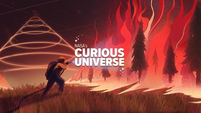
NASA's Curious Universe
NASA.gov brings you the latest images, videos and news from America's space agency. Get the latest updates on NASA missions, watch NASA TV live, and learn about our quest to reveal the unknown and benefit all humankind.NASA
As we move closer to the peak of solar cycle 25, activity on the Sun is ratcheting up. One sign of this is the aurora borealis, or northern lights, in Earth’s atmosphere.
@nasa astronaut @astro_josh took this photo from the @Space_Station on Feb. 28. go.nasa.gov/3mwxudo
#NASAEarth

A Dazzling Aurora Borealis
Astronauts and sky watchers oohed and aahed as the night sky lit up with pulsating displays of reds, greens, and purples.go.nasa.gov
What’s for dinner?
The #Landsat mission observes crops from space, helping farmers make decisions about how to better grow food. In this data sonification, see and hear how crops in the U.S. have changed over 20 years.
How #Landsat data is used: go.nasa.gov/3T5z6GZ
#NASAEarth
From Space to Farm
Farmers rely on the accuracy of a crucial NASA and USGS mission, Landsat, to make decisions about crops. Those decisions have far-reaching implications that can impact what you see on your dinner plate!Sarah Loff (NASA)
This visualization shows simulated corn (yellow) and soybean (green) yields in Iowa from 2001-2020.
NASA builds crop models to understand how conditions like weather, soil type, and farm management affect the production of crops like corn and soybean.
#NASAEarth